
Prehistoric sites within 5km of SX 59214 94456
Guidance for walkers: The monuments featured in this database are archaeological treasures and need to be protected and preserved - please do not disturb any sites. Please check access and firing times before visiting sites, not all sites listed are on open access land. Firing ranges and boundaries of open access areas are marked on the OL28 OS Dartmoor Explorer map. Please stick to the country code and consider giving support to the numerous agencies that help to keep Dartmoor a fabulous natural and historic environment!
About the database listings: In all listings clicking on the photo or the site name will open a page for the site with a larger photo and further details from the database. The database now has over 6680 records covering nearly all publicly listed sites on Dartmoor including around 4800 round houses. This level of detail is of interest to archaeologists but tends to swamp listings of sites more likely to be of interest for walkers. For this reason, the listings default to around 550 core sites only. These are the stone circles, stone rows and the ring cairns listed by Turner. The default search radius is 2 km. The controls below the map can be used to start a new search by entering a 6- or 8-digit reference (without the prefix "SX"). The search radius can be specified and you can add incremental Display layers of detail on top of the core sites. If using a more detailed layer you will need to decrease the search radius to avoid getting hundreds of search results.
- Core sites Default listing of core sites consisting of stone circles & rows and some of the major ring cairns.
- Plus cairns adds approx. 1000 cairns and other minor sites not included in the core listings but excluding round houses.
- Plus round houses adds approx. 4800 round houses.
- Plus non-sites adds in the records for sites that no longer exist or are not prehistoric sites.
- Plus duplicates adds records excluded as duplicates. Those maybe duplicate records in external listings (e.g. the Historic Environment Records). For example, some sites have been identified as cairns in some listings and interpreted as round houses in other listings and both records appear.
These listings have incorporated, matched up and merged all of the records from all of the major archaeological listings including: Worth, Grinsell, Turner, Butler, Bill Radcliffe, Sandy Gerrard, Megalithic Portal, the National Monument Records and the Historic Environment Records. The author would like to thank Bill, Sandy, the lovely people both at Megalithic Portal (especially Anne Tate who did an amazing job to link listings) and at ACE Archaeology for collaborative work over the years to synchronise and correct listings across the various websites which now interlink. A culmination of years of work the final merger of cairn records took 3 months of cross referencing in 2017 the result being a snapshot of the records at that time. This data has in turn been refined since by field work and research. The round house data was supplied by Sandy Gerrard. Grid references are in order of accuracy: from Google Earth satellite, if visible and found, from a Garmin GPS reading, if visited by the author and from the literature otherwise. Individual site pages will state the source of the grid reference and provide satellite imagery. If a site listing lacks a photo it has not yet been visited by the author in which case the grid reference is from the literature.
Currently the database only includes sites which can be represented by a grid reference. Reaves are not included as they require GIS shape technology which is beyond the current capability of this system. To see the sources for the records, look at the tables on the resources menu. The database listings can also be viewed on a Google map and downloaded as GPS datasets for Garmin devices.
Corrections, or any feedback or suggestions are very welcome, email: info@dartmoorwalks.org.uk.
NOTE: Clicking on the icons for each monument in the map will give the name of the site. You can zoom in and out and drag the map around.
List of sites within 5km of SX 59214 94456
Cosdon Hill N.W.2 Cist
OS Map: SX 63040 92659
HER: MDV63639
ShortName: CT:Cosdon NW2
Butler map: 40.10
Notes: Cairn measures 9.5 metres in diameter, height 1 metre. Cist 3 metres by 3 meters by 0.1 metre deep. Grass, heather and gorse covered mound with stones protruding through the turf on the northern side of the mound. The author was unable to locate this site within the dense vegetation cover on 13/09/21.
Nearby sites: SX 63040 92659
Distance: 4.23km
Halstock Down 8 Stone Ring Cairn Circle
OS Map: SX 5957 9212
HER: MDV58788
ShortName: RC:Halstock 8
Notes: HER: is=28/3/1998 (greeves) prehistoric ring cairn immediately on w side of rough track about 90m n of point where track joins tarmac road. External diam is c.22m-25m. The ring bank is c.4m wide where best preserved (on nw side) by c.0.4m high (max).
Nearby sites: SX 5957 9212
Distance: 2.36km
Cosdon Hill N.3 Cist
OS Map: SX 63604 93067
HER: MDV6918
PMD: Skaigh
ShortName: CT Cosdon N3
Butler map: 40.8.3
Grinsell: ST 9
Notes: The remains of the cist, almost certainly that noted by Crawford, consist of two end stones 0.8 metres high and 0.5 metres wide, 1.8 metres apart and oriented north-west/ south-east. Between these uprights lie two fallen granite side-slabs, 1.5 metres long and 0.5 metres wide. "Butler believes these may be the remains of a well-known stone setting called the Eight Rocks which existed on the hillside here until sometime in the 19th century. This was probably the remaining circle of a cairn like the Nine Stones or Nine Maidens on Belstone Common (PRN6865), reputed to come alive and dance (Crossing, 1912)."
See the entry for Eight Rocks for further discussion.
Nearby sites: SX 63604 93067
Distance: 4.60km
Halstock Down 3 Stone Ring Cairn Circle
OS Map: SX 5976 9218
HER: MDV60254
ShortName: RC:Halstock 3
Notes: HER: A severely damaged cairn lies on the south west flank of Halstock Down 65 metres above the military ring road. All that remains is a stony fringe 1.2 to 1.6 metres wide and 0.4 metres high indicating an original diameter of around 20 metres for this feature. The interior of the cairn has been removed down to the old ground surface which has been further disturbed by later pits.
Also In the southern field is a circular bank measuring up to 3m wide and 0.6m high surrounding a 17.5m diameter internal area. The ring bank has been cut in four places by military pits and others in the vicinity further confuse the situation. Despite this, it is clear that this earthwork represents the site of a ring cairn.
Nearby sites: SX 5976 9218
Distance: 2.34km
Halstock Down 4 Stone Ring Cairn Circle
OS Map: SX 597 923
HER: MDV22786
ShortName: RC:Halstock 4
Notes: HER: Vis=10/9/1979 (os) a circular bank of small stones 4.8m diameter, 1.5m wide and 0.2m high with a 4.0m break in the nw. Situated on high ground in an area which appears to have been cleared at some time and put to pasture. The position seems too exposed for a hut yet there is virtually no stone in the central space. Possibly a robbed cairn. A second cropmark 20.0m to the sw is a depression caused by military activity (os).
Nearby sites: SX 597 923
Distance: 2.21km
Cosdon Hill N.1 Cairn
OS Map: SX 636 933
HER: MDV13050
ShortName: CN:Cosdon N1
Butler map: 40.8.1
Notes: NGR could be SX 63504 93207 which is 100m to the SW. Butler states "At the north end of the hill an inconspicuous turf-covered cairn with shallow central depression lies on the hillside just above the enclosed land". The author looked for this cairn on 12/09/21 but was unable to find it within the deep vegetation cover.
13/12/2024: The record is duplicated on the HER by MDV103625. Butler gave a grid reference of SX 6360 9330 (previously used here). Record MDV103625 has SX 63504 93207 which is 100 metres to the SW.
Nearby sites: SX 636 933
Distance: 4.54km
Cosdon Hill N.2 Cairn
OS Map: SX 63540 93160
HER: MDV6916
PMD: Skaigh Warren
ShortName: CN Cosdon N2
Butler map: 40.8.2
Grinsell: ST 8
Notes: Remains of a probable cairn/cist located approximately 350 metres south-east of Skaigh Warren, consisting of a scatter of stones, surrounding one set slab.
Nearby sites: SX 63540 93160
Distance: 4.52km
Black Down Cairn
OS Map: SX 58463 92328
HER: MDV61330
ShortName: CN BlackDown 1
Butler map: 42.5
Notes: "The monument includes a round cairn situated on Black Down on a narrow shelf on a steep east facing slope overlooking the valley of the Moor Brook. The cairn measures 8m in diameter and stands up to 0.8m high. A hollow in the centre of the mound represents the site of an early investigation. A further narrow trench cut next to the north western side of the mound is probably the result of historic military interference."
Nearby sites: SX 58463 92328
Distance: 2.26km
Longstone Hill S. Cairn
OS Map: SX 56909 90553
HER: MDV52507
ShortName: CN:Longstone S
Butler map: 42.9
Notes: HER: A very disturbed cairn on Longstone Hill. The mound measures 8.7 metres north-south by 8.3 metres and stands a maximum of 1.0 metres high on its west side. The western half of the interior is occupied by two amorphous hollows, which appear to be unrecorded antiquarian excavations. Spoil from these features has been deposited on the southern flank of the cairn. There is no evidence to suggest the presence of a kerb or cist.
Nearby sites: SX 56909 90553
Distance: 4.53km
Okehampton Camp Road 1 Cairn
OS Map: SX 59152 93540
HER: MDV20156
ShortName: CN CampRoad 1
Grinsell: OKE 6
Notes: A small, largely turf-covered cairn, 12 metres north to south by 11.3 metres, standing up to 0.6 metres high.
Nearby sites: SX 59152 93540
Distance: 0.92km
Halstock Down 1 Cairn
OS Map: SX 5974 9223
HER: MDV60252
ShortName: CN:Halstock 1
Notes: HER : SX 5974 9223 three cairns forming part of a cairnfield and irregular aggregate field system 800m s of moorgate farm.
Nearby sites: SX 5974 9223
Distance: 2.29km
Halstock Down 2 Cairn
OS Map: SX 5974 9214
HER: MDV60253
ShortName: CN:Halstock 2
Notes: HER: SX 5974 9214 A cairn forming part of a cairnfield and irregular aggregate field system 800m south of Moorgate Farm. Diameter measures 4m, height 0.3m.
Nearby sites: SX 5974 9214
Distance: 2.37km
Halstock Down 5 Cairn
OS Map: SX 5959 9214
HER: MDV60257
ShortName: CN:Halstock 5
Notes: HER: Cairn measures 6.1 metres in diameter, height 0.7 metres. Central pit measuring 3 metres by 2.5 metres by 0.15 metres deep. Grass and heather covered.
Historic England: Two mounds lying south west of the field system may represent funerary cairns. The first one lies at NGR SX 59599214 and survives as a 0.7m high and 6.1m diameter mound with a small central pit. The second cairns lies a short distance to the south west at SX 59579212 and measures 5.8m high by 0.6m high. See also Halstock Down 6
Nearby sites: SX 5959 9214
Distance: 2.35km
Homerton Hill 2 Cairn
OS Map: SX 56221 90545
HER: MDV134924
ShortName: CN:Homerton 2
Notes: HER: Cairn within cairnfield on Homerton Hill. The cairn is ovoid in shape and measures 5.9 metres long, 3.9 metres wide and stands up to 0.5 metres high. It forms part of a group of mounds which most likely represents stone clearance connected with cultivation of the area.
Nearby sites: SX 56221 90545
Distance: 4.92km
Homerton Hill 8 Cairn
OS Map: SX 56217 90570
HER: MDV52478
ShortName: CN Homerton 8
Notes: HER: Cairn forming part of a cairnfield on Homerton Hill. The cairn is ovoid in shape and measures 5.9 metres long, 3.9 metres wide and stands up to 0.5 metres high. The mound forms part of a group which most likely represents stone clearance connected with cultivation of the area.
Nearby sites: SX 56217 90570
Distance: 4.91km
Halstock Down 6 Cairn
OS Map: SX 5957 9212
HER: MDV60258
ShortName: CN:Halstock 6
Notes: HER: Cairn measures 5.8 metres in diameter, height 0.6 metres. Central pit measuring 0.8 metres by 0.8 metres by 0.1 metres deep. Grass and heather covered mound. Path passes close to eastern side of mound. Robbing pit situated on western side of mound.
Historic England: Two mounds lying south west of the field system may represent funerary cairns. The first one lies at NGR SX 59599214 and survives as a 0.7m high and 6.1m diameter mound with a small central pit. The second cairns lies a short distance to the south west at SX 59579212 and measures 5.8m high by 0.6m high. See also Halstock Down 5
Nearby sites: SX 5957 9212
Distance: 2.36km
Homerton Hill 9 Cairn
OS Map: SX 56268 90541
HER: MDV52479
ShortName: CN:Homerton 9
Notes: HER: This cairn forms an outlying part of a cairnfield. The cairn measures 4.3 metres in diameter and stands up to 0.3 metres high. This cairn forms part of a group of mounds which most likely represents stone clearance connected with cultivation of the area.
Nearby sites: SX 56268 90541
Distance: 4.90km
Longstone Hill 1 Cairn
OS Map: SX 56606 91132
HER: MDV5574
ShortName: CN:Longstone 1
Butler map: 42.8.1
Notes: HER: Two possible prehistoric clearance cairns. Both mounds are sub-circular in shape. The western mound measures 6m in diameter and stands up to 1.1m high on the downslope side and 0.3m high on the upslope, whilst the eastern mound measures 5m in diameter, 0.3m high on the downslope and 0.2m high on the upslope. Many of the mounds within the cairnfield are crest sited and are therefore clearly visible from long distances to the east and west. This situation strongly suggests that many of the cairns probably contain burials, although the size and shape of some mounds suggests that some may also be associated with stone clearance connected with cultivation of the area.
Nearby sites: SX 56606 91132
Distance: 4.23km
Longstone Hill 2 Cairn
OS Map: SX 56691 91140
HER: MDV5575
ShortName: CN:Longstone 2
Butler map: 42.8.2
Notes: HER: A disturbed cairn on the level summit of Longstone Hill 60m east of the flagstaff. The circular cairn measures 9.4m in diameter and stands 0.4m high.
Nearby sites: SX 56691 91140
Distance: 4.17km
Longstone Hill 3 Cairn
OS Map: SX 56787 91355
HER: MDV20564
ShortName: CN:Longstone 3
Butler map: 42.8.3
Notes: HER: The mound is sub-circular in shape, measures 6.2m in diameter and stands up to 1.2m high on the downslope side and 0.5m high on the upslope. Many of the mounds within the cairnfield are crest sited and are therefore clearly visible from long distances to the east and west. This situation strongly suggests that many of the cairns probably contain burials, although the size and shape of some mounds suggests that some may also be associated with stone clearance connected with cultivation of the area.
Nearby sites: SX 56787 91355
Distance: 3.94km
Longstone Hill 4 Cairn
OS Map: SX 56801 90697
HER: MDV52484
ShortName: CN:Longstone 4
Butler map: 42.8.4
Notes: HER: Four cairns were recorded at this location in 1994 situated on the ridge south of Longstone Hill forming part of a cairnfield. Possibly prehistoric clearance cairns.
Nearby sites: SX 56801 90697
Distance: 4.47km
Longstone Hill 5 Cairn
OS Map: SX 5675 9065
HER: MDV52485
ShortName: CN:Longstone 5
Butler map: 42.8.5
Notes: HER: Both mounds are sub-circular in shape and these measure 2.8 metres and 4 metres in diameter and stand 0.2 metres and 0.4 metres high. A hollow in the north eastern side of the southern mound suggests partial early excavation or robbing. Many of the mounds within the cairnfield are crest sited and are therefore clearly visible from long distances to the east and west. This situation strongly suggests that many of the cairns probably contain burials, although the size and shape of some mounds suggests that some may also be associated with stone clearance connected with cultivation of the area.
Nearby sites: SX 5675 9065
Distance: 4.53km
Longstone Hill 6 Cairn
OS Map: SX 56726 90762
HER: MDV52486
ShortName: CN:Longstone 6
Butler map: 42.8.6
Notes: HER: The mound is sub-circular in shape, measures 4m in diameter and stands up to 0.35m high. A hollow in the centre of the mound suggests partial early excavation or robbing. Many of the mounds within the cairnfield are crest sited and are therefore clearly visible from long distances to the east and west. This situation strongly suggests that many of the cairns probably contain burials, although the size and shape of some mounds suggests that some may also be associated with stone clearance connected with cultivation of the area.
Nearby sites: SX 56726 90762
Distance: 4.45km
Longstone Hill 7 Cairn
OS Map: SX 56684 90617
HER: MDV52487
ShortName: CN:Longstone 7
Butler map: 42.8.7
Notes: HER: Possible prehistoric clearance cairn. Feature is sub-circular in shape, 4.5 metres in diameter standing up to 0.9 metres high on the downslope side and 0.3 metres high on the upslope. Many of the cairns within the group are crest sited, strongly suggesting that many probably contain burials, although the size and shape of some mounds suggests that some may also be associated with stone clearance
Nearby sites: SX 56684 90617
Distance: 4.60km
Longstone Hill 8 Cairn
OS Map: SX 56745 90399
HER: MDV52488
ShortName: CN:Longstone 8
Butler map: 42.8.8
Notes: HER quoting Gerrard:
Two cairns. The northern mound (at SX 56749040) is oval, 5m by 4m, stands up to 0.4m high and is aligned east-west. The southern mound (at SX 56749039) is sub-circular, 8m in diameter and stands up to 0.6m high.
Nearby sites: SX 56745 90399
Distance: 4.75km
Longstone Hill 9 Cairn
OS Map: SX 56724 90352
HER: MDV52489
ShortName: CN:Longstone 9
Butler map: 42.8.9
Notes: HER quoting Gerrard: SX56729035 Southernmost cairn forming part of a cairnfield of at least 64 mounds. Sub-circular in shape, 4.5m in diam and up to 0.7m high (mpp).
Newman: There is no ground evidence in the area described by the grid reference to suggest the presence of a cairn. The cairnfield described in 1994 (1393516) commences some 300m to the north. Suspect grid reference.
Nearby sites: SX 56724 90352
Distance: 4.80km
Longstone Hill 10 Cairn
OS Map: SX 56601 90695
HER: MDV52491
ShortName: CN:Longstone10
Butler map: 42.8.10
Notes: HER: Three possible prehistoric clearance cairns. All three are sub-circular, between 3.4m and 4m in diameter and up to between 0.5m and 0.8m high. Many of the cairns within the group are crest sited, strongly suggesting that many of the cairns probably contain burials, although the size and shape of some mounds suggests that some may also be associated with stone clearance
Nearby sites: SX 56601 90695
Distance: 4.58km
Longstone Hill 11 Cairn
OS Map: SX 56533 90750
HER: MDV52492
ShortName: CN:Longstone11
Butler map: 42.8.11
Notes: HER: Three cairns forming part of a cairnfield of at least 64 mounds. Two of the mounds are sub-circular. The north and south cairns measure 2.5 metres in diameter. The third cairn is ovoid in shape, is aligned east-west and measures 4.0 metres by 2.0 metres.
Nearby sites: SX 56533 90750
Distance: 4.57km
Longstone Hill 12 Cairn
OS Map: SX 56824 90963
HER: MDV52493
ShortName: CN:Longstone12
Butler map: 42.8.12
Notes: HER: The northern mound measures 4.3m in diameter and stands 1m high on the downslope side and 0.3m high on the upslope. The southern mound measures 3.2m in diameter and stands up to 0.5m high. Many of the mounds within the cairnfield are crest sited and are therefore clearly visible from long distances to the east and west. This situation strongly suggests that many of the cairns probably contain burials, although the size and shape of some mounds suggests that some may also be associated with stone clearance connected with cultivation of the area.
Nearby sites: SX 56824 90963
Distance: 4.23km
Longstone Hill 13 Cairn
OS Map: SX 56777 90969
HER: MDV52494
ShortName: CN:Longstone13
Butler map: 42.8.13
Notes: HER: The northern mound measures 4.3m in diameter and stands up to 0.7m high. The southern mound, which has seen limited damage as a result of a track cutting through the western edge, measures 4.2m in diameter and stands up to 0.7m high. Many of the mounds within the cairnfield are crest sited and are therefore clearly visible from long distances to the east and west. This situation strongly suggests that many of the cairns probably contain burials, although the size and shape of some mounds suggests that some may also be associated with stone clearance connected with cultivation of the area.
Nearby sites: SX 56777 90969
Distance: 4.25km
Longstone Hill 14 Cairn
OS Map: SX 56803 91237
HER: MDV52495
ShortName: CN:Longstone14
Butler map: 42.8.14
Notes: HER: The mound is sub-circular in shape, measures 5m in diameter and stands up to 0.7m high. Many of the mounds within the cairnfield are crest sited and are therefore clearly visible from long distances to the east and west. This situation strongly suggests that many of the cairns probably contain burials, although the size and shape of some mounds suggests that some may also be associated with stone clearance connected with cultivation of the area.
Nearby sites: SX 56803 91237
Distance: 4.02km
Longstone Hill 15 Cairn
OS Map: SX 56771 91277
HER: MDV52496
ShortName: CN:Longstone15
Butler map: 42.8.15
Notes: HER: Two of the mounds are sub-circular in shape, and these measure 3.2m in diameter by 0.6m high and 3.8m in diameter by 0.4m high. The remaining mound is oval in shape, is aligned NNW to SSE, measures 4m long by 2.3m wide and stands up to 0.3m high. Many of the mounds within the cairnfield are crest sited and are therefore clearly visible from long distances to the east and west. This situation strongly suggests that many of the cairns probably contain burials, although the size and shape of some mounds suggests that some may also be associated with stone clearance connected with cultivation of the area.
Nearby sites: SX 56771 91277
Distance: 4.01km
Longstone Hill 16 Cairn
OS Map: SX 56729 90976
HER: MDV52497
ShortName: CN:Longstone16
Butler map: 42.8.16
Notes: HER: The mound is sub-circular in shape, measures 3m in diameter and stands up to 0.2m high. Many of the mounds within the cairnfield are crest sited and are therefore clearly visible from long distances to the east and west. This situation strongly suggests that many of the cairns probably contain burials, although the size and shape of some mounds suggests that some may also be associated with stone clearance connected with cultivation of the area.
Nearby sites: SX 56729 90976
Distance: 4.28km
Longstone Hill 17 Cairn
OS Map: SX 56664 91015
HER: MDV52498
ShortName: CN:Longstone17
Butler map: 42.8.17
Notes: HER: The western mound measures 4.5m in diameter and stands up to 0.4m high, whilst the eastern mound measures 5.5m in diameter and 0.3m high. Many of the mounds within the cairnfield are crest sited and are therefore clearly visible from long distances to the east and west. This situation strongly suggests that many of the cairns probably contain burials, although the size and shape of some mounds suggests that some may also be associated with stone clearance connected with cultivation of the area.
Nearby sites: SX 56664 91015
Distance: 4.28km
Longstone Hill 18 Cairn
OS Map: SX 56702 91080
HER: MDV52499
ShortName: CN:Longstone18
Butler map: 42.8.18
Notes: HER: Possible prehistoric clearance cairn. Sub-circular, 4.2m in diameter and up to 0.3m high. A central hollow, 1m square by 0.2m deep, suggests partial early excavation or robbing.
Nearby sites: SX 56702 91080
Distance: 4.21km
Longstone Hill 20 Cairn
OS Map: SX 56566 91105
HER: MDV52501
ShortName: CN:Longstone20
Butler map: 42.8.20
Notes: HER: The mound is sub-circular in shape, measures 5m in diameter and stands up to 0.9m high on the downslope side and 0.3m high on the upslope. Many of the mounds within the cairnfield are crest sited and are therefore clearly visible from long distances to the east and west. This situation strongly suggests that many of the cairns probably contain burials, although the size and shape of some mounds suggests that some may also be associated with stone clearance connected with cultivation of the area.
Nearby sites: SX 56566 91105
Distance: 4.27km
Longstone Hill 21 Cairn
OS Map: SX 56654 91197
HER: MDV52502
ShortName: CN:Longstone21
Butler map: 42.8.21
Notes: HER: Two possible prehistoric clearance cairns. The northern mound measures 6.5 metres in diameter and stands up to 1 metres on the downslope side and 0.4 metres high on the upslope. The southern mound measures 2.5 metres in diameter and 0.2 metres high.
Nearby sites: SX 56654 91197
Distance: 4.14km
Longstone Hill 23 Cairn
OS Map: SX 56751 91328
HER: MDV52504
ShortName: CN:Longstone23
Butler map: 42.8.23
Notes: HER: The mound is sub-circular in shape, measures 3m in diameter and stands up to 0.3m high. Many of the mounds within the cairnfield are crest sited and are therefore clearly visible from long distances to the east and west. This situation strongly suggests that many of the cairns probably contain burials, although the size and shape of some mounds suggests that some may also be associated with stone clearance connected with cultivation of the area.
Nearby sites: SX 56751 91328
Distance: 3.98km
Longstone Hill 19 Cairn
OS Map: SX 56597 91072
HER: MDV52500
ShortName: CN:Longstone19
Butler map: 42.8.19
Notes: HER: Four possible prehistoric clearance cairns - part of MDV5577. Gerrard (1994) records four possible cairns forming part of a cairnfield. Three are sub-circular; The remaining mound is ovoid. 2004 survey identified two of the four in vicinity.
Nearby sites: SX 56597 91072
Distance: 4.28km
Longstone Hill 22 Cairn
OS Map: SX 56673 91252
HER: MDV52503
ShortName: CN:Longstone22
Butler map: 42.8.22
Notes: HER: Two of the mounds are ovoid in shape, are aligned north west to south east and measure respectively 3.5m long, 2.2m wide and 0.5m high, and 8m long, 4m wide and 0.8m high. The third mound is sub-circular, measures 5.7m in diameter and stands 1.1m high on the downslope side and 0.3m high on the upslope. Many of the mounds within the cairnfield are crest sited and are therefore clearly visible from long distances to the east and west. This situation strongly suggests that many of the cairns probably contain burials, although the size and shape of some mounds suggests that some may also be associated with stone clearance connected with cultivation of the area.
Nearby sites: SX 56673 91252
Distance: 4.09km
Longstone Hill 24 Cairn
OS Map: SX 56714 91291
HER: MDV52505
ShortName: CN:Longstone24
Butler map: 42.8.24
Notes: HER: The mound is sub-circular in shape, measures 3m in diameter and stands up to 0.3m high. Many of the mounds within the cairnfield are crest sited and are therefore clearly visible from long distances to the east and west. This situation strongly suggests that many of the cairns probably contain burials, although the size and shape of some mounds suggests that some may also be associated with stone clearance connected with cultivation of the area.
Nearby sites: SX 56714 91291
Distance: 4.03km
Longstone Hill 25 Cairn
OS Map: SX 56791 90896
HER: MDV52506
ShortName: CN:Longstone25
Butler map: 42.8.25
Notes: HER: Possible prehistoric clearance cairn. Cairn is sub-circular in shape, measures 4.7m in diameter and stands up to 0.5m high. A hollow in the centre of the mound suggests partial early excavation or robbing.
Nearby sites: SX 56791 90896
Distance: 4.31km
Higher Tor S.2 Cairn
OS Map: SX 612 915
HER: MDV17241
ShortName: CN:HigherTor 2
Notes: "On the south side of higher tor, belstone common, are the apparent remains of a small 'tor cairn' built around an outcrop which, although substantial, is not shown on os 6" 1965. Cairn material mainly on the northern side of the tor. Approximately 15-20m in diameter."
Nearby sites: SX 612 915
Distance: 3.56km
Belstone 3 Cairn
OS Map: SX 6265 9304
HER: MDV64175
ShortName: CN:Belstone 3
Nearby sites: SX 6265 9304
Distance: 3.72km
Belstone 1 Cairn
OS Map: SX 6265 9305
HER: MDV64173
ShortName: CN:Belstone 1
Nearby sites: SX 6265 9305
Distance: 3.71km
Belstone 2 Cairn
OS Map: SX 62650 93045
HER: MDV64174
ShortName: CN:Belstone 2
Nearby sites: SX 62650 93045
Distance: 3.71km
Sticklepath Reported Stone Circle
OS Map: SX 63430 92640
HER: MDV7395
Megalithic Portal: 22693
ShortName: SC:Sticklepath
Notes: This feature was reported by The Captain on the Megalithic Portal on 20/06/2004 and a site page was made (linked to this record). The author there states: "I would estimate the circle to be between 30 and 35 metres diameter, with a possible 18 evenly spaced stones remaining, all either as stumps or flat to the ground."
Nearby sites: SX 63430 92640
Distance: 4.59km

Taw Marsh S.1 Clearance Cairn
OS Map: SX 62097 90476
HER: MDV13059
ShortName: CN TawMarsh S1
Butler map: 40.c
Grinsell: LYD 2
Notes: Notes from HER "A turf covered cairn on level stoney ground which lies between the north western foot of Metheral Hill and Taw Marsh. ...It is probably of medieval or later in origin and constructed to mark the boundary of Dartmoor Forest and South Tawton parishes which in this area runs in a straight line from two boundary stones."
Nearby sites: SX 62097 90476
Distance: 4.91km

Taw Marsh S.2 Clearance Cairn
OS Map: SX 62159 90422
HER: MDV13061
ShortName: CN TawMarsh S2
Butler map: 40.c
Grinsell: LYD 2a
Notes: "A cairn and a leaning inscribed stone in stoney ground at the north western foot of Metheral Hill above Taw Marsh. The irregular cairn measures 2.3 metres north to south by 2.8 metres and stands a maximum of 0.5 metres high. It is largely turf covered though some stone protrudes through its top. This cairn is probably medieval or later in origin and designed to mark the boundary of Dartmoor Forest and South Tawton parishes."
Nearby sites: SX 62159 90422
Distance: 4.99km
Yes Tor N.W.1 Clearance Cairn
OS Map: SX 5723 9100
HER: MDV134416
ShortName: CN?YesTorN 1
Butler map: 42.7.1
Notes: Clearance cairn
Nearby sites: SX 5723 9100
Distance: 3.98km
Yes Tor N.W.2 Clearance Cairn
OS Map: SX 5724 9102
HER: MDV134416
ShortName: CN?YesTorN 2
Butler map: 42.7.2
Notes: Clearance cairn
Nearby sites: SX 5724 9102
Distance: 3.96km
Yes Tor N.W.3 Clearance Cairn
OS Map: SX 5728 9100
HER: MDV134416
ShortName: CN?YesTorN 3
Butler map: 42.7.3
Notes: Clearance cairn
Nearby sites: SX 5728 9100
Distance: 3.96km
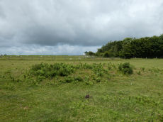
East Hill Clearance Cairn
OS Map: SX 5977 9382
HER: MDV20457
ShortName: CN East Hill
Barrow Report: 17
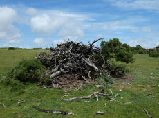
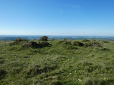
Notes: NMR suggests "Post medieval clearance". The photo is presumably of this site. It was taken not long after the platinum jubilee celebrations in 2022 when a number of beacons were contructed on Dartmoor. The assumption is this was built up on top of the clearance cairn but the quantity of material obscures whether or not there is a mound there. No other obvious clearance cairn could be found in the vicinity suggesting this is it. THE HER gives the location as SX 59770 93820 and this is at SX 59746 93844. As this identification is not certain the grid reference will be left as that given by the HER.
Nearby sites: SX 5977 9382
Distance: 0.84km
Oke Tor Reported Cist
OS Map: SX 61202 90099
HER: MDV6936
PMD: Oke Tor
ShortName: CT?OkeTor 1
Grinsell: LYD 2b
Notes: Dubious. A stone row on the western slopes of oke tor. The stone row runs a little north of west and south of east directly downhill towards the river(east okement). It is single, and runs between two large stone slabs which probably once formed part of cists, and at the further end two large stones lying prone within 2m of each other. One of the two slabs is set amidst other stones which may have formed a circle. Between the slabs is a fallen stone.(worth). Grinsell gives ngr 610-902- for apparently the same site. The cist is contained in the remains of a cairn. Not found. See also Oke Tor Reported Stone Row. Butler Vol 2 p.206.
Nearby sites: SX 61202 90099
Distance: 4.79km
Halstock Down 7 Reported Cist
OS Map: SX 5984 9224
HER: MDV60255
ShortName: CT:Halstock 7
Notes: Cairn and cist 830m S of moorgate farm. Update 13/12/2024 This was formerly listed as Moorgate Farm and marked here as a duplicate. Name changed to East Bowden 6 as appears to be part of that group. The HER record states "Location needs checking against Okehampton survey data.". The location on the HER record is nearly 0.8 km South of the Moor gate 1 record (MDV70198). East Bowden 3 (MDV60254) is around 100 metres away but has no reported cist. This suggests it may NOT be a duplicate and as such this record has been restored.
Nearby sites: SX 5984 9224
Distance: 2.30km
A30 Embankment 2 Reported Cairn
OS Map: SX 602 946
HER: MDV63885
ShortName: CNxA30Embank 2
Notes: HER: Circular mound 6m diameter x 0.3m high cut by the field boundary to the east + the railway embankment to the west. Interpreted as a cairn.
Nearby sites: SX 602 946
Distance: 1.00km
Belstone 4 Reported Cairn
OS Map: SX 6260 9303
HER: MDV64177
ShortName: CN:Belstone 4
Notes: HER: Three cairns and lengths of rubble walling on a north-facing slope overlooking Belstone Cleave.
Nearby sites: SX 6260 9303
Distance: 3.67km
Belstone 5 Reported Cairn
OS Map: SX 6247 9315
HER: MDV64179
ShortName: CN:Belstone 5
Notes: HER: Diameter measures 10.3m. Mound measures 3.8m diameter, 0.6m high. A complex site consisting of a 3.8m diameter central mound, with a 1m wide a 0.2m high rubble bank 0.9m from the foot of the mound on the e side. 2m beyond this is a 0.5m high scarp. On the w side of the mound and 2.5m from it is a slight bank measuring 1m wide and 0.2m high. This is probably a ring cairn with a central mound, although it might be a badly robbed stone hut circle.
Nearby sites: SX 6247 9315
Distance: 3.51km
Okehampton Camp Road 2 Reported Cairn
OS Map: SX 5906 9340
HER: MDV67976
ShortName: CN:CampRoad 2
Notes: HER: An earthen mound, now heavily disturbed, is most probably the remains of a prehistoric barrow. It lies on the edge of marshy ground in a slight natural silted floodplain. It measures 20m by 18m and a maximum 0.8m high. The inner core has been dug into - perhaps the product of an unrecorded excavation. Spoil from this digging has been dumped o the southern crest and edges of the mound. Apart from three small boulders on the SE side there is no visible trace of stone in the turf-covered mound.
Nearby sites: SX 5906 9340
Distance: 1.07km
South Down 2 Reported Cairn
OS Map: SX 556 912
HER: MDV12885
ShortName: CN:SouthDown 2
Notes: HER: ne of a pair of cairns on South Down, west of Meldon Reservoir.
Nearby sites: SX 556 912
Distance: 4.86km
South Down 3 Reported Cairn
OS Map: SX 55601 91239
HER: MDV12887
ShortName: CN:SouthDown 3
Notes: NGR for this record is taken from an apparent matching feature on LIDAR. HER: one of a pair of cairns on South Down, west of Meldon Reservoir..
Nearby sites: SX 55601 91239
Distance: 4.84km
South Down 4 Reported Cairn
OS Map: SX 5553 9112
HER: MDV27374
ShortName: CN:SouthDown 4
Notes: HER: Barrow on south-west slope of South Down visible on RAF 1947 aerial image at SX 5553 9112.
Nearby sites: SX 5553 9112
Distance: 4.97km
West Mill Tor Reported Cairn
OS Map: SX 5898 9060
HER: MDV103614
ShortName: CN:West Mill
Notes: HER: Two small cairns at SX 58989060 and SX 58989059 and a short length of a low, spread boulder/stone bank indicate stone clearance activity. Whether the amorphous bank was intended to be the start of a newtake bank is not clear. (It extends from SX58959059 to SX 59069059).
Nearby sites: SX 5898 9060
Distance: 3.86km
South Down 1 Reported Cairn
OS Map: SX 5587 9140
HER: MDV12883
ShortName: CN:SouthDown 1
Notes: Presumed prehistoric cairn on the north end of South Down
Nearby sites: SX 5587 9140
Distance: 4.53km
Skaigh Warren 1 Reported Cairn
OS Map: SX 633 936
HER: MDV13052
ShortName: CN?SkaighWa 1
Notes: "Many small cairns situated on the natural terrace here. Possible prehistoric cairn group."
Nearby sites: SX 633 936
Distance: 4.17km
Skaigh Warren 2 Reported Cairn
OS Map: SX 637 936
HER: MDV13053
ShortName: CN?SkaighWa 2
Notes: "Many small cairns within modern enclosure here. Possibly the result of field clearance but quite likely to be a group of prehistoric cairns."
Nearby sites: SX 637 936
Distance: 4.57km
Cosdon Hill N.W.1 (c.8+) Cairnfield Master
OS Map: SX 629 927
HER: MDV14436
ShortName: CN:CosdonNWCFM
Butler map: 40.10
Notes: Cairnfield on Cosdon Hill, consisting of at least eight cairns.
Nearby sites: SX 629 927
Distance: 4.08km
Belstone M Cairnfield Master
OS Map: SX 626 930
HER: MDV64176
ShortName: CN:Belstone M
Notes: HER A cairnfield adjacent to a prehistoric settlement 780 metres south-east of Belstone parish church.
Nearby sites: SX 626 930
Distance: 3.69km
Halstock Down Cairnfield Master
OS Map: SX 5959 9214
HER: MDV58789
ShortName: CN:Halstock M
Notes: HER: A cluster of 34 small clearance cairns and fragments of an apparently contemporary field system lie on the western flank of Halstock Down adjacent to the military ring road. The cairns vary in size from 1.7 metres to 6.9 metres in diameter and stand between 0.25 and 0.6 metres high. The majority (25) of these features are sub-circular, the remainder being definitely ovoid or linear in plan. One example is square. Bank fragments are now thought to be from the later prehistoric or even historic period and may not indicate fields
Nearby sites: SX 5959 9214
Distance: 2.35km
Black Down W. Platform Cairn Circle and Cist
OS Map: SX 57398 91540
HER: MDV61332
Megalithic Portal: 45801
PMD: Black Down
ShortName: CT:BlackDown W
Butler map: 42.6
Butler Vol 5: p.58 & Fig.35
Notes: Not located at SX 57409153 on 28/08/16. Butler SX57389153. NMR SX57469153."The cairn is 6 metres in diameter and 0.7 metres in height. The cist is 0.9 metres long with 2 end stones in the original position. Remains of a kerb are visible around the north west edge of the mound". 1.6km east of Higher Bowden. nb. Not listed by Turner - assigned as "Platform Circle" type cairn due to description in NMR. "A flat-topped cairn". Butler Black Down W. Vol. 2. Map 42.6 (diagram Vol 5. p.58).
Nearby sites: SX 57398 91540
Distance: 3.44km
Blackaven Brook Cairn
OS Map: SX 60117 91909
HER: MDV59588
Alternate name: Harter Hill Cairn
ShortName: CN:Blackaven
Butler map: 42.4
Nearby sites: SX 60117 91909
Distance: 2.70km
Cosdon Hill Encircled Cairn
OS Map: SX 63350 92479
HER: MDV13064
Megalithic Portal: 22695
Alternate name: Cosdon Hill N.4 Encircled Cairn
ShortName: EC Cosdon N4
Butler map: 40.9
Grinsell: ST 10
Notes: Cairn at the junction of two Bronze Age reaves. "Round cairn on Cosdon Hill, measuring 7.3 metres in diameter and standing up to 0.8 metres high. A number of edge set stones visible around the southern side of the cairn mound suggests the existence of a kerb. There is a hollow in the north side of the mound, probably the result of partial robbing or an early excavation."
Nearby sites: SX 63350 92479
Distance: 4.58km
Cosdon Hill (West) Enclosed Settlement
OS Map: SX 63078 91486
HER: MDV52466
ShortName: ES:CosdonW
Notes: HER: Southern of two settlement to the south-west of Cosdon Hill of 86 metres by 56 metres with at least three enclosed areas and at least eleven hut circles. A short distance to the north is a second settlement, see MDV6920. Three or four adjoining enclosures to the south-west of Cosdon Hill with seven associated hut circles. A diagram of these enclosures can be found in Gerrard (1997), diagram 29 p.50.
Nearby sites: SX 63078 91486
Distance: 4.87km
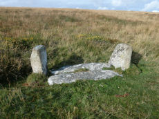
Cullever Steps Ring Setting Cairn and Cist
OS Map: SX 60787 91954
HER: MDV6867
Megalithic Portal: 17956
PMD: Cullever Steps
ShortName: CT Cullever
Butler map: 40.14
Butler Vol 5: p.181 & Fig.123
Grinsell: BEL 2
Turner: D11
Notes: "A Bronze Age ring cairn situated below Belstone Tor within the valley of the East Okement River. The cairn survives as a 0.5 metre high bank surrounding a 4.1 metre diameter internal area. The bank around the southern and eastern side of the cairn is faced on both sides with edge set stones. A large flat stone lying on the south western part of the ring bank may represent a displaced cist coverstone. The overall dimensions of the cairn are 9.5 metres east to west by 8.5 metres north to south." Butler Vol. 2. Map 40.14 (diagram Vol. 5. p.181).
Nearby sites: SX 60787 91954
Distance: 2.96km

East Hill Fort
Prehistoric Dartmoor Walks: Dartmoor Resource: Table of Devon Iron Age Forts
OS Map: SX 60397 94162
HER: MDV6880
Megalithic Portal: 47073
ShortName: FT East Hill
Notes: "A promontory fort of likely Iron Age date containing a further, probably earlier, enclosure. It occupies an elevated position at the tip of the spur between the East Okement River and the Moor Brook. The southern and eastern sides of the site are formed by precipitous slopes that fall into wooded gorges while the west and northwest are delimited by a well-defined rampart and ditch pierced by a single entrance. The highest point within the fort, the SE quadrant, is occupied by the earlier enclosure which does not possess an entrance. Traces of ridge and furrow are visible in the southern part of the interior."
Nearby sites: SX 60397 94162
Distance: 1.22km
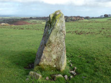
Halstock Standing Stone
OS Map: SX 60461 93334
HER: MDV13056
ShortName: SS Halstock
Notes: HER: Small standing stone north of East Bowden, near three prehistoric cairns. Gerrard p.63: There are possible standing stones at Halstock and Butterdon Down. Two of the cairns (East Bowden 2 and 3) align on the stone.
Nearby sites: SX 60461 93334
Distance: 1.68km
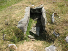
Homerton Hill N. Cist
OS Map: SX 56132 90651
HER: MDV12884
Megalithic Portal: 45808
PMD: Homerton Hill
ShortName: CT Homerton N
Butler map: 43.15
Butler Vol 5: p.177 & Fig.119
DPD page: 157
Notes: Butler Homerton Hill N. Vol. 2. Map 43.15 (diagram Vol. 5. p.177). A small, disturbed cairn containing three edge set stones of a cist ... The turf covered cairn measures 3.5 x 3.1m and 0.3m max. height. The top and north side of the mound has been disturbed exposing the three in situ cist stones. The cist measures 0.8 x 0.6m and 0.3mdeep. It is now open to the north. A large stone lying flush with the ground lies immediately north east of the cairn and probably represents the missing endstone or the coverstone. Lethbridge diagram p.156 and photos p157.
Nearby sites: SX 56132 90651
Distance: 4.90km
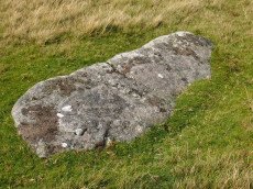
Longstone Hill Standing Stone
OS Map: SX 56725 90890
HER: MDV5571
Megalithic Portal: 36422
PMD: Longstone Hill Standing Stone
ShortName: SS Longstone
Butler map: 42.
Butler Vol 5: p.220
DPD page: 156
Notes: Possible recumbent longstone on summit of Longstone Hill, east of Meldon Reservoir. Suggested as possible menhir by Butler and Newman. Historic England:A sinuous 50 metres long, 2 metres wide and 0.25 metres high bank lying within the monument leads towards a large recumbent stone. This stone measures 1.75 metres long, 0.8 metres wide and 0.45 metres thick and is the only large stone visible on Longstone Hill. It has been suggested that this may be the longstone which once stood upright to give the hill its name. The presence of this stone, which would have been broadly contemporary with the cairns, provides additional support for the ritual and funerary character ascribed to many cairns within the group.
Nearby sites: SX 56725 90890
Distance: 4.35km
Metheral Stone Circle
OS Map: SX 62049 90436
Megalithic Portal: 61225
ShortName: SC:Metheral
Nearby sites: SX 62049 90436
Distance: 4.92km
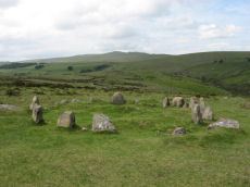
Nine Stones, Belstone Cairn Circle
Prehistoric Dartmoor Walks: Dartmoor Site: Nine Maidens Cairn Circle, Belstone Tor
OS Map: SX 61232 92849
HER: MDV6865
Megalithic Portal: 535
PMD: The Nine Stones
Alternate name: Nine Stones Cairn Circle
ShortName: CC Nine Stones
Butler map: 40.13
DPD page: 156
Grinsell: BEL 1
Turner: G23
Barrow Report: 21 42
Notes: The "Nine Stones" cairn circle "survives as a ring of at least 16 upright stones, standing up to 0.7 metres high, surrounding a slightly raised 7 metre diameter internal area". "A loose granite boulder in the centre of the circle may cover a cist; and there are vestiges of a mound around it. Well preserved."
Nearby sites: SX 61232 92849
Distance: 2.58km
Oke Tor Reported Stone Row
OS Map: SX 61202 90099
HER: MDV4375
PMD: Oke Tor
ShortName: SR?OkeTor
Notes: Dubious. A stone row on the western slopes of oke tor. The stone row runs a little north of west and south of east directly downhill towards the river(east okement). It is single, and runs between two large stone slabs which probably once formed part of cists, and at the further end two large stones lying prone within 2m of each other. One of the two slabs is set amidst other stones which may have formed a circle. Between the slabs is a fallen stone.(worth). Grinsell gives ngr 610-902 for apparently the same site. The cist is contained in the remains of a cairn. Not found. NB. This record is duplicated here as a reported stone row. It is also duplicated on the HER. See also: Oke Tor Reported Cist Butler Vol 2 p.206.
Nearby sites: SX 61202 90099
Distance: 4.79km
Watchet Hill Cairn
OS Map: SX 61477 93055
HER: MDV13049
Megalithic Portal: 23222
ShortName: CN WatchetHill
Butler map: 40.12
Grinsell: BEL 3
Notes: "A Bronze Age round cairn situated on the summit of Watchet Hill. The cairn survives as a 0.8 metre high oval mound measuring 16.6 metres long north to south by 13.8 metres wide east to west. A T-shaped trench, the consequence of a partial early excavation, cuts through the central part of the mound. Adjacent to the south eastern side of the mound there is a 2.3 metre wide and 0.2 metre deep ditch. This represents the remains of the quarry ditch from which material was derived during the construction of the cairn. The ditch would have originally surrounded the mound but now survives largely as a buried feature."
Nearby sites: SX 61477 93055
Distance: 2.66km

West Mill Tor Reported Stone Row
OS Map: SX 5878 9078
HER: MDV11812
ShortName: SR:West Mill
Notes: HER: A double stone row thought to be of prehistoric date comprises 35 surviving stones, of which 7 are recumbent. The original arrangement may have included 64 stones. They now stand at a distance of 9m between rows as slabs set on edge and in line averaging 0.15m thick, 0.5m long and 0.4m high. A sinuous double row of set stones lies across the summit area of a moorland ridge. Its origins and function are obscure but it may be associated with military activity, possibly a trackway.
Nearby sites: SX 5878 9078
Distance: 3.70km
Winter Tor Cist
OS Map: SX 61112 91352
HER: MDV6881
Megalithic Portal: 45779
PMD: Winter Tor
Alternate name: Higher Tor S.1 Cist
ShortName: CT HigherTor 1
Butler map: 40.15
Butler Vol 5: p.169 & Fig.108
Grinsell: LYD 1
Notes: [Formerly listed as Higher Tor (S), renamed after PMD] Butler Higher Tor (S) Vol. 2. Map 40.15. (diagram Vol. 5. p.169). Ths cist was excavated by Prowse as described in his article of 1890. About 300 yards south-south-east of Winter Tor is a tumulus diameter 9 yards and height 3 feet, the top of which has been hollowed out. Within the hollow was a granite slab 4 feet 6 inches by 2 feet 9 inches, covering the remains of a cist, and another slab approximately 4 feet 9 inches by 3 feet 3 inches, either a second capstone or possibly part of the first cist. The cist contained nothing of interest except a few small porous and very brittle fragments of what is apparently bony tissue. After examination the capstone was replaced and covered with soil and stones.
Nearby sites: SX 61112 91352
Distance: 3.64km
Yes Tor E Cairn
OS Map: SX 58044 90185
HER: MDV4814
Megalithic Portal: 36416
Alternate name: Yes Tor 2 Cairn
ShortName: CN Yes Tor E
Butler map: 42.1.2
Grinsell: OKE 2
Notes: One of two cairns on Yes Tor. On the top of the flat outcrop of Yes Tor and piled against the west side is an amorphous mass of stones representing a ruined cairn. The patch of stones on the top is more or less 14.0m across and 0.3 m high and the piling against the outcrop is 2.3m high. It is possible that this has resulted from bulldozing the cairn over the side of the outcrop but the stones appear quite stable and compacted.
Nearby sites: SX 58044 90185
Distance: 4.43km
Yes Tor W Cairn
OS Map: SX 57955 90210
HER: MDV4813
Megalithic Portal: 36416
Alternate name: Yes Tor 1 Cairn
ShortName: CN Yes Tor W
Butler map: 42.1.1
Grinsell: OKE 1
Notes: Western of two round barrows on the summit of yes tor. About 36.6m nw of flag staff on the top of yes tor is an incomplete ring of rough granite boulders varying in size but generally 0.3m - 0.9m. Long. The ring is about 6.1m long and is defective on the north east side where there is evidence of a slightly sunken trackway. In the interior of this ring the ground is slightly irregular and contains blocks of granite. At the south western part of the circle a smaller circle of stones abuts on the previous circle. Butler Volume 2 Map 42.1.
Nearby sites: SX 57955 90210
Distance: 4.43km