
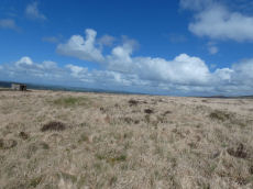
Prehistoric sites within 2km of SX 52760 85040
Guidance for walkers: The monuments featured in this database are archaeological treasures and need to be protected and preserved - please do not disturb any sites. Please check access and firing times before visiting sites, not all sites listed are on open access land. Firing ranges and boundaries of open access areas are marked on the OL28 OS Dartmoor Explorer map. Please stick to the country code and consider giving support to the numerous agencies that help to keep Dartmoor a fabulous natural and historic environment!
About the database listings: In all listings clicking on the photo or the site name will open a page for the site with a larger photo and further details from the database. The database now has over 6680 records covering nearly all publicly listed sites on Dartmoor including around 4800 round houses. This level of detail is of interest to archaeologists but tends to swamp listings of sites more likely to be of interest for walkers. For this reason, the listings default to around 550 core sites only. These are the stone circles, stone rows and the ring cairns listed by Turner. The default search radius is 2 km. The controls below the map can be used to start a new search by entering a 6- or 8-digit reference (without the prefix "SX"). The search radius can be specified and you can add incremental Display layers of detail on top of the core sites. If using a more detailed layer you will need to decrease the search radius to avoid getting hundreds of search results.
- Core sites Default listing of core sites consisting of stone circles & rows and some of the major ring cairns.
- Plus cairns adds approx. 1000 cairns and other minor sites not included in the core listings but excluding round houses.
- Plus round houses adds approx. 4800 round houses.
- Plus non-sites adds in the records for sites that no longer exist or are not prehistoric sites.
- Plus duplicates adds records excluded as duplicates. Those maybe duplicate records in external listings (e.g. the Historic Environment Records). For example, some sites have been identified as cairns in some listings and interpreted as round houses in other listings and both records appear.
These listings have incorporated, matched up and merged all of the records from all of the major archaeological listings including: Worth, Grinsell, Turner, Butler, Bill Radcliffe, Sandy Gerrard, Megalithic Portal, the National Monument Records and the Historic Environment Records. The author would like to thank Bill, Sandy, the lovely people both at Megalithic Portal (especially Anne Tate who did an amazing job to link listings) and at ACE Archaeology for collaborative work over the years to synchronise and correct listings across the various websites which now interlink. A culmination of years of work the final merger of cairn records took 3 months of cross referencing in 2017 the result being a snapshot of the records at that time. This data has in turn been refined since by field work and research. The round house data was supplied by Sandy Gerrard. Grid references are in order of accuracy: from Google Earth satellite, if visible and found, from a Garmin GPS reading, if visited by the author and from the literature otherwise. Individual site pages will state the source of the grid reference and provide satellite imagery. If a site listing lacks a photo it has not yet been visited by the author in which case the grid reference is from the literature.
Currently the database only includes sites which can be represented by a grid reference. Reaves are not included as they require GIS shape technology which is beyond the current capability of this system. To see the sources for the records, look at the tables on the resources menu. The database listings can also be viewed on a Google map and downloaded as GPS datasets for Garmin devices.
Corrections, or any feedback or suggestions are very welcome, email: info@dartmoorwalks.org.uk.
NOTE: Clicking on the icons for each monument in the map will give the name of the site. You can zoom in and out and drag the map around.
List of sites within 2km of SX 52760 85040
White Hill S.W.11 Stone Ring Cairn Circle
OS Map: SX 5316 8377
HER: MDV103627
ShortName: RC WhiteHiSW11
Notes: HER: Probable ring cairn measuring 5.7 metres in diameter by 0.3 metres high composed of sandstone and slate stones. One of a scattered group of cairns located below the summit area of White Hill at 380 metres above OD.
Nearby sites: SX 5316 8377
Distance: 1.33km
White Hill S.W.12 Stone Ring Cairn Circle
OS Map: SX 5295 8386
HER: MDV103629
ShortName: RC WhiteHiSW12
Notes: HER: Disturbed ring cairn measuring 6.0 metres in diameter by 0.3 metres high composed of sandstone and slate stones with a gap in the north-west side. One of a scattered group of cairns located below the summit area of White Hill at 380m above OD.
Nearby sites: SX 5295 8386
Distance: 1.20km
White Hill N.E. (c.24) Cairnfield Master
OS Map: SX 535 840
HER: MDV14428
ShortName: CN:WhiteHill N
Butler map: 32.22.12
Grinsell: PET 10
Notes: Cairn field. Difficult to identify relevant HER record. The HER number (14428) linked gives a listing of the HER records of cairns in this area. The HER record 51457 gives the OS grid reference and description of 13 cairns.
Nearby sites: SX 535 840
Distance: 1.28km
White Hill S.W.1 Stone Ring Cairn Circle
OS Map: SX 52941 83690
HER: MDV21078
Megalithic Portal: 45821
ShortName: RC WhiteHiSW 1
Butler map: 32.22.1
Grinsell: PET 1
Turner: A8
Notes: HER: Cairn of 15 metres diameter with a bank 3.5 metres wide by 0.5 metres high within cairn cemetery to the south-west of White Tor. Central hollow 6 metres long by 1.7 metres wide by 0.3 metres deep and The earthwork appears as a raised internal platform measuring 15m in diameter surrounded by a circular bank 3.5m wide and 0.5m high. A shallow hollow in the centre of the internal area suggests robbing or partial early excavation.
Nearby sites: SX 52941 83690
Distance: 1.36km

White Hill S.W. Cairn Alignment
OS Map: SX 52941 83690
HER: MDV50152
Megalithic Portal: 45821
ShortName: CR WhiteHiSW
Notes: A linear arrangement of 6 large cairns. Another two result in an L-shape. Butler: The cairn cemetery to the south-west of White Hill includes eight cairns laid out in an L-shape. Three were excavated by Baring-Gould in around 1888. Despite their comparatively large size he only found a shallow pit dug into the subsoil at the centre of each containing charcoal and ashes.
Nearby sites: SX 52941 83690
Distance: 1.36km
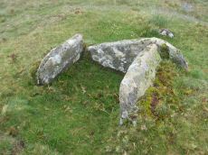
Doe Tor Cist
OS Map: SX 54383 84846
HER: MDV3251
Megalithic Portal: 44223
PMD: Doe Tor
Alternate name: Doe Tor E. Cist
ShortName: CT Doe Tor
Butler map: 32.21
Butler Vol 5: p.198 & Fig.141
DPD page: 10
Grinsell: LYD 12
Barrow Report: 24
Notes: Butler Doe Tor E - Vol. 2. Map 32.21 (diagram Vol. 5. p.198).
Nearby sites: SX 54383 84846
Distance: 1.63km

White Hill Cist
OS Map: SX 53717 84201
HER: MDV3216
Megalithic Portal: 45783
PMD: White Hill NE.
Alternate name: White Hill N.E.1 Cist
ShortName: CT WhiteHiNE 1
Butler map: 32.22.10
Butler Vol 5: p.217 & Fig.151
DPD page: 11
Grinsell: PET 11
Notes: HER: Round cairn of 9.0 metres diameter by 0.5 metres high with a cist overlooking Walla Brook. A hollow in the centre of the mound, suggests previous robbing or partial excavation. Within the hollow, and situated on the south side, is a stone cist. The two end stones and the southern side stone are still in their original position.
Nearby sites: SX 53717 84201
Distance: 1.27km