
Cholwich Town Stone Row
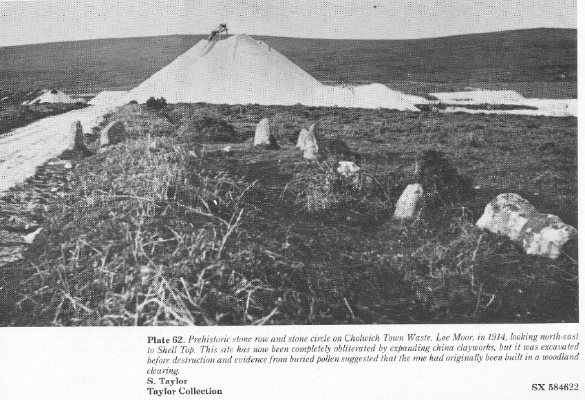
Photo taken on 31-12-1914
Database entries
OS Map: SX 585 623
OS Source: SRGB
HER: MDV2438
Megalithic Portal: 1824
The Stone Rows of GB: Cholwichtown
PMD: Cholwich Town Stone Row
Alternate name: Cholwichtown stone row
Short Name: SRxCholwich
Butler map: 48.7
Exist: No
Record: Unique
Record Source: PDW
Hut Class: No
Dimensions (m): 217
Lidar: SX 585 623
Guide Map: 54
Nearest Bus Stop: Lee Moor Clearview (1.7 km) [Route: 59]
Nearby sites: SX 585 623
Notes
"This ring and stone row is now covered by china clay waste. A stone row and circle on top of a low ridge, between Tory Brook and a tributary of the Yealm, near Cholwich Town. The row, extending over 700ft, consisted of uprights 2-3ft. high and 3ft. apart, the circle, at the northern end of the row, was 15ft. in diameter with seven upright stones. The site was excavated in 1961, and the sockets of many missing stones were found, also a pit 8ft. in diameter in the centre of the circle." Pollen analysis suggested the row was originally in a clearing of a wooded area.The photo reproduced here originates from the Megalithic Portal and was uploaded there by Angie Lake in 2015 with this description: This image from 1914 shows the prehistoric stone row and circle that once stood here at Cholwich Town Waste on Lee Moor. Excavation done prior to its destruction unearthed buried pollen that suggested the row had originally been built in a woodland clearing. (c) S. Taylor, the Taylor Collection. Copied from 'A Dartmoor Century 1883-1983. One hundred years of the Dartmoor Preservation Association.'
References
These are selected references with an emphasis on out of copyright sources linked as PDFs. For more detailed references try any linked HER or PMD record above.
- Butler, Jeremy, Dartmoor Atlas of Antiquities, vol.3: The South-West, (1994)
- Crossing, William, Guide to Dartmoor, (2001)
- Davidson, C. & Seabrook, R., Stone rings on south-east Dartmoor, D.A.S.P. No.31 (1973)
- Emmett, D.D., Stone rows: the traditional view reconsidered, D.A.S.P. No.37 pp.94-114 (1979)
- Eogan, George and Simmons, I.G., The Excavation of a Stone Alignment and Circle at Cholwichtown, Proceedings of the Prehistoric Society , Volume 30 , pp. 25 - 38 (1964)
- Fox, Aileen, 27th Report on Archaeology and Early History, T.D.A. Vol.95 pp.74-86 (1963)
- Gerrard, Sandy, English Heritage Book of Dartmoor: Landscapes Through Time, (1997)
- Rowe, Samuel, A Perambulation of Dartmoor (3rd Edition), (1896)
- Simmons, I. G., Pollen diagrams from Dartmoor, New Phytologist 63, 165-180 (1964)
- Simmons, I. G., Environment and Early Man on Dartmoor, Proceedings of the Prehistoric Society , Volume 35 , pp. 203–19 (1969)
- Somer Cooks J.V., A Dartmoor Century 1883-1983, (1983)
- Worth, R. Hansford, The Erme, Yealm and Torry part 1, T.P.I. Vol.11 part 1 pp.173-183 (1892)
- Worth, R. Hansford, The Stone Rows of Dartmoor Part 1, T.D.A. Vol.78 pp.285-316 (1946)
- Worth, R.N., The Stone Rows of Dartmoor - Part 1, T.D.A. Vol.24 pp.387-417 (1892)