
Lakehead Hill S.W. Stone Row
Worth, R. Hansford (1946)
Database entries
PDW coverage: Dartmoor Site: Lakehead Hill
OS Map: SX 6436 7722
OS Source: Worth
Butler OS: SX64187730
HER: MDV5844
Megalithic Portal: 45595
PMD: Lakehead Hill 6 Stone Row
Alternate name: Lakehead Hill S.W.
Short Name: SR:Lakehead SW
Butler map: 27.19.1
Exist: Maybe
Record: Unique
Record Source: PDW
Hut Class: No
Lidar: SX 6436 7722
Guide Map: 28
Nearest Bus Stop: Postbridge Bellever (1.6 km) [Route: 98]
Nearby sites: SX 6436 7722
Notes
HER: Alleged Stone row recorded in 1946 but covered by a forestry plantation in 1979. At that time, 3 stones were visible, but it was uncertain whether they were part of the stone row. It may have been destroyed or covered by humus. Butler: Worth records a stone row on the south-west side of Lakehead Hill but this area has been overplanted and nothing can now be seen. The row was about 123 metres long orientated to the north-east and without any associated cairn.(07/09/2026) This record formerly used the grid reference SX 6418 7730 which originated with Butler. This is approx 200 metres NW of the location given by Worth in 1946 which is SX 6436 7722. This record is being reverted to the original grid reference when the site was recorded.
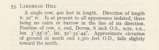
R.H. Worth (1946): A single row, 400 feet in length. Direction of length N. 220 W. Is at present to all appearance isolated, there being no cairn or barrow in the line of its direction. Position of row, s. end, Devon, 6 inch O.S., xcix, s.e., lon. 3 55' 2", lat. 50 34' 44". Approximate elevation of ground at south end 1300 feet O.D., falls slightly toward the north.
R.N. Worth (1895): On top of the hill is a line of stones running W.N.W. and E.S.E. for 100 ft. ; stones small, at even intervals. How much further not examined. End stone at right angles. This row is very doubtful. We suspect it formed an old boundary, as there are faint indications of another line at right angles to it, and because the stones have not the customary pits and "triggers." Anyhow, it is a doubtful line.
References
These are selected references with an emphasis on out of copyright sources linked as PDFs. For more detailed references try any linked HER or PMD record above.
- Butler, Jeremy, Dartmoor Atlas of Antiquities, vol.2: The North, (1991)
- Emmett, D.D., Stone rows: the traditional view reconsidered, D.A.S.P. No.37 pp.94-114 (1979)
- Worth, R. Hansford, The Stone Rows of Dartmoor Part 1, T.D.A. Vol.78 pp.285-316 (1946)
- Worth, R.N., The Stone Rows of Dartmoor - Part 4, T.D.A. Vol.27 pp.437-442 (1895)