
Western White Barrow (SE of) Stone Ring Cairn Circle
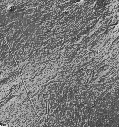
Feature can be seen on LIDAR.
Database entries
OS Map: SX 65524 65290
OS Source: Google
HER: MDV39431
Alternate name: Western White Barrow (SE of)
Short Name: RC:SE Western
Exist: Yes
Record: Unique
Record Source: HER
Hut Class: No
Cairn Class: Yes
Dimensions (m): 21-22
Lidar: SX 65524 65290
Guide Map: 52
Nearest Bus Stop: South Brent Pool Park (9.2 km) [Route: 38]
Nearby sites: SX 65524 65290
Notes
NGR for this record was previously estimated from 6-digit figure given in HER at SX 6553 6524 but more accurate LIDAR NGR now used. HER Circular ring of small stones measuring between 21-22 metres in diameter with a possible entrance. Located approximately 250 metres south-east from the Western White Barrow.The author tried to find this feature at SX 6553 6524 on 08/08/2026. The area had a dense cover of molinia and given the NGR was an inaccurate estimate it could not be found. Looking at the area on LIDAR afterwards it can clearly be seen at SX 65524 65290. The author had been around 50 metres away. NGR now updated.
The LIDAR image shows the Western White Barrow in the top left-hand corner and centred in the image a small ring can be seen. It can also be seen clearly on Google satellite.