
Cripdon Down Reported Stone Row
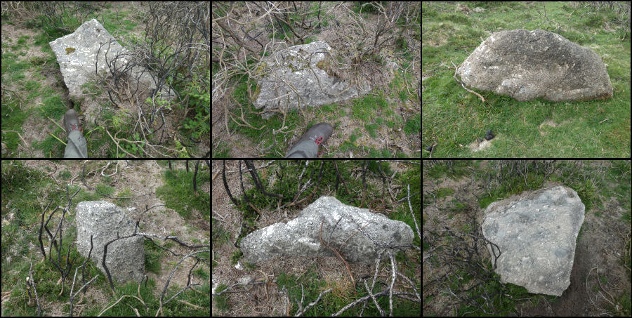
Photo taken on 06-05-2026
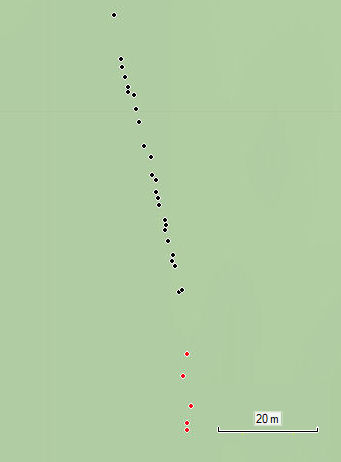
Plan of the stones in the Cripdon Down reported row.
Database entries
OS Map: SX 73362 80749
OS Source: Garmin
HER: MDV130912
PMD: Cripdon Down
Alternate name: Cripdon Down
Short Name: SR Cripdon
Exist: Maybe
Record: Unique
Record Source: HER
Hut Class: No
Cist Class: Maybe
Lidar: SX 73362 80749
Guide Map: 30
Nearest Bus Stop (Minor): Manaton Bus Shelter (2.2 km) [Route: 271,671]
Nearest Bus Stop (Major): Lustleigh Eastwrey Barton Hotel (5.2 km) [Route: 178,171(20/07/26 to 19/09/26)]
Nearby sites: SX 73362 80749
Notes
HER: Hemery (1983) records a stone row here, estimated at SX 735 808. Stone row, Cripdon Down. North-west of the hut circles depicted on the Ordnance Survey map (SX 78 SW 17) and west of the Cripdon Down summit pile is a single stone row, 120 yards long passing over the crest of the Down. At the northern end is a very large fallen slab (destroyed cist?). The lower, southern end has stones of a greater size than the majority, one 7 feet long could have former a blocking stone. The stones are evenly spaced and not generally large.Hemery pp.724-5: Another unrecorded feature on the down, one of considerable interest, lies west of the summit pile: this is a single stone row 120 yards in length, aligned approximately north-south and passing over the crest of the down, as does Staldon row. At the northern end is a very large fallen slab, possibly a relic of a destroyed grave. The lower (southern) end has stones of greater size than the majority, which are mostly prostrate; one seven foot in length, could have formed a blocking stone. The smaller stones typical of the greater length of the row, most of them still standing, are in general evenly spaced, but a vigorous growth of furze on the hill crest prevents anything more than a superficial examination of remaining stones.
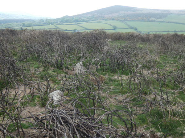
The author looked for this feature with Steve Szypko on 06/05/2026. The estimated grid reference SX 735 808 on the HER is to the north of the Cripdon Down summit pile. We assumed the grid reference was wrong and looked to the west and very quickly found a row of stones. It is to be found in an area overgrown with gorse which had recently been burnt back.
There are around 29 stones between SX 73362 80749 and SX 73376 80694 which are on a fairly straight line. There are another 5 between SX 73376 80681 and SX 73376 80666 which are marked in red on the plan.
Some of the stones look like plausible stones of a stone row, see photo montage above (boot in some pics for scale - the stones are reasonably large). Other stones look more typical of stones deposited to form the basis of a reave. The way the additional stones in red on the plan curve off the straight line is suggestive of this feature being a reave or the foundation for a reave. There is no indication of any terminal cairns or structures. If the feature is a reave it has mostly been reduced to the stones with no banking remaining along it's length.
This row of stones cannot be seen on Lidar but reaves can be seen very close that run parallel to it. The stones in the plan run at at 165 degrees true as does the section of reave on the RHS of this image.
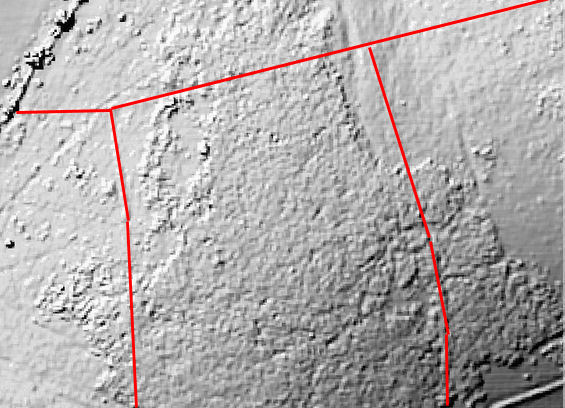
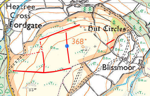
On Map 21 Butler (p.107) shows some reaves on Cripdon Down. The following plan indicates the location of those reaves, as shown by Butler (marked up in red). The blue dot on the plan is the precise location of northern end of this row of stones and it is right in the middle of one of these reaves.
Bill Radcliffe's Prehistoric Monuments of Dartmoor (PMD) entry for this reported row mentions correspondence In Dartmoor Magazine 51 (Summer 1998) p32, 52 (Autumn 1998) p36.
There had been swaling on Cripdon Down in 1998 which had exposed these stones much like they had for our visit. Tim Jenkinson (Issue 51) noted that Hemery had described them as a stone row and asked what readers thought. Murray Oates replied (Issue 52): can I be so bold as to suggest it isn't a row but it is either an unfinished reave, or a 'marking out line' for a more substantial boundary.
We independently reached the same conclusion as Murray Oates. Sandy Gerrard includes this site in the gazetteer of rows that are Dubious, Uncertain and Unlikely with the simple summary of "Confusion, Not".
References
These are selected references with an emphasis on out of copyright sources linked as PDFs. For more detailed references try any linked HER or PMD record above.
- Butler, Jeremy, Dartmoor Atlas of Antiquities, vol.1: The East, (1991)
- Hemery, Eric, High Dartmoor: Land and People, (1983)