
Clovelly Dykes Fort

Plan: J.C. Wall in Ancient Earthworks (1906)
Database entries
PDW coverage: Dartmoor Resource: Table of Devon Iron Age Forts
OS Map: SS 31140 23462
OS Source: Google
HER: MDV169
Megalithic Portal: 4601
Alternate name: Clovelly Dykes
Short Name: FT:Clovelly
Exist: Yes
Record: Unique
Record Source: Fox
Hut Class: No
Lidar: SS 31140 23462
Nearby sites: SS 31140 23462
Notes
HER: One of the largest and most impressive Early Iron Age hillforts in Devon. It is a complex series of earthworks covering more than 8.09 hectares, forming four zones of outworks with restricted entry, suggesting segregation of the herds for milking, or for autumn slaughter. The enclosures are visible on aerial photographs between 1946 and 2007, although scrub growth obscures the earthworks on many. Several new breaches of the hedgebanks were visible between the 1950s and 1970s. Ditches and banks immediately to the south of the hillfort are visible as cropmarks and earthworks on aerial photographs between 1947 and 1986, and may depict the original extent of the outer enclosures.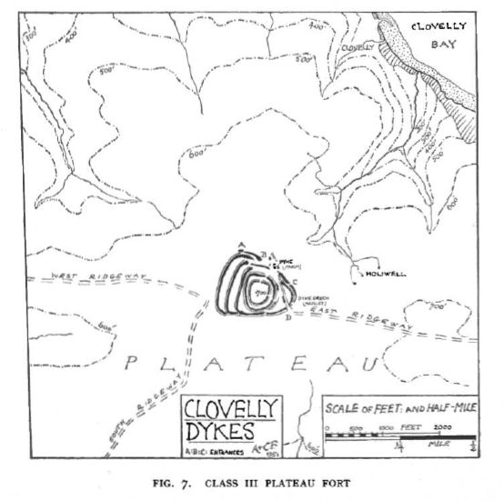
Fox (1952): The original fort consists of a double concentric enclosure with ramparts 30.48 metres apart and entered from the east. It was later enlarged by three rectangular strip-like enclosures in the west side, linked to a semi-circular enclosure on the east side. A new screened entrance to the outworks was constructed on the north west, where the ends of the ramparts flanking the entries are knobbed. Three separate entrances made into the outer enclosures (a,b and c on Fox's plan).
References
These are selected references with an emphasis on out of copyright sources linked as PDFs. For more detailed references try any linked HER or PMD record above.
- Fox, Aileen, Hill-Slope Forts and Related Earthworks in South-West England and South Wales, Archaeological Journal Vol 109 (1952)
- Fox, Aileen, Prehistoric hillforts in Devon, (1996)
- Wall, J. Charles, Ancient Earthworks, The Victoria History of the County of Devon: v. 1 pp.573-630 (1906)