
Prehistoric sites within 2km of SX 54610 66800
Guidance for walkers: The monuments featured in this database are archaeological treasures and need to be protected and preserved - please do not disturb any sites. Please check access and firing times before visiting sites, not all sites listed are on open access land. Firing ranges and boundaries of open access areas are marked on the OL28 OS Dartmoor Explorer map. Please stick to the country code and consider giving support to the numerous agencies that help to keep Dartmoor a fabulous natural and historic environment!
About the database listings: In all listings clicking on the photo or the site name will open a page for the site with a larger photo and further details from the database. The database now has over 6680 records covering nearly all publicly listed sites on Dartmoor including around 4800 round houses. This level of detail is of interest to archaeologists but tends to swamp listings of sites more likely to be of interest for walkers. For this reason, the listings default to around 550 core sites only. These are the stone circles, stone rows and the ring cairns listed by Turner. The default search radius is 2 km. The controls below the map can be used to start a new search by entering a 6- or 8-digit reference (without the prefix "SX"). The search radius can be specified and you can add incremental Display layers of detail on top of the core sites. If using a more detailed layer you will need to decrease the search radius to avoid getting hundreds of search results.
- Core sites Default listing of core sites consisting of stone circles & rows and some of the major ring cairns.
- Plus cairns adds approx. 1000 cairns and other minor sites not included in the core listings but excluding round houses.
- Plus round houses adds approx. 4800 round houses.
- Plus non-sites adds in the records for sites that no longer exist or are not prehistoric sites.
- Plus duplicates adds records excluded as duplicates. Those maybe duplicate records in external listings (e.g. the Historic Environment Records). For example, some sites have been identified as cairns in some listings and interpreted as round houses in other listings and both records appear.
These listings have incorporated, matched up and merged all of the records from all of the major archaeological listings including: Worth, Grinsell, Turner, Butler, Bill Radcliffe, Sandy Gerrard, Megalithic Portal, the National Monument Records and the Historic Environment Records. The author would like to thank Bill, Sandy, the lovely people both at Megalithic Portal (especially Anne Tate who did an amazing job to link listings) and at ACE Archaeology for collaborative work over the years to synchronise and correct listings across the various websites which now interlink. A culmination of years of work the final merger of cairn records took 3 months of cross referencing in 2017 the result being a snapshot of the records at that time. This data has in turn been refined since by field work and research. The round house data was supplied by Sandy Gerrard. Grid references are in order of accuracy: from Google Earth satellite, if visible and found, from a Garmin GPS reading, if visited by the author and from the literature otherwise. Individual site pages will state the source of the grid reference and provide satellite imagery. If a site listing lacks a photo it has not yet been visited by the author in which case the grid reference is from the literature.
Currently the database only includes sites which can be represented by a grid reference. Reaves are not included as they require GIS shape technology which is beyond the current capability of this system. To see the sources for the records, look at the tables on the resources menu. The database listings can also be viewed on a Google map and downloaded as GPS datasets for Garmin devices.
Corrections, or any feedback or suggestions are very welcome, email: info@dartmoorwalks.org.uk.
NOTE: Clicking on the icons for each monument in the map will give the name of the site. You can zoom in and out and drag the map around.
List of sites within 2km of SX 54610 66800
Wigford Down 3 Reported Cairn
OS Map: SX 54647 65072
HER: MDV2311
ShortName: CN:Wigford 3
Butler map: 48.1.3
Grinsell: MEA 3
Barrow Report: 21 62
Notes: Appears in Tom Greeve's list of 'sacred Pools' as Wigford Down A.
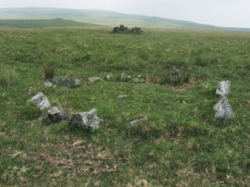
Possible ring cairn on Wigford Down damaged by stone robbing; probably for nearby road-building. Consists of a large oval depression, surrounded by a stony ring with some slabs in upright positions. Wigford Down 2 in Barrow Report 62.
Thought originally to be a damaged ring cairn, the feature consists of a large oval depression, surrounded by a stony ring with some slabs in upright positions. Feature is thought to potentially be a 'sacred' pool designed in Prehistoric times.
Nearby sites: SX 54647 65072
Distance: 1.73km
Ringmoor Down Cairn Circle
OS Map: SX 56157 65947
HER: MDV4029
Megalithic Portal: 22947
Alternate name: Ringmoor Down 3 Cairn Circle
ShortName: CC Ringmoor 3
Butler map: 49.21.3
DPD page: 36
Grinsell: SHE 18
Turner: G29
Barrow Report: 63
Notes: Located about 230m NW of the cairn circle that terminates the Ringmoor Down stone row. "An 11ft 2ins diameter cairn circle composed of fourteen stones of which four have fallen over. Stones of quartz-schorl, not granite." "This feature has the semblance of having been recently created. The stones are mostly loose and irregularly spaced. As a monument type it appears to be unique on Dartmoor. It should not be considered of great antiquity." For a photo, see: Stone-Circles.org.uk: Ringmoor Cairn. Lethbridge kerb circle p.34-36. Diagram 34 site 4.
Nearby sites: SX 56157 65947
Distance: 1.77km
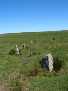
Ringmoor Down Stone Row
Prehistoric Dartmoor Walks: Dartmoor Site: Ringmoor Stone Row & Cairn Circle
OS Map: SX 56330 65808
HER: MDV3986
Megalithic Portal: 2102
The Stone Rows of GB: Ringmoor Down
PMD: Ringmoor Down Stone Row
ShortName: SR Ringmoor
Butler map: 49.20
DPD page: 34
Notes: "A stone row, 1740 feet long, mainly single but double in parts. At its southern end is a cairn circle with a diameter of 40ft. 6ins. In 1909 the circle was restored and five of the present stones were introduced from elsewhere. Prior to restoration one stone was standing, four had fallen and the presumed sites of six other stones were represented by pits. A 4ft long fallen stone terminated the stone row at its northern end". Lethbridge p.34-36, diagram p.34 site 3. See also: Sea Views at Ringmoor Down`
Nearby sites: SX 56330 65808
Distance: 1.99km
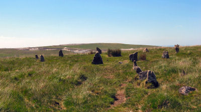
Ringmoor Down Encircled Cairn
OS Map: SX 56334 65807
HER: MDV3987
Megalithic Portal: 1233
PMD: Ringmoor Down Stone Row
Alternate name: Ringmoor Down stone row Encircled Cairn
ShortName: EC Ringmoor S
Butler map: 49.20
DPD page: 35
Grinsell: SHE 19
Turner: F5
Notes: "The cairn circle measures approximately 12.6m. in diameter and has eleven stones averaging 0.7m. high. The disturbed central cairn is 9.5m. in diameter and 0.4m. in height." "1909 the circle was restored and five of the present stones were introduced from elsewhere. Prior to restoration one stone was standing, four had fallen and the presumed sites of six other stones were represented by pits." Lethbridge Brisworthy cairn circle p.34-35. Diagram p. 34 site 2.
Nearby sites: SX 56334 65807
Distance: 1.99km
Ringmoor Down Stone Ring Cairn Circle
OS Map: SX 56113 65922
HER: MDV19760
Megalithic Portal: 34142
Alternate name: Ringmoor Down 4 Stone Ring Cairn Circle
ShortName: CC Ringmoor 4
Butler map: 49.21.4
Turner: A2
Notes: HER: A low, disturbed circular earthwork on the upper ridge of Ringmoor Down is a probable ring cairn. The bank is low and spread being up to 4.6m wide by 0.1m high and forms a slightly irregular circle with an internal diameter of between 28 and 30m and overall diameter of 37m. Two lines of tin prospecting pits which traverse the monument, of probable medieval or post medieval date, have caused some damage on the southern arc of the bank and its interior.
Nearby sites: SX 56113 65922
Distance: 1.74km
Wigford Down Stone Ring Cairn Circle
OS Map: SX 5469 6505
HER: MDV48904
Megalithic Portal: 3536
Alternate name: Wigford Down 9 Stone Ring Cairn Circle
ShortName: RC:Wigford 9
Butler map: 48.1.9
Grinsell: MEA 3a
Turner: A31
Notes: "Ring cairn, wigford down. Internal diam 2.7m, with bank 1m wide and 0.2m high. Smallest ring cairn (diam) on dartmoor. Turner suggests a link between the construction of this, small, ring cairn, with the larger cairn sx56nw/11 to its nw."
Nearby sites: SX 5469 6505
Distance: 1.75km
Wigford Down Cairn Circle
OS Map: SX 54172 65243
HER: MDV2300
Alternate name: Wigford Down 12 Cairn Circle
ShortName: CN Wigford12
Grinsell: MEA 2a
Notes: Retaining circle on nw slope of wigford down a little way to north of a green track which leads from the salient point of the enclosure wall between Urgles and Higher Bellever to the high road near durance.183m away lies a pound with two hut circles associated. Southern circumference of circle has been robbed and stones of cairn removed. The stones of the circle are small, only one exceeding 1.22m
Nearby sites: SX 54172 65243
Distance: 1.62km
Wigford Down (S) Stone Ring Cairn Circle
OS Map: SX 54702 64962
HER: MDV2367
Megalithic Portal: 3536
PMD: Wigford Down Summit
Alternate name: Wigford Down 5 Stone Ring Cairn Circle
ShortName: RC Wigford 5
Butler map: 48.1.5
Grinsell: MEA 7b
Turner: B9
Barrow Report: 62
Notes: "One of two cairn circles, both in a raised platform. Ring of large stones. Cist cover in centre. Diam 7.62m.". This site could also be a hut circle - it is unclear whether the large slab is a cist cover or not. See Butler Vol 3 p.97 fig. 48.1.2 Wigford Down 4 in Barrow Report 62. NMR A.
Nearby sites: SX 54702 64962
Distance: 1.84km
Wigford Down 2 Cairn
OS Map: SX 54675 65110
HER: MDV2312
ShortName: CN Wigford 2
Butler map: 48.1.2
Grinsell: MEA 2
Barrow Report: 62
Notes: The remains of a disturbed prehistoric cairn. It was re-used as an observation post during World War Two. Wigford Down 1 in Barrow Report 62.
Nearby sites: SX 54675 65110
Distance: 1.69km
Wigford Down 4 Embanked Cairn Circle
OS Map: SX 54694 64972
HER: MDV2368
Megalithic Portal: 3536
ShortName: CC Wigford 4
Butler map: 48.1.4
Grinsell: MEA 7a
Turner: A39
Barrow Report: 12 62
Notes: Listed as Wigford Down B on Tom Greeves list of potential 'Sacred' Pools.
NMR B. "Stone ring, diam 10.5m, with bank 2.5m wide and 0.5m high.3m wide entrance on s side" See Butler Vol 3 p.97 fig. 48.1.2. Wigford Down 3 in Barrow Report 62.
This ring cairn survives as a circular bank measuring up to 3.5 metres wide and 0.75 metres high which surrounds a flat interior up to 17.5 metres in diameter. There is evidence for partial early excavation or robbing on the south west side. Noted in 2019 as a possible 'sacred' pool.
Nearby sites: SX 54694 64972
Distance: 1.83km
Wigford Down C Ancient Pool
OS Map: SX 54733 64981
HER: MDV127231
ShortName: PO:WigfordC
Notes: "A pool measuring 22 by 17.5m. One of over 40 such 'sacred' pools identified on Dartmoor that are thought to have potentially been designed during the prehistoric period. Lies near two cairns"
Nearby sites: SX 54733 64981
Distance: 1.82km