
Hingston Hill (Down Tor) Stone Row
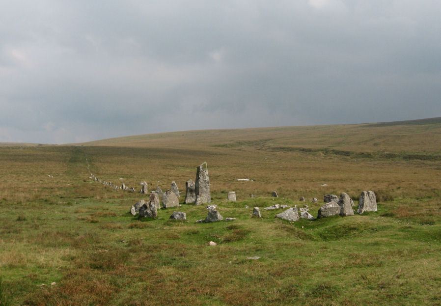
Photo taken on 06-09-2014

Photo taken 26/10/24
Database entries
PDW coverage: Dartmoor Site: Down Tor Stone Row and Cairn Circle
OS Map: SX 58697 69267
OS Source: SRGB
HER: MDV3502
Megalithic Portal: 1901
The Stone Rows of GB: Hingston Hill
PMD: Down Tor Stone Row
Alternate name: Hingston Hill
Short Name: SR Down Tor
Butler map: 47.12
DPD page: 28
Exist: Yes
Record: Unique
Record Source: PDW
Hut Class: No
Barrow Report: 66
Dimensions (m): 351
Lidar: SX 58697 69267
Guide Map: 43
Nearest Bus Stop: Princetown Dartmoor Visitor Centre (5.6 km) [Route: 98,171,172]
Nearby sites: SX 58697 69267
Notes
"A stone alignment and cairn, situated on a saddle 620 metres east of Down Tor. The alignment is orientated east-north-east to west-south-west, running for 316 metres and containing at least 174 stones, with the tallest at either end. The westernmost stone stands 2.8 metre high, the easternmost stone stands 1.6 metres high, and the remainder vary between 1 metre and 0.2 metres in height. The westernmost stone, and an unknown number of others, were re-erected by Baring-Gould and Burnard in 1894. The cairn lies 4 metres west of the western end of the alignment. The cairn mound measures 8 metres in diameter and 0.7 metres high. It is surrounded by a kerb made up of 24 orthostats, standing between 0.3 and 1 metre high, forming a ring with a diameter of 11.5 metres. A hollow in the centre of the mound suggests partial early excavation or robbing. Two tin prospecting pits lie immediately against the edge of the kerb. The alignment is in direct line with another cairn to the north-east (438589)". Lethbridge pp.27-29, diagram p.27. See also: Sea Views at Hingston HillReferences
These are selected references with an emphasis on out of copyright sources linked as PDFs. For more detailed references try any linked HER or PMD record above.
- Baring-Gould, Sabine, A Book of Dartmoor, (2002)
- Bate, C Spence, On the Prehistoric Antiquities of Dartmoor, T.D.A. Vol.4 pp.491-516 (1871)
- Brailsford, J. W, Bronze Age Stone Monuments of Dartmoor, Antiquity Volume 12, Number 48 pp.444-63 (1938)
- Brent, Francis, Prehistoric Remains on Dartmoor, Journal of the British Archaeological Association Vol.39 pp.217-222 (1883)
- Breton, Henry Hugh, The Forest of Dartmoor, (1990)
- Burnard, Robert, Dartmoor Pictorial Records, (1986)
- Butler, Jeremy, Dartmoor Atlas of Antiquities, vol.3: The South-West, (1994)
- Emmett, D.D., Stone rows: the traditional view reconsidered, D.A.S.P. No.37 pp.94-114 (1979)
- Lukis, W.C, Report on the Monuments of Dartmoor, Proceeding of the Society of Antiquaries Vol.8 (1881)
- Rowe, Samuel, A Perambulation of Dartmoor (3rd Edition), (1896)
- Worth, R. Hansford, The Dartmoor Menhirs, T.D.A. Vol.72 pp.191-200 (1940)
- Worth, R. Hansford, The Stone Rows of Dartmoor Part 1, T.D.A. Vol.78 pp.285-316 (1946)
- Worth, R. Hansford, Barrow Report 66, T.D.A. Vol.79 pp.31-34 (1947)
- Worth, R.N., The Stone Rows of Dartmoor - Part 1, T.D.A. Vol.24 pp.387-417 (1892)
- Worth, R.N., Barrow Report 14, T.D.A. Vol.24 (1892)