
Hurston Ridge Stone Row
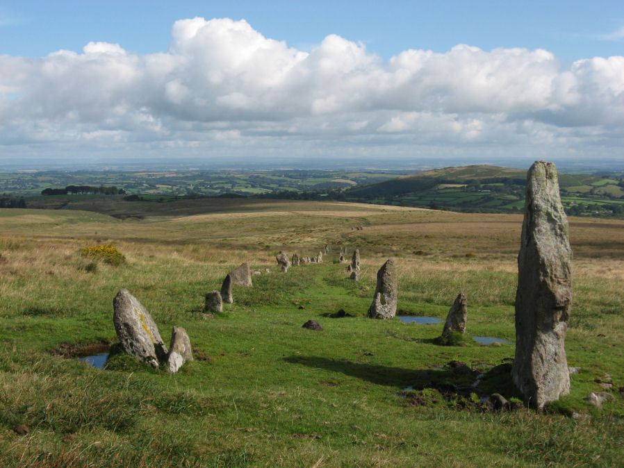
Photo taken on 26-08-2012
Database entries
PDW coverage: Dartmoor Site: Hurston Ridge Double Stone Row
OS Map: SX 67260 82437
OS Source: SRGB
HER: MDV6541
Megalithic Portal: 8345
The Stone Rows of GB: Hurston Ridge
PMD: Hurston Ridge Stone Row
Alternate name: Hurston Ridge
Short Name: SR Hurston
Butler map: 25.9
Butler Vol 5: p.228 & Fig.161
DPD page: 136
Exist: Yes
Record: Unique
Record Source: PDW
Hut Class: No
Dimensions (m): 143
Lidar: SX 67260 82437
Guide Map: 21
Nearest Bus Stop: Warren House Inn (2.0 km) [Route: 171]
Nearby sites: SX 67260 82437
Notes
.Worth: Watern Hill. "A stone alignment which includes two parallel lines of upright stones leading downslope for 143 metres from a round cairn. The lower end of the alignment is denoted by a blocking stone. Midway along the alignment a length of later enclosure walling crosses the row. The cairn at the upper end of the alignment measures 5.9 metres in diameter and stands up to a height of 0.6 metres. A large slab denoting the north eastern edge of the cairn may represent a second blocking stone of the associated alignment." A number of the stones were restored to their original sockets in 1894. A broken hand axe was discovered in the pit in which one of the stones had stood near to the menhir next to the cairn. First observed by Mr. George French of Postbridge.References
These are selected references with an emphasis on out of copyright sources linked as PDFs. For more detailed references try any linked HER or PMD record above.
- Brailsford, J. W, Bronze Age Stone Monuments of Dartmoor, Antiquity Volume 12, Number 48 pp.444-63 (1938)
- Breton, Henry Hugh, The Heart of Dartmoor, (1926)
- Burnard, Robert, Scientific Memoranda Report 27: Restoration of Hurston Ridge Stone row and Laughter Tor Menhir, T.D.A. Vol.46 p.70-72 (1914)
- Butler, Jeremy, Dartmoor Atlas of Antiquities, vol.2: The North, (1991)
- Butler, Jeremy, Dartmoor Atlas of Antiquities, vol.5: The Second Millennium B.C., (1997)
- Emmett, D.D., Stone rows: the traditional view reconsidered, D.A.S.P. No.37 pp.94-114 (1979)
- Fleming, Andrew, The Prehistoric Landscape of Dartmoor Part 2: North and East Dartmoor , Proceedings of the Prehistoric Society , Volume 49 , Issue 1 , pp. 195 - 241 (1983)
- Newman, Phil, Headland Warren and the Birchtor and Vitifer Mines: An Archaeological Survey, English Heritage (2002)
- Worth, R. Hansford, The Stone Rows of Dartmoor Part 1, T.D.A. Vol.78 pp.285-316 (1946)
- Worth, R. Hansford, The Stone Rows of Dartmoor Part 2, T.D.A. Vol.79 pp.175-186 (1947)
- Worth, R.N., The Stone Rows of Dartmoor - Part 3, T.D.A. Vol.26 pp.296-307 (1894)