
Holne Ridge N.1 Reported Cairn
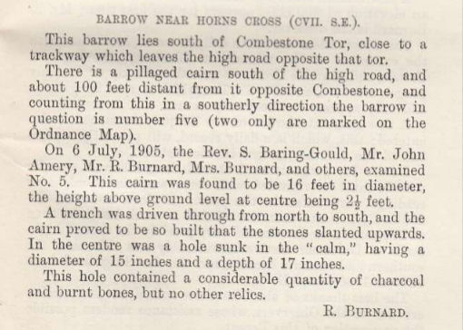
Account from Burnard in Barrow Report 24
Database entries
OS Map: SX 6700 7175
OS Source: Butler
Butler OS: SX67007175
HER: MDV6445
Alternate name: Holne Ridge N.1
Short Name: CN?HolneRidg 1
Butler map: 60.26.1
Grinsell: HOLNE 6a
Exist: Maybe
Record: Unique
Record Source: Butler
Hut Class: No
Cairn Class: Maybe
Barrow Report: 24
Dimensions (m): 16? X 0.3
Lidar: SX 6700 7175
Guide Map: 40
Nearest Bus Stop: Dartmeet Badgers Holt (2.0 km) [Route: 172]
Nearby sites: SX 6700 7175
Notes
Possibly destroyed. Butler: Holne Ridge N. '1' at SX67007175 was a fine cairn until 1878 when Crossing witnessed it 'gradually disappear under the hammer of the stone breaker'. Its remains are a disorganised rim of stone and earth which lie close to one of the parallel reaves about 25 metres from the road opposite the car parkSee also SiteID=4033 which also references the Butler entry but the NGR is around 300 metres away?
References
These are selected references with an emphasis on out of copyright sources linked as PDFs. For more detailed references try any linked HER or PMD record above.
- Butler, Jeremy, Dartmoor Atlas of Antiquities, vol.4: The South-East, (1993)
- Crossing, William, Guide to Dartmoor, (2001)
- Grinsell, L.V., Dartmoor Barrows, Devon Archaeological Society Proceedings No.36 (1978)
- Worth, R. Hansford, Barrow Report 24, T.D.A. Vol.37 pp.87-95 (1905)