
Deadman's Bottom, North Cist
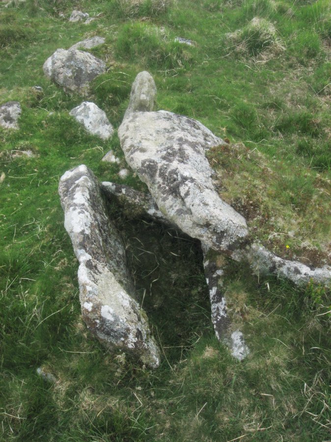
Photo taken on 04-06-2016
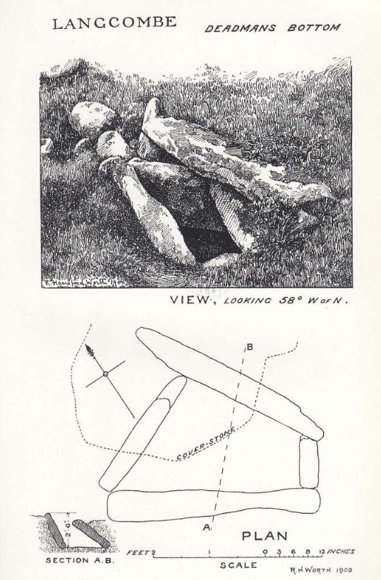
Plan by RHW. Barrow Report 19. TDA Vol.32 1900
Database entries
PDW coverage: Dartmoor Site: Guide to the Langcombe Brook & Deadman's Bottom Cists
OS Map: SX 60782 66900
OS Source: Garmin
Butler OS: SX60776689
HER: MDV5120
Megalithic Portal: 3194
PMD: Deadman's Bottom N 1
Alternate name: Langcombe Brook 2
Short Name: CT Deadmans N
Butler map: 50.3.2
Dixon Cist #: 8
Grinsell: SHAUGH PRIOR 7
DPD page: 44
Exist: Yes
Record: Unique
Record Source: Butler
Hut Class: No
Cist Class: Yes
Cairn Class: Yes
Barrow Report: 12 19
Dimensions (m): c.1.0 x 0.4 C
Lidar: SX 60782 66900
Guide Map: 50
Nearest Bus Stop: Lee Moor Clearview (7.9 km) [Route: 59]
Nearby sites: SX 60782 66900
Notes
"The remains of a cist lie on the northern slopes of Deadmans Bottom. The feature consists of a stone lined box, c.1m long and c. 0.4m wide, with a coverstone which has now slid to the north. The cist has collapsed in on itself. There is a turf covered stone spread to the south but little real evidence of an associated cairn." Lethbridge p.44 Langcombe Cist C - diagram p.43 Butler Langcombe Brook 2 (Cist 2) - Vol. 3. Map 50.3 (pp.148-54 general plan of Langcombe Brook cairns p.151, diagram of Deadmans Bottom cists p.149).References
These are selected references with an emphasis on out of copyright sources linked as PDFs. For more detailed references try any linked HER or PMD record above.
- Butler, Jeremy, Dartmoor Atlas of Antiquities, vol.3: The South-West, (1994)
- Grinsell, L.V., Dartmoor Barrows, Devon Archaeological Society Proceedings No.36 (1978)
- Lethbridge, William D., Discover Preshistoric Dartmoor, (2015)
- Worth, R. Hansford, The Erme, Yealm and Torry part 1, T.P.I. Vol.11 part 1 pp.173-183 (1892)
- Worth, R. Hansford, Barrow Report 19, T.D.A. Vol.32 pp.46-54 (1900)
- Worth, R.N., Barrow Report 12, T.D.A. Vol.22 pp.49-52 (1890)