
Grims Grave Ring Setting Cairn and Cist
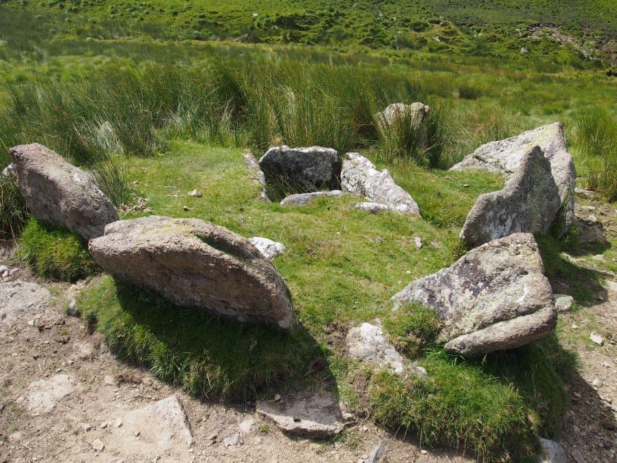
Photo taken on 17-07-2016
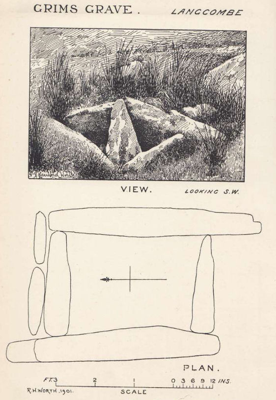
Plan by RHW. Barrow Report 20. TDA Vol.33 1901
Database entries
PDW coverage: Dartmoor Site: Guide to the Langcombe Brook & Deadman's Bottom Cists
OS Map: SX 61245 66422
OS Source: Google
Butler OS: SX61246641
HER: MDV5083
Megalithic Portal: 14930
PMD: Grim's Grave
Alternate name: Grims Grave
Short Name: CT Grims Grave
Butler map: 50.3.3
Dixon Cist #: 14
Grinsell: SHAUGH PRIOR 13
Turner: D20
DPD page: 46
Exist: Yes
Record: Unique
Record Source: Butler
Hut Class: No
Cist Class: Yes
Cairn Class: Yes
Barrow Report: 12 20 56
Dimensions (m): 5.5 x 0.6 C
Lidar: SX 61245 66422
Guide Map: 50
Nearest Bus Stop: Lee Moor Clearview (7.9 km) [Route: 59]
Nearby sites: SX 61245 66422
Notes
"A ring cairn set into the slope, c 4.5m in diameter, with a cist at its centre. The cairn consists of a stony, turf-covered mound contained by a ring of upright slabs, most leaning outwards, c 1m in height; the mound rises to c 0.4m at top of cist. The cist, box dimensions c 0.8m x 0.95m internally, is formed from edge-set slabs. One side slab is c 1.7m long, 0.9m wide and 0.2m thick. The monument survives in a very good condition though the cover-stone is missing - this is possibly the slab that now lies on the down-slope side."Lethbridge p.46 Langcombe Cist G (Grim's Grave) - diagram p.43. Butler Vol. 3. Map 50.3 Cairn 3 (pp.148-54 general plan of Langcombe Brook cairns p.151, diagram of Langcombe cists p.153, photo pp.94-96).
Grinsell [Folklore 1976]: The name Grim's Grove, or Grim's Grave, is shown near here on the surveys of Dartmoor Forest of 1240 and 1609, and was identified as this site by C. Spence Bate, an identification which has had supporters and critics. Bate 1872, 531-2; Crossing 1912/1965, 408.
References
These are selected references with an emphasis on out of copyright sources linked as PDFs. For more detailed references try any linked HER or PMD record above.
- Butler, Jeremy, Dartmoor Atlas of Antiquities, vol.3: The South-West, (1994)
- Chudleigh, J, An Exploration of Dartmoor's Antiquities, (1892)
- Crossing, William, Guide to Dartmoor, (2001)
- Falcon, T.A., Dartmoor Illustrated, (1900)
- Grinsell, L.V., Grinsell, Folklore of Prehistoric Sites in England, (1976)
- Grinsell, L.V., Dartmoor Barrows, Devon Archaeological Society Proceedings No.36 (1978)
- Lethbridge, William D., Discover Preshistoric Dartmoor, (2015)
- Page, John Lloyd Warden, An Exploration of Dartmoor and its Antiquities, with some account of its borders, (1889)
- Rowe, Samuel, A Perambulation of Dartmoor (3rd Edition), (1896)
- Turner, J.R., Ring Cairns, stone circles and related monuments on Dartmoor, D.A.S.P. No.48 pp.27-86 (1990)
- Worth, R. Hansford, The Moorland Plym, T.P.I. Vol.10 Part 3 p.294 (1890)
- Worth, R. Hansford, Barrow Report 20, T.D.A. Vol.33 pp.104- 146 (1901)
- Worth, R. Hansford, Barrow Report 21, T.D.A. Vol.34 pp.104- 146 (1902)
- Worth, R. Hansford, Barrow Report 56, T.D.A. Vol.69 pp.75-109 (1937)
- Worth, R.N., Barrow Report 12, T.D.A. Vol.22 pp.49-52 (1890)