
Doe Tor Cist

Photo taken on 24-05-2015
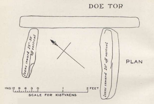
Plan by RHW. Barrow Report 24. TDA Vol.37 1905
Database entries
OS Map: SX 54383 84846
OS Source: Garmin
Butler OS: SX54388484
HER: MDV3251
Megalithic Portal: 44223
PMD: Doe Tor
Alternate name: Doe Tor E.
Short Name: CT Doe Tor
Butler map: 32.21
Butler Vol 5: p.198 & Fig.141
Dixon Cist #: 17
Grinsell: LYDFORD 12
DPD page: 10
Exist: Yes
Record: Unique
Record Source: Butler
Hut Class: No
Cist Class: Yes
Cairn Class: Yes
Barrow Report: 24
Dimensions (m): 5.0 x 0.4 C
Lidar: SX 54383 84846
Guide Map: 15
Nearest Bus Stop: Dartmoor Inn (2.7 km) [Route: 118]
Nearby sites: SX 54383 84846
Notes
Butler Doe Tor E - Vol. 2. Map 32.21 (diagram Vol. 5. p.198).References
These are selected references with an emphasis on out of copyright sources linked as PDFs. For more detailed references try any linked HER or PMD record above.
- Butler, Jeremy, Dartmoor Atlas of Antiquities, vol.2: The North, (1991)
- Butler, Jeremy, Dartmoor Atlas of Antiquities, vol.5: The Second Millennium B.C., (1997)
- Grinsell, L.V., Dartmoor Barrows, Devon Archaeological Society Proceedings No.36 (1978)
- Lethbridge, William D., Discover Preshistoric Dartmoor, (2015)
- Newman, Phil, Archaeological Sites within Willsworthy Training Area, Dartmoor National Park, Devon, Southwest Landscape Investigations (2019)
- Worth, R. Hansford, Barrow Report 21, T.D.A. Vol.34 pp.104- 146 (1902)
- Worth, R. Hansford, Barrow Report 24, T.D.A. Vol.37 pp.87-95 (1905)