
Corringdon Ball Chambered Tomb
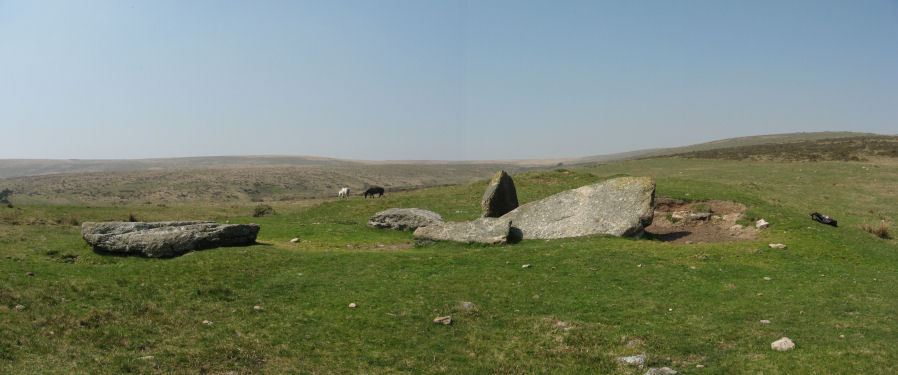
Photo taken on 18-04-2011
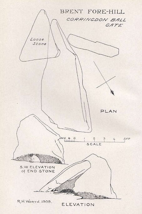
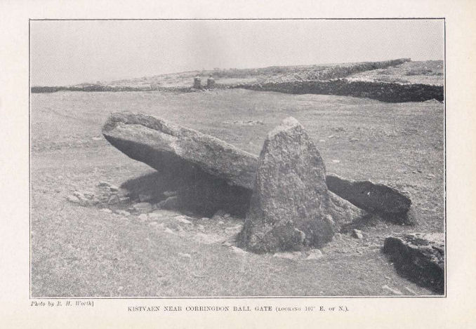
Plan by RHW. Barrow Report 28. TDA Vol.41 1909
Database entries
PDW coverage: Dartmoor Site: Corringdon Ball Chambered Tomb & Stone Rows
OS Map: SX 66956 61300
OS Source: Garmin
Butler OS: SX66946130
HER: MDV5750
Megalithic Portal: 4619
PMD: Corringdon Ball Chambered Cairn
Alternate name: Corringdon Ball chambered tomb
Short Name: NT Corringdon
Butler map: 56.10
Butler Vol 5: p.155
Dixon Cist #: 26
Grinsell: List A SOUTH BRENT 1
DPD page: 83
Exist: Yes
Record: Unique
Record Source: Butler
Hut Class: No
Cairn Class: Yes
Barrow Report: 28 56 66
Dimensions (m): 42 x 18 x 2.4
Lidar: SX 66956 61300
Guide Map: 57
Nearest Bus Stop: South Brent Pool Park (4.5 km) [Route: 38]
Nearby sites: SX 66956 61300
Notes
"An earthen long barrow with a ruined stone chamber at the south east end. Early excavation and mutilation has resulted in two distinct mounds, the larger one at the south east end separated from the smaller by a path or trackway. The smaller mound appears to mark the limit of the barrow on the northwest; beyond this it merges into the natural hill-side. There are no side ditches but these may be obscured by soil washed down from the hill. The length is 42.0 m; the maximum width is 18.0m and the maximum height of 2.4m."Photo R. H. Worth Barrow Report 56.
References
These are selected references with an emphasis on out of copyright sources linked as PDFs. For more detailed references try any linked HER or PMD record above.
- Brailsford, J. W, Bronze Age Stone Monuments of Dartmoor, Antiquity Volume 12, Number 48 pp.444-63 (1938)
- Butler, Jeremy, Dartmoor Atlas of Antiquities, vol.4: The South-East, (1993)
- Butler, Jeremy, Dartmoor Atlas of Antiquities, vol.5: The Second Millennium B.C., (1997)
- Gerrard, Sandy, English Heritage Book of Dartmoor: Landscapes Through Time, (1997)
- Grinsell, L.V., Dartmoor Barrows, Devon Archaeological Society Proceedings No.36 (1978)
- Lethbridge, William D., Discover Preshistoric Dartmoor, (2015)
- Pearce, Susan M., Archaeology of South West Britain, (1981)
- Pilkington-Rogers, C. W., The Date of the Dartmoor Antiquities, T.D.A. Vol.64 pp.379-388 (1932)
- Rowe, Samuel, A Perambulation of Dartmoor (3rd Edition), (1896)
- Todd, Malcolm, The South West to AD 1000, (1987)
- Worth, R. Hansford, Barrow Report 28, T.D.A. Vol.41 pp.93-94 (1909)
- Worth, R. Hansford, Barrow Report 56, T.D.A. Vol.69 pp.75-109 (1937)
- Worth, R. Hansford, Stray notes on the Teign Valley, T.D.A Vol.78 pp.161-170 (1946)
- Worth, R. Hansford, Barrow Report 66, T.D.A. Vol.79 pp.31-34 (1947)
- Worth, R.N., The Stone Rows of Dartmoor - Part 1, T.D.A. Vol.24 pp.387-417 (1892)