
Lakehead Hill 8 Cist
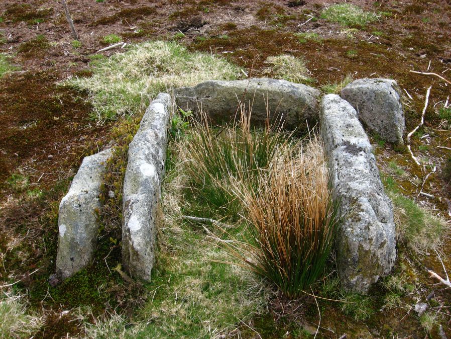
Photo taken on 15-05-2010
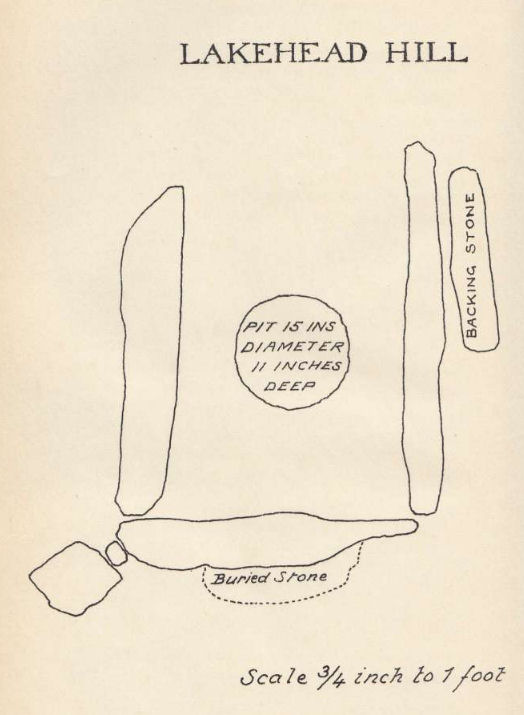
Plan by RHW. Barrow Report 33. TDA Vol.46 1914
Database entries
PDW coverage: Dartmoor Site: Lakehead Hill
OS Map: SX 64717 77178
OS Source: Google
Butler OS: SX64687718
HER: MDV5879
Megalithic Portal: 24377
PMD: Lakehead Hill SE.
Alternate name: Lakehead Hill 8
Short Name: CT Lakehead 8
Butler map: 27.19.8
Butler Vol 5: p.61 & Fig.41
Dixon Cist #: 37
Grinsell: LYDFORD 58
DPD page: 118
Exist: Yes
Record: Unique
Record Source: Butler
Hut Class: No
Cist Class: Yes
Cairn Class: Yes
Barrow Report: 33 55
Dimensions (m): 1.1 x 0.7 C
Lidar: SX 64717 77178
Guide Map: 28
Nearest Bus Stop: Postbridge Bellever (1.0 km) [Route: 98]
Nearby sites: SX 64717 77178
Notes
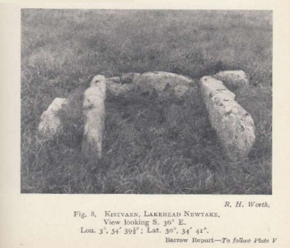
HER: Southern of two cists to east of trackway on south side of Lakehead Hill. The cist, which lies in a small cairn 4.5 metres diameter, is orientated north-north-west to south-south-east. Only three sides of the cist survive; the cap stone has also gone. It was excavated in 1914 when a pit containing charcoal was found.. Further coverage on Lakehead Hill page. Lethbridge diagram p.114 and photo bottom p.118. Butler Lakehead Hill (Cairn 8) - Vol. 2. Map 27.19.8 (diagrams pp.48-52). Discovered by Mr. George French of Postbridge.Photo R.H. Worth Barrow Report 55.
References
These are selected references with an emphasis on out of copyright sources linked as PDFs. For more detailed references try any linked HER or PMD record above.
- Breton, Henry Hugh, The Heart of Dartmoor, (1926)
- Butler, Jeremy, Dartmoor Atlas of Antiquities, vol.2: The North, (1991)
- Butler, Jeremy, Dartmoor Atlas of Antiquities, vol.5: The Second Millennium B.C., (1997)
- Grinsell, L.V., Dartmoor Barrows, Devon Archaeological Society Proceedings No.36 (1978)
- Lethbridge, William D., Discover Preshistoric Dartmoor, (2015)
- Worth, R. Hansford, Barrow Report 33, T.D.A. Vol.46 pp.93-4 (1914)
- Worth, R. Hansford, Barrow Report 55, T.D.A. Vol.68 pp.49-50 (1936)