
Brown Heath (Hook Lake) Encircled Cairn and Cist
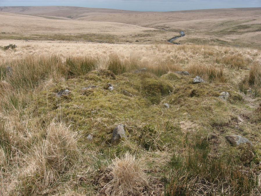
Photo taken on 19-03-2016
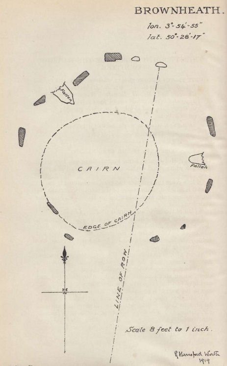
Plan by RHW. Barrow Report 38. TDA Vol.51 1919
Database entries
OS Map: SX 64114 65327
OS Source: Google
Butler OS: SX64106531
HER: MDV5137
Megalithic Portal: 52166
The Stone Rows of GB: Hook Lake
PMD: Hook Lake Stone row
Alternate name: Hook Lake stone row
Short Name: CT Hook Lake
Butler map: 55.8
Dixon Cist #: 40
Grinsell: HARFORD 3
Turner: F11
DPD page: 74
Exist: Yes
Record: Unique
Record Source: Butler
Hut Class: No
Cist Class: Yes
Cairn Class: Yes
Barrow Report: 38
Dimensions (m): 9.2 x 0.8 C
Lidar: SX 64114 65327
Guide Map: 51
Nearest Bus Stop: Cornwood Crossways (8.8 km) [Route: 59]
Nearby sites: SX 64114 65327
Notes
"A double stone row, on Brown Heath, circa 540 feet in length, direction of length N 10o E. At the north end is a stone circle, diameter 31 feet, surrounding a cairn which contains the remains of a cist." Ruined and possibly no longer visible. Butler Hook Lake stone row - Vol. 4. Map 55.8 (pp.78-9).References
These are selected references with an emphasis on out of copyright sources linked as PDFs. For more detailed references try any linked HER or PMD record above.
- Bate, C Spence, On the Prehistoric Antiquities of Dartmoor, T.D.A. Vol.4 pp.491-516 (1871)
- Butler, Jeremy, Dartmoor Atlas of Antiquities, vol.4: The South-East, (1993)
- Davidson, C. & Seabrook, R., Stone rings on south-east Dartmoor, D.A.S.P. No.31 (1973)
- Grinsell, L.V., Dartmoor Barrows, Devon Archaeological Society Proceedings No.36 (1978)
- Newman, Phil, The Upper Erme Valley Dartmoor National Park Devon An Archaeological Survey, Southwest Landscape Investigations (2018)
- Turner, J.R., Ring Cairns, stone circles and related monuments on Dartmoor, D.A.S.P. No.48 pp.27-86 (1990)
- Worth, R. Hansford, The Erme, Yealm and Torry part 1, T.P.I. Vol.11 part 1 pp.173-183 (1892)
- Worth, R. Hansford, Barrow Report 38, T.D.A. Vol.51 p.79 (1919)
- Worth, R. Hansford, The Prehistoric Pounds of Dartmoor, T.D.A. Vol.75 pp.273-302 (1943)
- Worth, R. Hansford, The Stone Rows of Dartmoor Part 1, T.D.A. Vol.78 pp.285-316 (1946)