
Lakehead Hill 4 (E or Summit) Ring Setting Cairn and Cist
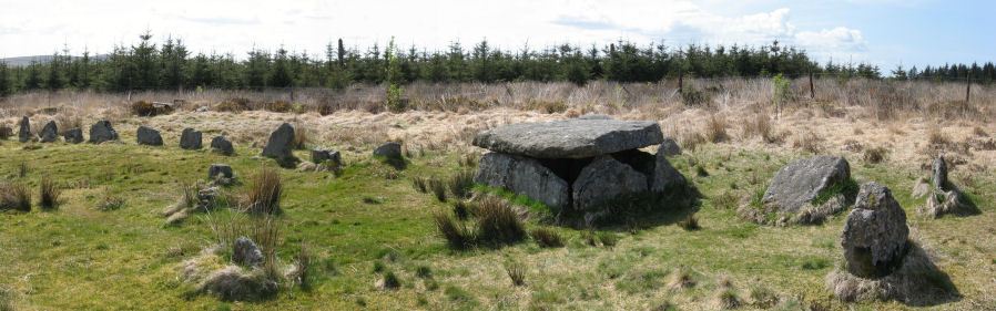
Photo taken on 15-05-2010
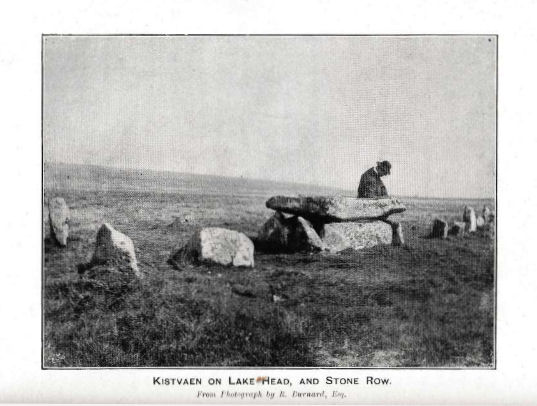
Photo R. Burnard. DEC Report 3. TDA Vol.28 1896
Database entries
PDW coverage: Dartmoor Site: Lakehead Hill
OS Map: SX 64499 77611
OS Source: Google
Butler OS: SX64497760
HER: MDV5870
Megalithic Portal: 2009
PMD: Lakehead Hill Summit
Alternate name: Lakehead Hill 4
Short Name: CT Lakehead 4
Butler map: 27.19.4
Butler Vol 5: p.59 & Fig.37
Dixon Cist #: 68
Grinsell: LYDFORD 54
Turner: D6
DPD page: 116
Exist: Yes
Record: Unique
Record Source: Butler
Hut Class: No
Cist Class: Yes
Cairn Class: Yes
Dimensions (m): 6.7? C
Lidar: SX 64499 77611
Guide Map: 28
Nearest Bus Stop: Postbridge Bellever (1.3 km) [Route: 98]
Nearby sites: SX 64499 77611
Notes
A single stone row of at least 11 stones leading westward towards the cairn and cist. HER: The cairn measures 6.7 metres in diameter and is defined by several edge set stones, which in turn surround a large restored cist formed by five substantial upright slabs supporting a capstone measuring 2.2 metre long by 1.55 metres wide and 0.3 metres thick. Further coverage on Lakehead Hill page. Lethbridge diagram p.114 and photo top p.116. Butler Lakehead Hill (Cairn 4) - Vol. 2. Map 27.19.4 (diagrams pp.48-52). Breton p.35-36References
These are selected references with an emphasis on out of copyright sources linked as PDFs. For more detailed references try any linked HER or PMD record above.
- Baring-Gould, Sabine, Third Report of the Dartmoor Exploration Committee, T.D.A. Vol.28 pp.174-199 (1896)
- Brailsford, J. W, Bronze Age Stone Monuments of Dartmoor, Antiquity Volume 12, Number 48 pp.444-63 (1938)
- Breton, Henry Hugh, The Heart of Dartmoor, (1926)
- Butler, Jeremy, Dartmoor Atlas of Antiquities, vol.2: The North, (1991)
- Butler, Jeremy, Dartmoor Atlas of Antiquities, vol.5: The Second Millennium B.C., (1997)
- Davidson, C. & Seabrook, R., Stone rings on south-east Dartmoor, D.A.S.P. No.31 (1973)
- Emmett, D.D., Stone rows: the traditional view reconsidered, D.A.S.P. No.37 pp.94-114 (1979)
- Grinsell, L.V., Dartmoor Barrows, Devon Archaeological Society Proceedings No.36 (1978)
- Lethbridge, William D., Discover Preshistoric Dartmoor, (2015)
- Turner, J.R., Ring Cairns, stone circles and related monuments on Dartmoor, D.A.S.P. No.48 pp.27-86 (1990)
- Worth, R. Hansford, The Stone Rows of Dartmoor Part 1, T.D.A. Vol.78 pp.285-316 (1946)
- Worth, R.N., The Stone Rows of Dartmoor - Part 4, T.D.A. Vol.27 pp.437-442 (1895)