
Stennen Hill No. 1 Platform Cairn Circle and Cist
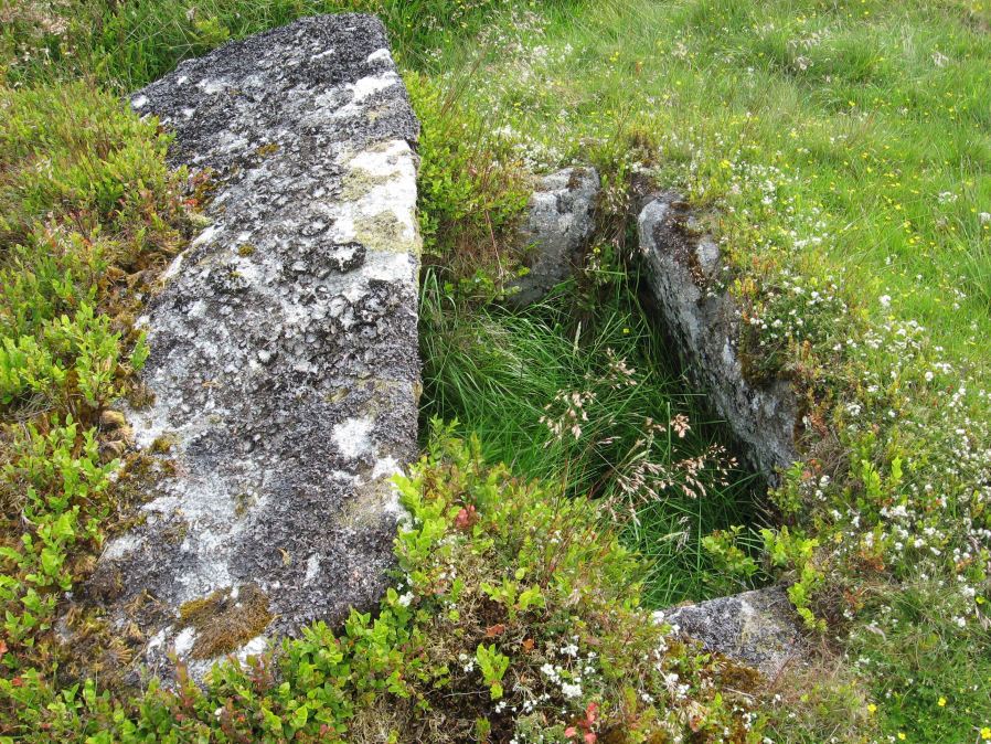
Photo taken on 27-06-2015
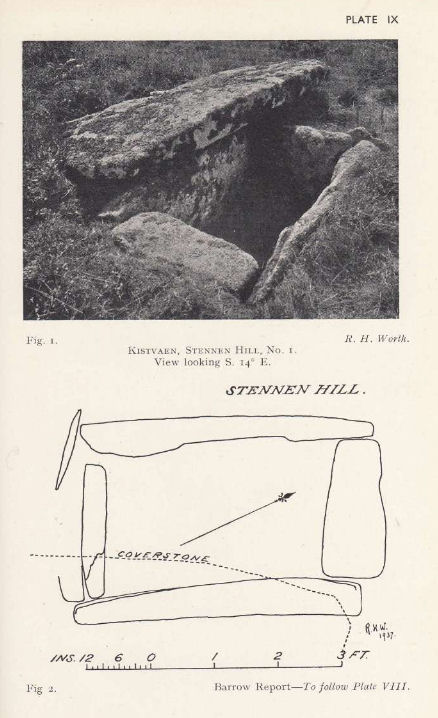
Plan by RHW. Barrow Report 57. TDA Vol.70 1938
Database entries
OS Map: SX 62573 77905
OS Source: Garmin
Butler OS: SX62597788
HER: MDV5846
Megalithic Portal: 45736
PMD: Powder Mills W.
Alternate name: Stennen Hill 1
Short Name: CT Stennen 1
Butler map: 29.11.1
Butler Vol 5: p.199 & Fig.142
Dixon Cist #: 76
Grinsell: LYDFORD 47
Turner: E13
DPD page: 111
Exist: Yes
Record: Unique
Record Source: Butler
Hut Class: No
Cist Class: Yes
Cairn Class: Yes
Barrow Report: 57
Dimensions (m): 6.5 x 0.3 C
Lidar: SX 62573 77905
Guide Map: 28
Nearest Bus Stop: Powder Mills (1.7 km) [Route: 171]
Nearby sites: SX 62573 77905
Notes
"Cist lies approximately in the centre of a subcircular cairn measuring 7 by 6.5m the longer axis and cist aligned nne to ssw. It is stony but almost turf-covered with 2 large kerbstones, including burnards `menhir' remaining in situ in the nw. The cist is flush with the cairn top, which is flattish and stands only 0.2m high on the nw but up to 0.7m high on the se, downhill side. This may be the cairn's original form; built into the slope as a flat platform with the cist visible (nmr citing pattison)". See also HER. Lethbridge photo top p.111. Butler Stennen Hill 1 - Vol. 2. Map 29.11 (diagram Vol. 5. p.199). NB. Worth & Grinsell name this Stennen Hill No. 1. Breton p.34.The photo below was taken on 09/07/2025.

References
These are selected references with an emphasis on out of copyright sources linked as PDFs. For more detailed references try any linked HER or PMD record above.
- Breton, Henry Hugh, The Heart of Dartmoor, (1926)
- Burnard, Robert, Notes on Dartmoor Kistvaens, T.D.A. Vol.22 pp.200-207 (1890)
- Butler, Jeremy, Dartmoor Atlas of Antiquities, vol.2: The North, (1991)
- Butler, Jeremy, Dartmoor Atlas of Antiquities, vol.5: The Second Millennium B.C., (1997)
- Grinsell, L.V., Dartmoor Barrows, Devon Archaeological Society Proceedings No.36 (1978)
- Lethbridge, William D., Discover Preshistoric Dartmoor, (2015)
- Turner, J.R., Ring Cairns, stone circles and related monuments on Dartmoor, D.A.S.P. No.48 pp.27-86 (1990)
- Worth, R. Hansford, Barrow Report 57, T.D.A. Vol.70 pp.59-62 (1938)