
Butterdon Hill Cist
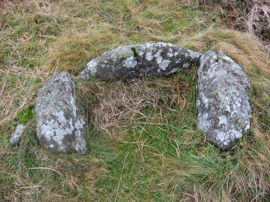
Photo taken on 12-01-2016
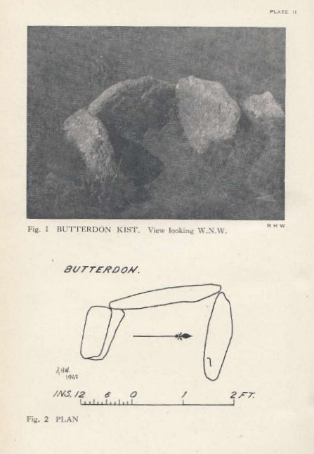
Plan by RHW. Barrow Report 61. TDA Vol.74 1942
Database entries
PDW coverage: Dartmoor Walk: The Erme East stone rows
OS Map: SX 65781 59341
OS Source: Garmin
Butler OS: SX65805933
HER: MDV2887
Megalithic Portal: 45752
PMD: Butterdon Hill
Alternate name: Butterdon Ridge N.E.
Short Name: CT Butterdon 3
Butler map: 53.8.3
Butler Vol 5: p.59 & Fig.38
Dixon Cist #: 88
Grinsell: UGBOROUGH 16
DPD page: 79
Exist: Yes
Record: Unique
Record Source: Butler
Hut Class: No
Cist Class: Yes
Cairn Class: Yes
Barrow Report: 61
Dimensions (m): 0.63 x 0.5 C
Lidar: SX 65781 59341
Guide Map: 58
Nearest Bus Stop: Ivybridge BP Garage (Stop B) (4.9 km) [Route: 38]
Nearby sites: SX 65781 59341
Notes
"The western side stone and the two end stones are still standing, but the other side stone and the cover stone are missing. The cist measures 23 inches by 15 inches"... "no sign whatever of a mound, and the cist may have been freestanding". Lethbridge p.79 East of Hangershell Rock diagram p.77. Butler Butterdon Ridge N.E. - Vol. 4. Map 53.8.3 (p.25 general plan of Butterdon rows and cairns p.24).References
These are selected references with an emphasis on out of copyright sources linked as PDFs. For more detailed references try any linked HER or PMD record above.
- Butler, Jeremy, Dartmoor Atlas of Antiquities, vol.4: The South-East, (1993)
- Butler, Jeremy, Dartmoor Atlas of Antiquities, vol.5: The Second Millennium B.C., (1997)
- Grinsell, L.V., Dartmoor Barrows, Devon Archaeological Society Proceedings No.36 (1978)
- Hankin, C. F., Archaeological checklist of Ugborough parish, D.A.S.P. No.33 (1975)
- Lethbridge, William D., Discover Preshistoric Dartmoor, (2015)
- Worth, R. Hansford, Barrow Report 61, T.D.A. Vol.74 p.67 (1942)
- Worth, R. Hansford, The Stone Rows of Dartmoor Part 1, T.D.A. Vol.78 pp.285-316 (1946)