
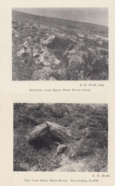
Brent Moor House Cist
Photos by RHW. Barrow Reports 65,66. TDA Vol.78,79 1946,1947
Database entries
OS Map: SX 6802 6403
OS Source: HER
HER: MDV5744
Megalithic Portal: 45754
PMD: Brent Moor House
Alternate name: Brent Moor House
Short Name: CT:Brent Moor
Dixon Cist #: 91
Grinsell: SOUTH BRENT 3
Exist: Yes
Record: Unique
Record Source: PDW
Hut Class: No
Cist Class: Maybe
Cairn Class: Maybe
Barrow Report: 65 66
Lidar: SX 6802 6403
Guide Map: 52
Nearest Bus Stop: South Brent Pool Park (6.1 km) [Route: 38]
Nearby sites: SX 6802 6403
Notes
"A cist lies on the right bank of the Avon, a short distance above Brent Moor House, about 175 feet below the small stream which flows south of Riders Rings ... The cist, which consists of two end stones and one side stone, stands in a small cairn." Doubtful. (grinsell) "supposed cairn of large stones, enclosing possible cist placed se-nw. The whole area is covered with clitter, and it is possible that the site may be natural. In summer it is under dense bracken. No measurements given." Butler Vol. 4. Map 57.9 (not actually covered in Butler but relevant map). " A Medieval or later tinner's cache situated opposite Woolholes on the west bank of the River Avon. Considered under the Monument Protection Programme by previous Monument Protection Programme Advisor who did not recommend it for scheduling."References
These are selected references with an emphasis on out of copyright sources linked as PDFs. For more detailed references try any linked HER or PMD record above.
- Grinsell, L.V., Dartmoor Barrows, Devon Archaeological Society Proceedings No.36 (1978)
- Worth, R. Hansford, Barrow Report 65, T.D.A. Vol.78 p.49 (1946)
- Worth, R. Hansford, Barrow Report 66, T.D.A. Vol.79 pp.31-34 (1947)
- Worth, R. Hansford, Barrow Report 67, T.D.A. Vol.80 p.37 (1948)