
Childes Tomb Platform Cairn Circle and Cist
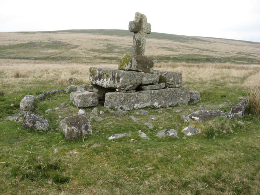
Photo taken on 18-05-2018
Database entries
OS Map: SX 62577 70299
OS Source: Garmin
Butler OS: SX62577029
HER: MDV48907
Megalithic Portal: 15211
PMD: Childe's Tomb
Alternate name: Childes Tomb
Short Name: CT ChildesTomb
Butler map: 64.4
Dixon Cist #: 94
Grinsell: LYDFORD 96
Turner: E33
DPD page: 94
Exist: Yes
Record: Unique
Record Source: Butler
Hut Class: No
Cist Class: Yes
Cairn Class: Yes
Dimensions (m): c.9.0 x 0.3 C
Lidar: SX 62577 70299
Guide Map: 39
Nearest Bus Stop: Princetown Dartmoor Visitor Centre (6.2 km) [Route: 98,171(20/07/26 to 19/09/26)]
Nearby sites: SX 62577 70299
Notes
"A much disturbed cairn, 9m in diameter and 0.3m high with a modern 'kerb' of blocks and slabs, 5.8m in diameter and 0.5m high, set upon the mound. At the centre is a well built cist 1.4m long, 0.5m wide and 0.6m deep. Over this is a two tier pedestal of eight well trimmed blocks, of three different lengths; a further half buried block lies S of the monument. Upon this is a replacement socket stone and cross, cut at Holne in 1885". Lethbridge diagram p.93, photo p.94. Butler Vol. 4. Map 64.4 (diagram p.220). Breton p.22-23References
These are selected references with an emphasis on out of copyright sources linked as PDFs. For more detailed references try any linked HER or PMD record above.
- Breton, Henry Hugh, The Heart of Dartmoor, (1926)
- Butler, Jeremy, Dartmoor Atlas of Antiquities, vol.4: The South-East, (1993)
- Carrington, Nicholas Toms, Dartmoor, a descriptive poem, with notes by W. Burt, (1826)
- Crossing, William, The ancient stone crosses of Dartmoor and its borderland, (1902)
- Crossing, William, Guide to Dartmoor, (2001)
- Grinsell, L.V., Grinsell, Folklore of Prehistoric Sites in England, (1976)
- Grinsell, L.V., Dartmoor Barrows, Devon Archaeological Society Proceedings No.36 (1978)
- Lethbridge, William D., Discover Preshistoric Dartmoor, (2015)
- Phillips, E. Masson, Ancient Stone Crosses of Devon. Part 1, T.D.A. Vol.69 pp.289-342 (1937)
- Turner, J.R., Ring Cairns, stone circles and related monuments on Dartmoor, D.A.S.P. No.48 pp.27-86 (1990)