
Cosdon Beacon Cairn Circle & Cist
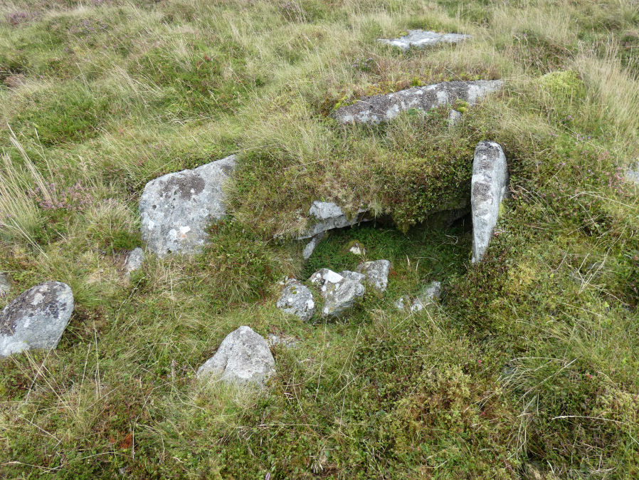
Photo taken on 12-09-2021
Database entries
PDW coverage: Dartmoor Site: Cosdon Hill Triple Stone Row
OS Map: SX 63730 91654
OS Source: Garmin
Butler OS: SX63729164
HER: MDV6925
Megalithic Portal: 10325
Alternate name: Cosdon Hill 4
Short Name: CN Cosdon 4
Butler map: 40.7.4
Butler Vol 5: p.183 & Fig.125
Dixon Cist #: 119
Grinsell: SOUTH TAWTON 1b
DPD page: 153
Exist: Yes
Record: Unique
Record Source: Butler
Hut Class: No
Cist Class: Yes
Cairn Class: Yes
Dimensions (m): 6.5 x 0.6 C
Lidar: SX 63730 91654
Guide Map: 3
Nearest Bus Stop: Ramsley (2.5 km) [Route: 670,671,6A]
Nearby sites: SX 63730 91654
Notes
"Cairn mound measures 7m in diam and stands up to 0.6m high. A central hollow, 2m by 1.8m by 1m deep, is faced on two sides with large slabs which may represent the cist described by falcon in 1905 as being 4ft long by 2ft wide. A ring of edge set stones around this cist is visible and may represent an internal kerb, which survives largely as a buried feature.". Lethbridge diagram p.152, photo bottom left p.153. Butler Cosdon Beacon 4 Vol. 2. Map 40.7.4 (diagram of Cosdon Summit cairns on p.207). Barrow Report 4 quotes Rowe (1872) and Rowe on this feature. See also Bate (1862) and Rowe's earlier account (1830). For Falcon's cist (1905) "Two stones set on edge on the eastern periphery of the mound may represent a second cist." see entry SiteID=463.NB. The grid reference SX 63730 91654 had been assigned by the author to this feature - possibly as read from Google or a subsequent visit. Unfortunately no explanation can be found so rolling back to previous Garmin reading taken on 12/09/21.
References
These are selected references with an emphasis on out of copyright sources linked as PDFs. For more detailed references try any linked HER or PMD record above.
- Butler, Jeremy, Dartmoor Atlas of Antiquities, vol.2: The North, (1991)
- Butler, Jeremy, Dartmoor Atlas of Antiquities, vol.5: The Second Millennium B.C., (1997)
- Croker, J. G., A guide to the eastern escarpment of Dartmoor, (1851)
- Falcon, T.A., Dartmoor: A Note On Graves, T.D.A. Vol.37 pp.457-461 (1905)
- Grinsell, L.V., Dartmoor Barrows, Devon Archaeological Society Proceedings No.36 (1978)
- Ormerod, George Wareing, On the Hut-Circles of the Eastern Side of Dartmoor, Journal of the British Archaeological Association Vol.20 (1864)
- Rowe, Samuel, A Perambulation of Dartmoor (3rd Edition), (1896)
- Wilkinson J. Gardner, British Remains on Dartmoor, Journal Brit. Arch. Assoc. xviii. pp.22-53, 111-133. (1862)