
Hingston Hill Chambered Cairn
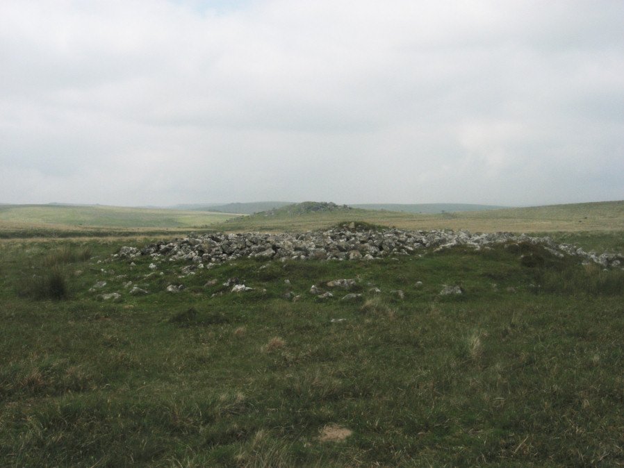
Photo taken on 26-10-2024

Photo taken 26/10/24
Database entries
PDW coverage: Dartmoor Site: Down Tor Stone Row and Cairn Circle
OS Map: SX 59201 69453
OS Source: Garmin
Butler OS: SX59206945
HER: MDV3375
Megalithic Portal: 27900
PMD: Narrator Brookhead N.
Alternate name: Narrator Brookhead 1
Short Name: CN Narrator 1
Butler map: 47.7.1
Butler Vol 5: p.158
Grinsell: WALKHAMPTON 32
Exist: Yes
Record: Unique
Record Source: Butler
Hut Class: No
Cist Class: Maybe
Cairn Class: Yes
Dimensions (m): 19.0 x 1.6
Lidar: SX 59201 69453
Guide Map: 43
Nearest Bus Stop: Princetown Dartmoor Visitor Centre (5.3 km) [Route: 98,171(20/07/26 to 19/09/26)]
Nearby sites: SX 59201 69453
Notes
The large cairn to NW of Down Tor (Hingston Hill) stone row has been claimed to contain a cist or "elements of chambering" (Burnard via PMD). A stony round cairn located on the flatish sadle of Hingston Hill. The cairn mound measures 17 metres in diameter and stands up to 1.5 metres high. A hollow in the centre of the mound measures 4 metres long, 3 metres wide and 1.2 metres deep, and is probably the result of partial robbing or early excavation. The edges of the mound are steep-sided, indicating the existence of a kerb, which now survives mainly as a buried feature. A quarry ditch surrounds the mound, visible as a 1.5 metre wide band of rushes on the northern side of the mound, the result of increased moisture in the buried ditch. This cairn is in direct line with the two terminal stones at either end of a stone alignment to the south-west.References
These are selected references with an emphasis on out of copyright sources linked as PDFs. For more detailed references try any linked HER or PMD record above.
- Brent, Francis, Prehistoric Remains on Dartmoor, Journal of the British Archaeological Association Vol.39 pp.217-222 (1883)
- Burnard, Robert, Dartmoor Pictorial Records, (1986)
- Butler, Jeremy, Dartmoor Atlas of Antiquities, vol.3: The South-West, (1994)
- Butler, Jeremy, Dartmoor Atlas of Antiquities, vol.5: The Second Millennium B.C., (1997)
- Greeves, T, Cramber Tor Training Area Monument Condition Survey, (2012)
- Grinsell, L.V., Dartmoor Barrows, Devon Archaeological Society Proceedings No.36 (1978)
- Lukis, W.C, Report on the Monuments of Dartmoor, Proceeding of the Society of Antiquaries Vol.8 (1881)
- Worth, R. Hansford, The Dartmoor Menhirs, T.D.A. Vol.72 pp.191-200 (1940)
- Worth, R. Hansford, The Prehistoric Pounds of Dartmoor, T.D.A. Vol.75 pp.273-302 (1943)
- Worth, R.N., The Stone Rows of Dartmoor - Part 1, T.D.A. Vol.24 pp.387-417 (1892)
- Worth, R.N., Barrow Report 14, T.D.A. Vol.24 (1892)