
Prestonbury Castle Fort
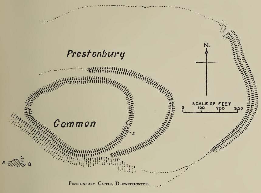
Plan: J.C. Wall in Ancient Earthworks (1906)
Database entries
PDW coverage: Dartmoor Resource: Table of Devon Iron Age Forts
OS Map: SX 74683 90025
OS Source: Google
HER: MDV8439
Megalithic Portal: 29170
Alternate name: Prestonbury Castle
Short Name: FT:Prestonbury
Exist: Yes
Record: Unique
Record Source: PDW
Hut Class: No
Lidar: SX 74683 90025
Guide Map: 14
Nearest Bus Stop: Drewsteignton Square (1.8 km) [Route: 173]
Nearby sites: SX 74683 90025
Notes
"Iron Age hillfort, inner works complete, but possibly outer works never finished. Prestonbury Castle is situated three miles north-west of Moretonhampstead high above the north bank of the R Teign. The bank of the inner enclosure measures 418 feet by 410 feet and is 7 1/2 feet high with entrances to the east and west. The middle enclosure bank has a simple entrance on its east side. The outer bank, only partially extant, is strengthened by a rock-cut ditch 20 feet broad. This bank divides into two at the crest of the southern slope. The bank has an inturned entrance facing northeas"References
These are selected references with an emphasis on out of copyright sources linked as PDFs. For more detailed references try any linked HER or PMD record above.
- Fox, Aileen, Hill-Slope Forts and Related Earthworks in South-West England and South Wales, Archaeological Journal Vol 109 (1952)
- Fox, Aileen, Prehistoric hillforts in Devon, (1996)
- Gerrard, Sandy, English Heritage Book of Dartmoor: Landscapes Through Time, (1997)
- Greeves, T, The Archaeology of Dartmoor from the Air, (1985)
- Newman, Phil, The Field Archaeology of Dartmoor, (2011)
- Pilkington-Rogers, C. W., The Date of the Dartmoor Antiquities, T.D.A. Vol.64 pp.379-388 (1932)
- Rowe, Samuel, A Perambulation of Dartmoor (3rd Edition), (1896)
- Wall, J. Charles, Ancient Earthworks, The Victoria History of the County of Devon: v. 1 pp.573-630 (1906)
- Wilkinson J. Gardner, British Remains on Dartmoor, Journal Brit. Arch. Assoc. xviii. pp.22-53, 111-133. (1862)