
East Hill Fort

Photo taken on 24-03-2024
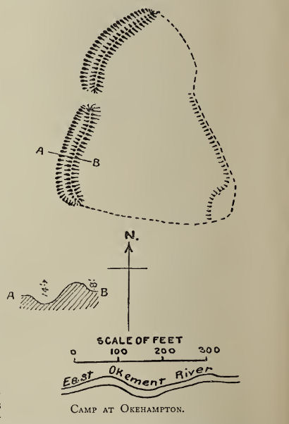
Plan: J.C. Wall in Ancient Earthworks (1906)
Database entries
PDW coverage: Dartmoor Resource: Table of Devon Iron Age Forts
OS Map: SX 60397 94162
OS Source: PDW
HER: MDV6880
Megalithic Portal: 47073
Alternate name: East Hill
Short Name: FT East Hill
Exist: Yes
Record: Unique
Record Source: PDW
Hut Class: No
Lidar: SX 60397 94162
Guide Map: 2
Nearest Bus Stop: Okehampton Railway Station (1.6 km) [Route: 118,306,6A]
Nearby sites: SX 60397 94162
Notes
"A promontory fort of likely Iron Age date containing a further, probably earlier, enclosure. It occupies an elevated position at the tip of the spur between the East Okement River and the Moor Brook. The southern and eastern sides of the site are formed by precipitous slopes that fall into wooded gorges while the west and northwest are delimited by a well-defined rampart and ditch pierced by a single entrance. The highest point within the fort, the SE quadrant, is occupied by the earlier enclosure which does not possess an entrance. Traces of ridge and furrow are visible in the southern part of the interior."References
These are selected references with an emphasis on out of copyright sources linked as PDFs. For more detailed references try any linked HER or PMD record above.
- Baring-Gould, Sabine, A Book of Dartmoor, (2002)
- Brailsford, J. W, Excavations at the promontory fort near Okehampton Station, D.A.S.P. No.3 pt 2 pp.86-91 (1938)
- Crossing, William, Guide to Dartmoor, (2001)
- Fox, Aileen, Prehistoric hillforts in Devon, (1996)
- Gerrard, Sandy, English Heritage Book of Dartmoor: Landscapes Through Time, (1997)
- Page, William, The Victoria History of the County of Devon: v. 1, (1906)
- Pilkington-Rogers, C. W., The Date of the Dartmoor Antiquities, T.D.A. Vol.64 pp.379-388 (1932)
- Wall, J. Charles, Ancient Earthworks, The Victoria History of the County of Devon: v. 1 pp.573-630 (1906)
- Worth, R.N., Okehampton Beginnings, T.D.A. Vol.27 pp.93-112 (1895)