ROUTE: Long Hilly walk - potentially boggy terrain. Start Okehampton. Follow East Okement to Belstone Common. Over Belstone Tor and on to Little Hound Tor. Round Cosdon Hill to South Zeal and Sticklepath. Distance 16km.
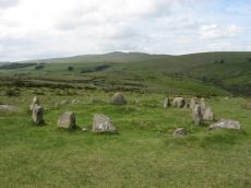
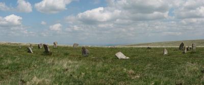
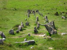
SITES OF INTEREST: Belstone Nine Maidens Cairn Circle. Little Hound Tor Stone Circle. Cosdon Hill Triple Stone Row.
PUBLIC TRANSPORT: Dartmoor Line train Exeter to Okehampton (Summer Sundays only). Gunnislake/Plymouth to Okehampton First 187 (Summer Sundays only). Western Greyhound 510 & 599 Exeter to Okehampton (daily).
Belstone and Cosdon Hill
From Okehampton train station head up to the road which leads up on to the open moor of Okehampton Camp. Head a few yards in the opposite direction back towards Okehampton to find a bridle path on the right heading east along the East Okement River. Follow this pleasant wood and river side walk for 1.5km to go under the A30 and south for another 1.5 km along the Tarka Trail. Use the narrow footbridge to exit the woods and come out on open moor. Follow the route of the Tarka Trail path which heads NNE to the Old rectory farm and then south for about 1km. The wide tracks make navigation easy - the Nine Stones Cairn Circle is just uphill from the two of these tracks just as they run parallel prior to joining up. From the Nine Stones head up to the top of Belstone Tor. This is a steep and hilly climb but the views are fantastic and it is worth exploring the outcrops on the top of Belstone Tor. Find a suitable route downhill heading due east until you reach the main track at the bottom. A short distance along this track you will see the Irishman's Wall ascending over Belstone Tor. If the walk is being attempted in late summer then you may find that there is a bracken free "corridor" close to the right hand side of Irishman's wall as it descends the hill, although the terrain maybe rocky so mind your ankles!
The objective is to cross the River Taw and ascend Cosdon Hill. The route that follows can get very boggy under foot and may require some circuitous navigation. Head south along the main track and turn left at the junction heading east across the ford. This ford was passable at the time this walk was done in June 2010 but it might be more difficult at different times of year. It may be necessary to wade across - obviously you will need to assess how safe this is to do after heavy rains. If it is not possible to cross the Taw, or the terrain is generally too boggy, then it may be worth leaving the rest of this route to another day and/or breaking the walk into two by starting from Sticklepath (accessible by bus) and heading over Cosdon from there. Alternatively you could head north into Belstone and rejoin the Tarka Trail and head on to the Western slope of Cosdon Hill starting from the north joining up with main path marked on the OS map.
Once across the ford, head east on to the western slopes of Cosdon Hill. Follow the track south and find a convenient point to cross the boggy terrain. About 0.5km from the first ford is a second ford, the other side of which is Taw Marsh. Instead of crossing the second ford follow the River Taw up hill to join the path marked on the OS map on White Hill. If a drier route across can be found earlier, for example at the first ford, then take it!
On higher drier ground there are settlements (SX626906) on White hill. Keeping to the path, as marked on the map, if not obvious in the terrain, head south east up hill and then south to Little Hound Tor. The Little Hound Tor Stone Circle is just south of the tor. After taking a look at the White Moor Stone head north east keeping to the route of the path as marked on the OS map. The path is not obvious but it essentially hugs the contour. Downhill to the east is the rather boggy terrain of Raybarrow Pool. For around 2km avoid going uphill and especially in the early stages avoid downhill! Due east of the summit of Cosdon Hill is the rather spectacular Cosdon Hill triple stone row.
From the stone row follow the route of the OS marked path taking the northerly fork to head back towards South Zeal. There is a group of walled off fields - go round these on the right (east) hand side sticking to the path as marked on the map. It may look like you can go the other way round, on the western side of the walled fields, but the terrain can become very boggy.
Stick to the now clearly defined path. The path will meet with a minor road - take a right downhill. Around here can be seen the peculiar pixie house carved into the side of a tree. From South Zeal walk along the road into Sticklepath for the bus back to Okehampton for the train or bus home.
Page last updated 22/8/11