ROUTE: Easy medium length walk. Start Ivybridge Train Station. Davey Cross. Butterdon Hill, Piles Hill, Glasscombe Corner, Corringdon Ball, Butterbrook reservoir. Finish Ivybridge Train Station. Distance 15km.
SITES OF INTEREST: Rows, Cairns & Chambered Tomb; Cuckoo Ball, Butterdon Hill, Piles Hill, Glasscombe Corner & Corringdon Ball, Butter Brook Settlement
PUBLIC TRANSPORT: Train to and from Ivybridge.
The Neolithic tombs of Cuckoo Ball & Corringdon Ball
This is an easy medium length walk incorporating three Neolithic sites. This area is dense with stone rows and cairns and the route can be adapted to incorporate numerous sites. For an alternative route around this area see Ivybridge 1: The Erme East stone rows
Ivybridge Train Station to Cuckoo Ball
Start at Ivybridge train station and head south along the approach road to the station on to the main road to Ivybridge. Head west and take the second left turn at Davey Cross. Davids Lane passes over the railway and climbs directly north for a further 0.5km terminating at a gate. On the way you will pass a turning to the right for the Redlake Industrial Estate and further on a private road for Moorhedge Farm. Go through the gate and continue to ascend to a second gate on the right as the lane bends sharply to the left. Pass through this gate on to the open moor and head eastwards. A very short distance on to the moor is a well or trough, the ground in front of the trough can get a bit boggy, to avoid this climb uphill around it. Heading east join the disused china clay works rail trackway, or alternatively head north uphill to join it earlier. The Cantrell stone row is easy to miss as it is a rather diminutive and unimpressive and overgrown row of nine small stones that rise uphill from the trackway at a very narrow angle.
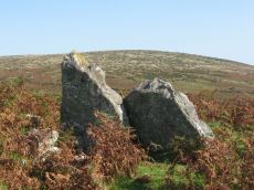
Continue to head eastwards along the trackway. The trackway curves round giving way to an ill-defined path climbing northwards. Cuckoo Ball chambered tomb is in the enclosure ahead and should become visible as you progress towards it. Head to the north of the enclosure wall where there is an entrance a few yards beyond the corner of the wall. There is a damaged part of the enclosure wall that is easy to go over but there is no need to risk damaging the wall further as there is an entrance just a few yards further around the corner.
Note: Double click or use the controls on the map to zoom in for more detail.
Cuckoo Ball to Corringdon Ball
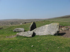
From Cuckoo Ball head almost due north to find the Butterdon Hill long barrow, but first go a short distance east. Exit the enclosure and follow the enclosure wall eastwards (wall on your right) until you approach another sharp bend in the wall. From here continue towards the Lud Brook and just before the stream is a path heading NNW. After about 250m or about 5 minutes walking the Butterdon Hill long barrow should be on the right of the path. The mound is 25 metres long, orientated north-south, is 16m wide and 0.9m high at the north end and 10m wide and 0.7m high at the south end. A number of slabs protrude from the mound mostly along the eastern side and a prominent slab jutting out at the northern end. The mound has a number of bushes on it. It is quite easy to miss this site as although large it is not of a great height and tends to blend in with the general overgrowth in the area.
The simplest route is to head west to Butterdon Hill or north-west towards the substantial cairn a little way north of Butterdon Hill. Follow the Butterdon Hill stone row until it rejoins the rail trackway. Alternatively, from the Butterdon Hill long cairn you could continue due north over rough terrain and you should meet a very minor path that heads due north towards Spurrell's Cross - this path passes close to the massive slabs Beacon A & B which are speculated to have been potential massive standing stones.
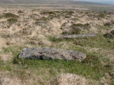
Once back on the trackway stick to it for about 0.5km, you will see Spurrell's Cross a way to the right as the trackway curves sharply to head north. Just under another 0.5km the recumbent stones of the Glasscombe Ball N stone row can be seen a few yards to the right of the trackway. These can be easy to miss but if you pass them it is no trouble as a further 0.5km along the trackway you reach the top of Piles Hill with the prominent large cairns and the easier to find massive fallen stones of the Piles Hill row. Follow the row of your choice down hill to the east and after a short distance the wooded area of Glasscombe corner should be visible in the distance to the east. The terrain is a little rough with no well defined paths involved but it is not too difficult to walk.
A short distance before you reach Glasscombe Corner there is another small double stone row heading north-east downhill to a small cairn. You will be returning back this way so if you miss it the first time you might find it on the way back. Cross the West Glaze Brook and head eastwards with the wall on your right. Just before the East Glaze brook are the six pillars of the cairn at the east end of the Corringdon Ball group of two treble stone rows. These consist of very small stones. Continue on to the Corringdon Ball chambered tomb which should be easy to see from here.
This area is interesting for its prehistoric remains. The Corringdon Ball hill to the south of the chambered tomb has a rich prehistoric field system. On the return journey back towards Glasscombe Corner it may be worth heading a short distance north of the tomb and then heading west back towards the East Glaze Brook for the diminutive and a bit difficult to find remains of the Brent Fore Hill double stone row. Returning to the cairn at the east of the Corringdon Ball rows it is also worth heading uphill in a westerly direction, after about 50m is the East Glazebrook Cairn Circle which has the remains of multiple concentric rings of small stones visible on the south side. Difficult to find but about 300m further on is a rectangular enclosure about 100m by 35m orientated east to west that could be a Neolithic mortuary enclosure associated with Corringdon Ball tomb (an area used to leave the dead prior to the bones of the remains being placed in the tomb).
Piles Hill to Butterbrook reservoir
Head back to the main rail trackway on Piles hill and follow it south for about 0.5km. As you proceed you will pass a path that forks off to the left heading to Spurrell's Cross, take this path if you want to look at the cross, or keep on the trackway for a short distance. The aim is to join the path marked on the OS map that heads west to Harford Gate. The triangular shape of the clump of trees around Butterbrook reservoir should be visible in the distance to the west. The Butter Brook stone rows are located north of this path after about 0.5km although the stones are so small that they are very difficult to see in the overgrown surroundings.
An alternative way back is to head west following the fallen slabs of the Piles Hill stone row. The terrain is a bit rough as it heads downhill towards Piles Gate. Head south following the enclosure wall. About 150 yards south of the south east corner of the Lower Piles enclosure is the Lower Piles cairn & cist. From here keep heading south towards Harford Gate.
As we approach Harford Gate we can change course to head south down the western side of the Butterbrook reservoir. This route avoids crossing the marshy area to the northeast of the reservoir where the Butter Brook joins it. There is a large standing stone to the east of the reservoir but it is best to approach from the south for the same reason i.e. go round the west side and then head back up on the east side. There is a Bronze Age settlement in this area with numerous well preserved hut circles, a pleasant area to take a break.
Cross the Butter Brook and head almost due south for about 1.5km. The area is bounded to the west by a wall which you could follow down. You will pass over a small stream at the corner at Addicombe, continue south for 0.5km and you will reach the gate for the lane to leave the moor (marked MW for moorland walk). Where the lane reaches the road take a left and go over Stowford railway bridge. Head left (east) along Cole Lane and after about 200m at the point the road bends to the right there is a path on the left hand side to the train station.
Page last updated 27/3/12