ROUTE: Short walk. Start Moretonhampstead. Mardon Down. Clifford Bridge. Finish Steps Bridge. Distance 10km.
SITES OF INTEREST: Mardon Down Stone Circle & Cairns
PUBLIC TRANSPORT: Exeter to Moretonhampstead via Dunsford (Country Bus 359) runs Monday to Saturday. The last bus from Moretonhampstead leaves at 16.16 to return to Exeter. This still leaves plenty of time for this walk.
Mardon Down Stone Circle & Cairns
Start at the main Moretonhampstead bus stop in the car park. Walk down New Street into Moretonhampstead passing the Post Office and the Co-op Store. Keep to the left where the road forks. Go across Ford Street (A382). Note there is a bus stop here. A very short distance to the right, heading towards the Bell Inn, turn left down Fore Street (the church can be seen in the distance) and then immediately turn left into Lime Street. Head down hill (the road becomes Shute Hill) out of Moretonhampstead and then climb steeply up hill (Clampitt Hill), there is a sharp bend to the left and on the right hand side is the start of the footpath. Follow the footpath for about 1km to Yarningdale where it comes out on a minor road heading east. Around 150m on the left is a footpath that heads northwards up hill on to the minor road to the south of Mardon. About 250m along this minor road on the left is the track way which heads north up and over Mardon Down.
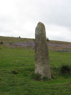
The track way passes through what remains of Mardon Down Stone Circle. On the left immediately before the stone circle is a cairn circle (Butler cairn 1). Mardon Down stone circle is the biggest on Dartmoor with a diameter of 38m which probably originally consisted of around 61 stones most of which have now disappeared although many are probably buried under the peat where they originally fell. Further north along the track are more cairns and the Giants Grave. The main track heads north-east at the Giant's Grave, instead continue on the minor path north to another cairn circle (Butler Cairn 5). This is an impressive cairn circle and could easily be mistaken for Mardon stone circle - the cairn circle is marked on the OS Okehampton and North Dartmoor Landranger Series map (Sheet 191) unlike the stone circle. From the cairn circle, head eastwards down hill to the Headless Cross (the Maximajor Stone). From here cut across the moor on the other side of the road by heading NE for about 200m to join the road to Clifford Bridge. It is a steep descent for 2km to reach Clifford Bridge. Over Clifford Bridge there is a crossroads - take the right turn. About 0.5km along the Dunsford road there is a gate on the right hand side for the walk through Dunsford Woods to Steps Bridge. This part of the walk follows the Teign for most of the route and is especially pleasant in the spring when the senses are treated to the sight of the bluebells and the fragrance of wild garlic. Dippers and grey wagtails are a common sight along this stretch of the Teign. The path ends just by Steps Bridge on the B3212. The bus stop is located a couple of hundred metres eastwards over the bridge in the parking area.
NOTE: The author has not yet walked this route. Instead a more arduous and complicated circular walk was used starting and finishing at Steps Bridge. The route taken was in the opposite direction and involved a strenuous climb up to Mardon Down from Clifford Bridge and then descending via the bridle path from the Headless Cross pass Leigh Farm down to the B3212 near Westcott. The route of the bridle path is clear on the map but becomes unmarked on the ground as it gets closer to the road and it is difficult to know, as you go through the gates of a few fields, whether or not you have remained on a public right of way. The walk suggested above has the advantage of clarity of route and of starting on high ground and descending down to Steps Bridge.
External Links
Legendary Dartmoor: The Maximajor Stone
Page last updated 22/8/11