
Langstone Moor 2 Stone Row
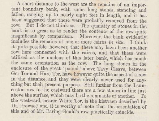
Worth, R.N., The Stone Rows of Dartmoor - Part 2, T.D.A. Vol.25 pp.541-546 (1893)
Database entries
OS Map: SX 54945 78842
OS Source: Google
HER: MDV4107
PMD: Langstone Moor 2
Alternate name: Langstone Moor II
Short Name: SR:Langstone 2
Butler map: 30.12
Exist: Yes
Record: Unique
Record Source: PMD
Hut Class: No
Lidar: SX 54945 78842
Guide Map: 24
Nearest Bus Stop: Merrivale Dartmoor Inn (4.8 km) [Route: 98,171(20/07/26 to 19/09/26)]
Nearby sites: SX 54945 78842
Notes
"Reave running from north - south on the eastern slopes of Whittor close to the Langstone Stone Row." Breton (p.17): Nearly parallel to it, and 60 yds away was another row.Sixth DEC Report (1895): Nearly parallel with the row, but not quite so, at the distance of sixty or seventy yards, are the remains of a second stone row, leading from a cairn, formerly surrounded by a circle of stones. A very ancient "new take" wall has been built over and about this line ; it includes the cairn in it, and takes advantage of some of the original standing stones.
R.N. Worth (1893): A short distance to the west are the remains of an important boundary bank, with some long stones, standing and fallen, ranging up to nearly eight feet in length, and it has been suggested that these were probably removed from the row. But I do not think so. The quantity of stones in the bank is so great as to render the contents of the row quite insignificant by comparison. Moreover, the bank evidently includes the remains of one or more cairns, in situ. I think it quite possible, however, that there may have been another row here connected with the cairns, and that these were utilised as the nucleus of this later bank, which has much the same orientation as the row. The long stones in the enclosure of the great, 'pound' above Tavy Cleave, between Ger Tor and Hare Tor, have however quite the aspect of a row in the distance, and they were clear1y, never used for anything but their present purpose.
References
These are selected references with an emphasis on out of copyright sources linked as PDFs. For more detailed references try any linked HER or PMD record above.
- Baring-Gould, Sabine, Second Report of the Dartmoor Exploration Committee, T.D.A. Vol.27 pp.81-92 (1895)
- Baring-Gould, Sabine, Sixth Report of the Dartmoor Exploration Committee, T.D.A. Vol.31 pp.146-155 (1899)
- Breton, Henry Hugh, The Heart of Dartmoor, (1926)
- Butler, Jeremy, Dartmoor Atlas of Antiquities, vol.2: The North, (1991)
- Fleming, Andrew, The prehistoric landscape of Dartmoor Part 1: South Dartmoor , Proceedings of the Prehistoric Society , Volume 44 , pp. 97 - 12 (1978)
- Grinsell, L.V., Dartmoor Barrows, Devon Archaeological Society Proceedings No.36 (1978)
- Newman, Phil, The Langstone Moor Stone Circle, Peter Tavy, Devon and its Prehistoric Environs, English Heritage (2003)
- Worth, R.N., The Stone Rows of Dartmoor - Part 2, T.D.A. Vol.25 pp.541-546 (1893)