
Langstone Moor Settlement

Photo taken on 25-07-2026
Database entries
OS Map: SX 555 779
OS Source: Estimate
HER: MDV4219
Megalithic Portal: 17507
Alternate name: Langstone Moor
Short Name: ST Langstone
Butler map: 30.2
Exist: Yes
Record: Unique
Record Source: PDW
Hut Class: No
Lidar: SX 555 779
Guide Map: 24
Nearest Bus Stop: Merrivale Dartmoor Inn (3.6 km) [Route: 98,171(20/07/26 to 19/09/26)]
Nearby sites: SX 555 779
Notes
HER: A complex hut settlement of at least 35 hut circles covering 4.7 hectares with many huts contained within small enclosures on Langstone Moor. 35 hut circles were positively identified with three possible hut circles and four very doubtful features. At least seven of the previously identified huts were found to be bulges in enclosure walls with no signs of having ever been huts. There is a group of seven hut circles to the west of the main settlement. This group includes one hut with an inner partition, two with only partial remains and a slight ring of stones which may be the remains of a hut circle.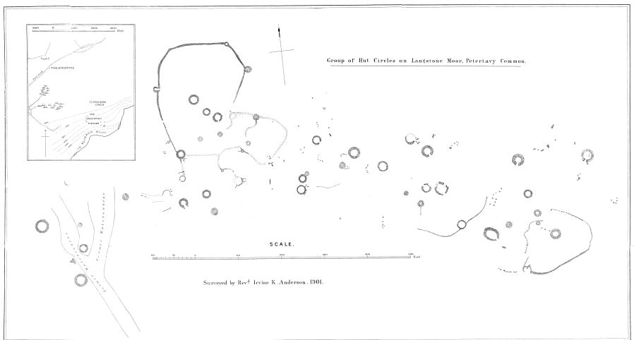
Plan by Rev Irvine K Anderson. DEC Report No. 7 1901
There are useful plans in Butler (1991) p.68, Newman (2003) Fig 2. and Gerrard (1997) p.114.
References
These are selected references with an emphasis on out of copyright sources linked as PDFs. For more detailed references try any linked HER or PMD record above.
- Baring-Gould, Sabine, Second Report of the Dartmoor Exploration Committee, T.D.A. Vol.27 pp.81-92 (1895)
- Baring-Gould, Sabine, Seventh Report of the Dartmoor Exploration Committee, T.D.A. Vol.33 pp.130-138 (1901)
- Butler, Jeremy, Dartmoor Atlas of Antiquities, vol.2: The North, (1991)
- Gerrard, Sandy, English Heritage Book of Dartmoor: Landscapes Through Time, (1997)
- Newman, Phil, The Langstone Moor Stone Circle, Peter Tavy, Devon and its Prehistoric Environs, English Heritage (2003)
- Newman, Phil, Archaeological Sites within Merrivale Training Area (2018), Southwest Landscape Investigations (2018)
- Newman, Phil, Archaeological Sites within Merrivale Training Area (2022), Southwest Landscape Investigations (2022)
- Worth, R. Hansford, The Dartmoor Hut Circles, T.D.A. Vol.77 pp.225-256 (1945)