
Guide to the Monuments on Cut Hill

Table of Ritual and Burial Monuments on Cut Hill
The following table lists the records currently in this Guide Map. For an explantion of the Guide Maps and a table of all 62 Guide Maps, follow this link: Guide List Table. Introductory text will be added to each guide list in 2025. Notes on duplication and omissions will appear below the table once checks have been finalised.
| Guide # | Butler | SiteID | Site Name | ShortName | Record Source | Map | Turner | HER | Photo | Unique? | Checked |
|---|---|---|---|---|---|---|---|---|---|---|---|
| 1 | 188 | Cut Hill Stone Row | SR Cut Hill | PDW | SX5987182756 | MDV69604 | Y | Unique | 1 | ||
| 2 | 464 | Cut Hill Cist | CT Cut Hill | HER | SX5981982707 | MDV134402 | Y | Unique | 1 | ||
| 3 | 39 | Cut Hill Cairn | CN Cut Hill | PDW | SX5982382745 | MDV69603 | Y | Unique | 1 | ||
| 4 | 4209 | Fur Tor Reported Cist | CT:Fur Tor | HER | SX5783083050 | MDV66000 | N | Unique | 1 |
Cut Hill Guide Map
Guidance for walkers: The monuments featured in this database are archaeological treasures and need to be protected and preserved - please do not disturb any sites. Please check access and firing times before visiting sites, not all sites listed are on open access land. Firing ranges and boundaries of open access areas are marked on the OL28 OS Dartmoor Explorer map. Please stick to the country code and consider giving support to the numerous agencies that help to keep Dartmoor a fabulous natural and historic environment!
List of Ritual and Burial Monuments on Cut Hill
Cut Hill Stone Row
OS Map: SX 59871 82756
HER record: MDV69604
Megalithic Portal: 25916
The Stone Rows of GB: Cut Hill
PMD: Cut Hill Stone Row
ShortName: SR Cut Hill
DPD page: 130
Notes: Discovered in 2004. Prehistoric stone row of 6-7 large granite slabs near the summit of Cut Hill. All the slabs are recumbent with one buried. The row is thought to date back earlier than 3,500BC. For more information, see: Cut Hill, Dartmoor (phase 3), Stone row chronology and landscape change, HER MDV69604 and Legendary Dartmoor
Nearby sites: SX59878276

Cut Hill Cist
OS Map: SX 59819 82707
HER record: MDV134402
ShortName: CT Cut Hill
Notes: "Potential early Bronze Age cist feature noted on Cut Hill in 2021. Charcoal from the site have been radiocarbon dated and the samples were dated to 1881 - 1698 cal BC (3831 - 3648 cal BP). Subsequent pollen analysis has confirmed likely prehistoric origins for this feature, which is not of natural origin, as well as noting the construction of the feature took place at a time when the local area was characterised as open heath-type vegetation."
Nearby sites: SX59828271

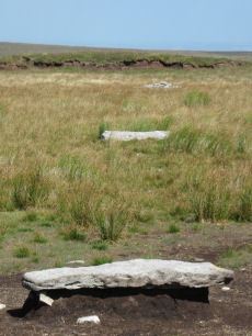
Cut Hill Cairn
OS Map: SX 59823 82745
HER record: MDV69603
Megalithic Portal: 47078
PMD: Cut Hill
ShortName: CN Cut Hill
DPD page: 130
Notes: "Barrow c20m overall diameter on the top of 'Cut Hill' at 603m OD was observed during a field visit by Tom Greeves in 2004. The 1.5m high circular mound has a military range pole set in it & surface erosion has exposed a turf/peat core with a few stones. The surrounding ditch is over 1m wide & nearly filled with waterlogged vegetation."
Nearby sites: SX59828275
Fur Tor Reported Cist
OS Map: SX 57830 83050
HER record: MDV66000
ShortName: CT:Fur Tor
Notes: Cairn with cist approx 1km w of fur tor.
Nearby sites: SX57838305
Page last updated 10/12/24