
Guide to the Monuments on Sittaford

Table of Ritual and Burial Monuments on Sittaford
The following table lists the records currently in this Guide Map. For an explantion of the Guide Maps and a table of all 62 Guide Maps, follow this link: Guide List Table. Introductory text will be added to each guide list in 2025. Notes on duplication and omissions will appear below the table once checks have been finalised.
Sittaford Guide Map
Guidance for walkers: The monuments featured in this database are archaeological treasures and need to be protected and preserved - please do not disturb any sites. Please check access and firing times before visiting sites, not all sites listed are on open access land. Firing ranges and boundaries of open access areas are marked on the OL28 OS Dartmoor Explorer map. Please stick to the country code and consider giving support to the numerous agencies that help to keep Dartmoor a fabulous natural and historic environment!
List of Ritual and Burial Monuments on Sittaford
Quintins Man Cairn
OS Map: SX 62101 83873
HER record: MDV6765
Megalithic Portal: 45860
PMD: Quintins Man
ShortName: SSxQuintinsMan
Butler map: 34.1
Notes: "A cairn. The name implies a standing stone, but there is no knowledge of one in living memory." [worth] See also, Legendary Dartmoor: Dartmoor's Quintin's Man
Nearby sites: SX62108387
Quintins Man Cairn
OS Map: SX 62101 83872
HER record: MDV6765
ShortName: CN:Quintins 1
Butler map: 34.1
Grinsell: LYD 15
Notes: "Quintin's man; the placename seems to indicate the existence of a menhir, but the object to which it is applied is to a cairn. No record of a menhir standing by a cairn." Cairn (heig 1.83m, diam 20.1m).
Nearby sites: SX62108387
Quintins Man (Near) Reported Cairn
OS Map: SX 62120 83840
HER record: MDV13033
ShortName: CN?Quintins 2
Butler map: 34.1
Grinsell: LYD 15a
Notes: Grid reference from Grinsell. Built over. The area immediately to the south-east of Quintin's Man is now occupied by Ministry of Defence buildings which have probably obscured this alleged cairn.
Nearby sites: SX62128384
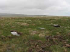
Quintins Man A Ancient Pool
OS Map: SX 62102 83952
HER record: MDV27278
ShortName: PO Quintins A
Notes: "Previously identified as a prehistoric barrow, survey work in 1995 suggested this to be a natural feature. One of over 40 'sacred' pools identified by Greeves (2019) that may have prehistoric origin. Lies north of the Quintin's Man cairn."
Nearby sites: SX62108395
Quintins Man B Ancient Pool
OS Map: SX 62053 84056
HER record: MDV127217
ShortName: PO Quintins B
Notes: "A pool measuring 20 by 16m. One of over 40 such 'sacred' pools identified on Dartmoor that are thought to have potentially been designed during the prehistoric period."
Nearby sites: SX62058406
Quintins Man C Ancient Pool
OS Map: SX 61972 84365
HER record: MDV127218
ShortName: PO Quintins C
Notes: "Pool north of Quintin's Man measures 12 by 8m. One of over 40 such 'sacred' pools identified on Dartmoor that are thought to have potentially been designed during the prehistoric period"
Nearby sites: SX61978437
Teignhead Newtake 1 Reported Cairn
OS Map: SX 62500 84500
HER record: MDV6796
ShortName: CN?Teignhead 1
Butler map: 34.1.1
Grinsell: LYD 15b
Notes: Excavated by Burnard 1902. Can no longer be traced. Grinsell rough estimate of location 625845 Grid reference, guess by Grinsell
Nearby sites: SX62508450
Teignhead Newtake 2 Reported Cairn
OS Map: SX 62500 84500
HER record: MDV6796
ShortName: CN?Teignhead 2
Butler map: 34.1.2
Grinsell: LYD 15c
Notes: Excavated by Burnard 1902. Can no longer be traced. Grinsell rough estimate of location 625845 Grid reference, guess by Grinsell
Nearby sites: SX62508450
Teignhead Newtake 2 (duplicate) Reported Cairn
OS Map: SX 62500 84500
HER record: MDV54673
ShortName: CN:TeignHdDup
Notes: Duplicate of HER 6796
Nearby sites: SX62508450
Marsh Hill Reported Cairn
OS Map: SX 62150 82427
HER record: MDV6776
PMD: Statt's House
ShortName: CT?Marsh Hill
Butler map: 34.2
Grinsell: LYD 34
Notes: Possible cairn but thought to have been the remains of a collapsed house similar to Stat's House a few metres to the north. The mound has been much disturbed by the construction of a shelter in its centre. This is a trapezoidal structure, 1.2m wide at its northwestern end, 1.7m wide at its northeastern end and 3.1m long. The coursed walls are 1.1m wide and 0.6m high. The slab inside the shelter represents tumble from this structure rather than part of a cist as suggested by Grinsell.
Nearby sites: SX62158243
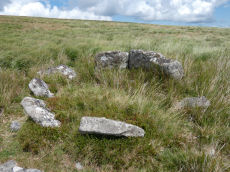
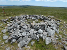
Sittaford Tor Ring Setting Cairn and Cist
OS Map: SX 63479 82641
HER record: MDV21894
Megalithic Portal: 45792
PMD: Sittaford Tor
Alternate name: Sittaford Tor S. Ring Setting Cairn and Cist
ShortName: CT Sittaford
Butler map: 34.3
Butler Vol 5: p.183 & Fig.126
DPD page: 125
Turner: D25
Notes: "Cairn 5 metres in diameter, 0.75 metres high. Surrounded by two rings of kerb stones up to 0.75 metres high. Many stones forming the outer ring are recumbent. Mound material up to 0.2 metres high. Inner kerb is 2.8 metres diameter and the outer is 5 metres diameter. Slab in centre may be an intact cist. Grass and rushes. Animal poaching on western side of cairn.". "This mutilated kerbed cairn is situated on a peat-covered moorland slope below Sittaford Tor at 488m OD. It measures about 5m in diameter and comprises a probably (hidden) central cist set within twin concentric kerbs of granite slabs." Lethbridge photo bottom p.125. Butler Sittaford Tor S (Cairn 3) Vol. 2. Map 34.3 (p.112, also Butler Vol. 5. diagram p.183).
Nearby sites: SX63488264
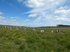
Sittaford Stone Circle
OS Map: SX 63017 82814
HER record: MDV110432
Megalithic Portal: 35327
PMD: Sittaford Tor
ShortName: SC Sittaford
Notes: Discovered by Alan Endacott in 2007 as described in Devon Archaeological Society Newsletter No. 117 January 2014. Circle consists of 30 recumbent stones and has a diameter of 32m. It is about 1km from the Grey Wethers which are to the ENE. It is on the same arc as the previously known circles in northeastern Dartmoor.
Nearby sites: SX63028281
Sittaford Circle Outlier Standing Stone
OS Map: SX 63053 82805
HER record: MDV110432
Megalithic Portal: 35327
ShortName: SS Sittaford
Notes: Sittaford Circle Outlier
Nearby sites: SX63058281
Lade Hill Brookhead Reported Cairn
OS Map: SX 63800 82400
HER record: MDV6792
ShortName: CN?Lade Hill
Butler map: 35.9
Grinsell: LYD 16a
Notes: A barrow 700 yards south of Grey Wethers (SX 68 SW 1) (which plots somewhere amongst the hut circles). It measures 16ft diameter and 9 ins high. Excavations in 1897/8 exposed a pit containing a little charcoal. No longer traceable.
Nearby sites: SX63808240
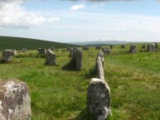
Grey Wethers (N) Stone Circle
OS Map: SX 63875 83161
HER record: MDV6758
Megalithic Portal: 532
PMD: Grey Wethers Stone Circles
ShortName: SC Grey Weth N
DPD page: 134
Turner: G4
Notes: "Northern stone circle of the pair known collectively as The Grey Wethers. This circle measures 31.5 metres in diameter and is denoted by 20 upright granite slabs with an average height of 1.1 metres. Excavations carried out by the Dartmoor Exploration Committee towards the end of the 19th century revealed a layer of charcoal covering the original ground surface. A shallow trench visible leading through the southern circle may be the result of this excavation. The circle was restored at this time"
Grinsell [Folklore 1976]: The stones turn round at sunrise. King 1873, 780; St Leger Gordon 1972, 71-2.
Nearby sites: SX63888316
Grey Wethers (S) Stone Circle
OS Map: SX 63874 83121
HER record: MDV6759
Megalithic Portal: 532
PMD: Grey Wethers Stone Circles
ShortName: SC Grey Weth S
DPD page: 134
Turner: G2
Notes: This site is one of the most impressive on Dartmoor. The circles were restored in 1909 by Burnard. At the time only 9 stones remained standing in the north circle and 7 in the south circle. It is thought that the reconstruction is fairly accurate. The circles are separated by a few meters and are almost identical. Both circles have 30 stones and diameters very close to 33 m and they are within 2 degrees of being on an exact north to south alignment. The slight differences between the two circles could even be a result of the restoration. Apparently "wether" is an old English name for sheep and legend has it that a drunken farmer leaving the Warren House Inn was persuaded that the Grey Wethers were a desirable flock for sale! See also, Legendary Dartmoor: Grey Wethers
Grinsell [Folklore 1976]: The stones turn round at sunrise. King 1873, 780; St Leger Gordon 1972, 71-2.
Nearby sites: SX63878312
Grey Wethers E.1 Cairn
OS Map: SX 64110 83210
HER record: MDV6806
ShortName: CN:Grey Weth 1
Butler map: 35.16
Grinsell: LYD 16
Notes: "A barrow is situated 274m e of grey wethers. Excavations in 1897/8 exposed a pit containing a little charcoal (baring-gould)." Fifth Report of the dartmoor Exploraion Committee
Nearby sites: SX64118321
Grey Wethers E.2 Cairn
OS Map: SX 64268 83305
HER record: MDV20917
ShortName: CN:Grey Weth 2
Notes: large circular prehistoric cairn east of grey wethers. It is visible on the ridge from the stone circle. Possible stony ring bank with central cairn mound or ring. A small conventional cairn lies adjacent to it on its ne side.
Nearby sites: SX64278331
Grey Wethers E.3 Reported Cairn
OS Map: SX 64310 83290
HER record: MDV20909
ShortName: CN:Grey Weth 3
Notes: Duplicate of HER 6806
Nearby sites: SX64318329
Grey Wethers E.1 (duplicate) Reported Cairn
OS Map: SX 64401 83398
HER record: MDV6766
ShortName: CN?Weth1dup
Notes: possible barrow. Vegetation bank shown in dry weather. Approximately 25ft across, 1ft high.
Nearby sites: SX64408340
Sittaford Tor Pound
OS Map: SX 64000 82870
HER record: MDV6754
Megalithic Portal: 23218
ShortName: PD:Sittaford
Notes: "An oval enclosure lying within Great Stannon Newtake. It is defined by a 4.5m wide and 1.2m high rubble bank surrounding an internal area measuring 53.5m east to west by 39m north to south. An 8.3 metre wide entrance gap on the eastern side by a stony mound. The considerable size of the bank combined with its proximity to a number of ritual monuments within Great Stannon Newtake strongly supports that this enclosure is much more likely to have been used for ritual than domestic purposes and it has consequently been identified as a henge."
Nearby sites: SX64008287
South Teignhead Platform Cairn Circle
OS Map: SX 64084 82827
HER record: MDV20908
Megalithic Portal: 45611
PMD: South Teignhead
ShortName: PC S Teignhead
Butler map: 35.17
Butler Vol 5: p.157
Turner: E4
Notes: Oval cairn measuring 12.0m x 8.0m. It is flat-topped apart from a slight hollow in the centre. It appears to have multiple concentric rings of spaced small stones set on edge, with at least six rings being visible on its north side. To the south-east some stones are set at right angles to the rings. Butler in Volume 5 p.157 refers to a 14 x 6 m long cairn on the southern slopes of White Ridge. Presumably he refers to this site.
Nearby sites: SX64088283

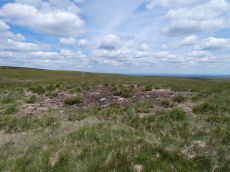
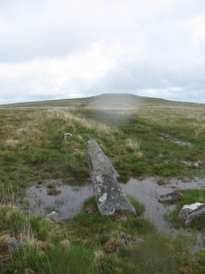
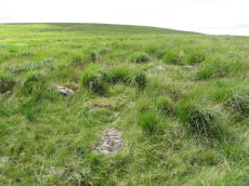
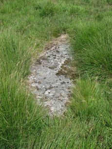
South Teignhead / White Ridge Stone Ring Cairn Circle
OS Map: SX 64168 82656
HER record: MDV6771
Megalithic Portal: 35830
PMD: Teignhead Henge
Alternate name: South Teignhead Pound Stone Ring Cairn Circle
ShortName: RC White Ridge
Butler map: 35.18
Turner: A5
Notes: A small circular 'pound' about 0.5km SE of Grey Wethers. It measures 75ft (N-S) by 66ft; the bank composed of small stone and earth is 6-8ft wide and 3ft high. An entrance on the W has one door jamb standing. Turner listed this as a ring cairn A5 but also suggested it as a possible henge monument.
The author revisited this site with Steve Szypko on 16/05/25. It is hard to find so the photo has been annotated with a red highlight to bring out the feature, Steve stands to the side giving scale.
Nearby sites: SX64178266
White Ridge Standing Stone
OS Map: SX 64162 82653
HER record: MDV6771
Megalithic Portal: 51338
PMD: South Teignhead
Alternate name: South Teignhead Standing Stone
ShortName: SS White Ridge
Butler map: 35.18
Notes: Possible recumbent standing stone. "A small circular 'pound' about 350 yards (sic) SE of Grey Wethers. It measures 75ft (N-S) by 66ft; the bank composed of small stone and earth is 6-8ft wide and 3ft high. An entrance on the W has one door jamb standing; this was excavated but nothing was found except a very fine flat stone on the subsoil which measured 9ft long by 3-4ft wide. Trial pits were dug inside the enclosure without success." TDA Vol. 34 pp.164 (1902)
Nearby sites: SX64168265
Manga Brook Crop Mark
OS Map: SX 63050 84780
HER record: MDV27298
ShortName: CN?Manga Brook
Notes: Aerial Photograph
Nearby sites: SX63058478
Langridge Newtake Cairn
OS Map: SX 64200 84760
HER record: MDV54686
ShortName: CN:Langridge
Nearby sites: SX64208476
Whitehorse Hill Reported Stone Circle
OS Map: SX 62208 84940
HER record: MDV130871
ShortName: SC:Whitehorse
Notes: "Possible features stone circle and row noted by Hemery (1983), though unconfirmed. Visited with DNPA archaeologist in April 2021. In a very ruinous condition with vegetation covering the majority of the ?stone row."
Nearby sites: SX62218494
Whitehorse Hill Reported Stone Row
OS Map: SX 62208 84938
HER record: MDV130871
ShortName: SR:Whitehorse
Notes: Hemery, E., 1983, High Dartmoor, 779-780 (Monograph). Hemery notes set stones representing ?stone circle and single ?row south at the end of the Sand Path; more stones southward may be part of same alignment. Possible identification of a retaining-circle. Possible extension of alignment in the form of spaced, fallen stones, to a point beyond a military range-pole. Inconclusive (much interference by turf-cutters) but may be candidate at approximately 1,840 feet above sea level to qualify as the highest placed on Dartmoor.
Cunis, E, 2021, Identification of possible circle/row on Whitehorse Hill (Correspondence). (14/04/2021) SX 62208 84938 Possible features recorded on Whitehorse Hill - standing and recumbent stones; Stone Circle and Row? Visited with DNPA archaeologist in April 2021. In a very ruinous condition with vegetation covering the majority of the ?stone row. Ground evidence noted by Eric Hemery (likely 1950s and 1980s to check again before publication).
Nearby sites: SX62218494
Page last updated 10/12/24