
Prehistoric sites within 2km of SX 63880 83160
Guidance for walkers: The monuments featured in this database are archaeological treasures and need to be protected and preserved - please do not disturb any sites. Please check access and firing times before visiting sites, not all sites listed are on open access land. Firing ranges and boundaries of open access areas are marked on the OL28 OS Dartmoor Explorer map. Please stick to the country code and consider giving support to the numerous agencies that help to keep Dartmoor a fabulous natural and historic environment!
About the database listings: In all listings clicking on the photo or the site name will open a page for the site with a larger photo and further details from the database. The database now has over 6680 records covering nearly all publicly listed sites on Dartmoor including around 4800 round houses. This level of detail is of interest to archaeologists but tends to swamp listings of sites more likely to be of interest for walkers. For this reason, the listings default to around 550 core sites only. These are the stone circles, stone rows and the ring cairns listed by Turner. The default search radius is 2 km. The controls below the map can be used to start a new search by entering a 6- or 8-digit reference (without the prefix "SX"). The search radius can be specified and you can add incremental Display layers of detail on top of the core sites. If using a more detailed layer you will need to decrease the search radius to avoid getting hundreds of search results.
- Core sites Default listing of core sites consisting of stone circles & rows and some of the major ring cairns.
- Plus cairns adds approx. 1000 cairns and other minor sites not included in the core listings but excluding round houses.
- Plus round houses adds approx. 4800 round houses.
- Plus non-sites adds in the records for sites that no longer exist or are not prehistoric sites.
- Plus duplicates adds records excluded as duplicates. Those maybe duplicate records in external listings (e.g. the Historic Environment Records). For example, some sites have been identified as cairns in some listings and interpreted as round houses in other listings and both records appear.
These listings have incorporated, matched up and merged all of the records from all of the major archaeological listings including: Worth, Grinsell, Turner, Butler, Bill Radcliffe, Sandy Gerrard, Megalithic Portal, the National Monument Records and the Historic Environment Records. The author would like to thank Bill, Sandy, the lovely people both at Megalithic Portal (especially Anne Tate who did an amazing job to link listings) and at ACE Archaeology for collaborative work over the years to synchronise and correct listings across the various websites which now interlink. A culmination of years of work the final merger of cairn records took 3 months of cross referencing in 2017 the result being a snapshot of the records at that time. This data has in turn been refined since by field work and research. The round house data was supplied by Sandy Gerrard. Grid references are in order of accuracy: from Google Earth satellite, if visible and found, from a Garmin GPS reading, if visited by the author and from the literature otherwise. Individual site pages will state the source of the grid reference and provide satellite imagery. If a site listing lacks a photo it has not yet been visited by the author in which case the grid reference is from the literature.
Currently the database only includes sites which can be represented by a grid reference. Reaves are not included as they require GIS shape technology which is beyond the current capability of this system. To see the sources for the records, look at the tables on the resources menu. The database listings can also be viewed on a Google map and downloaded as GPS datasets for Garmin devices.
Corrections, or any feedback or suggestions are very welcome, email: info@dartmoorwalks.org.uk.
NOTE: Clicking on the icons for each monument in the map will give the name of the site. You can zoom in and out and drag the map around.
List of sites within 2km of SX 63880 83160
Fernworthy Stone Circle
Prehistoric Dartmoor Walks: Dartmoor Site: Fernworthy Ceremonial Complex
OS Map: SX 65486 84126
HER: MDV6534
Megalithic Portal: 530
PMD: Fernworthy Stone Circle
ShortName: SC Fernworthy
DPD page: 138
Turner: G13
Notes: The Fernworthy circle is part of a group of ceremonial monuments including 3 stone rows and 5 cairns that may once have rivalled Merrivale and Shovel Down as ceremonial centres. The site is in a small clearing in Fernworthy Forrest off the path to Teignhead Farm. The circle is remarkably intact with all but 2 stones still in their original places ... It is 20m in diameter and consists of 27 small stones. The stone rows and cairns probably came later and surround the site. The circle was excavated by the Dartmoor Exploration Committee in 1897. They found that the interior of the circle was covered in a layer of charcoal suggesting that it had been the scene of very many fires - perhaps funeral pyres or feasts. See also Legendary Dartmoor: Dartmoor's Fernworthy Stone. DNP Post 3D. Breton p.66-67
Nearby sites: SX 65486 84126
Distance: 1.87km
Fernworthy Ceremonial Complex
Prehistoric Dartmoor Walks: Dartmoor Site: Fernworthy Ceremonial Complex
OS Map: SX 6548 8412
HER: MDV6534
Megalithic Portal: 35937
PMD: Fernworthy
ShortName: CX Fernworthy
DPD page: 138
Notes: Lethbridge p.138. Breton p.66-67.
Nearby sites: SX 6548 8412
Distance: 1.87km
Fernworthy Settlement
OS Map: SX 648 837
HER: MDV6731
Megalithic Portal: 10485
ShortName: ST:Fernworthy
Nearby sites: SX 648 837
Distance: 1.07km

Fernworthy Cist
Prehistoric Dartmoor Walks: Dartmoor Site: Fernworthy Ceremonial Complex
OS Map: SX 65491 84100
HER: MDV6719
Megalithic Portal: 35826
PMD: Fernworthy
Alternate name: Fernworthy 2 Cist
ShortName: CT Fernworth 2
Butler map: 35.15.2
Butler Vol 5: p.36 & Fig.13
DPD page: 138
Grinsell: LYD 23
Notes: The remains of this cist are in the 6m diameter barrow at the N end of the Fernworthy S.E. stone row. The cist in the centre is represented by two stones set at right angles, 0.4m tall internally. Excavated by the Dartmoor Excavation Committee in 1898. A lot of burnt bone was found. DNP Post 6D. Butler Vol. 2. Map 35.15.2 (diagram Vol. 5. p.36 - row 2). Newman Barrow B.
Nearby sites: SX 65491 84100
Distance: 1.87km
Fernworthy (SW) Encircled Cairn
Prehistoric Dartmoor Walks: Dartmoor Site: Fernworthy Ceremonial Complex
OS Map: SX 65483 84101
HER: MDV14885
Megalithic Portal: 35827
Alternate name: Fernworthy 3 Encircled Cairn
ShortName: EC Fernworth 3
Butler map: 35.15.3
Butler Vol 5: p.36 & Fig.14
Grinsell: LYD 21
Turner: F25
Notes: Newman Barrow A. Small turf-covered cairn at the northern end of the western double stone row south of Fernworthy stone circle forming part of the Froggymead ceremonial complex. It measures 6.5 metres in diameter and has a central hollow resulting from excavation in 1898. Two rings of orthostats, 7m and 5m diameter, around cairn 4.5m diameter and 0.2m high (Turner). It once had a retaining circle of small stones but only three were visible in 2013. DNP Post 2D. Turner F25.
Nearby sites: SX 65483 84101
Distance: 1.86km

Fernworthy Barrow C Cairn
OS Map: SX 65485 84047
HER: MDV14887
Megalithic Portal: 35829
Alternate name: Fernworthy 4 Cairn
ShortName: CN:Fernworth 4
Butler map: 35.15.4
Grinsell: LYD 22
Notes: Newman Barrow C.Cairn forming part of the cermonial complex at Froggymeade. Sitated at the southern end of the eastern stone row to the south of Fernworthy stone circle. It was excavated in 1898 but had previously been disturbed. Only one small flint flake was found.
Nearby sites: SX 65485 84047
Distance: 1.83km

Fernworthy E. Encircled Cairn
Prehistoric Dartmoor Walks: Dartmoor Site: Fernworthy Ceremonial Complex
OS Map: SX 65561 84090
HER: MDV6560
Megalithic Portal: 3234
Alternate name: Fernworthy 5 Encircled Cairn
ShortName: EC:Fernworth 5
Butler map: 35.15.5
DPD page: 138
Grinsell: LYD 24
Turner: F4
Notes: Newman Barrow D. "5.8m diameter. Has 3 stones spaced on the east side. A beaker, flint knife, dress fastener and a piece of bronze were discovered when the cairn was excavated in 1898". The crushed beaker. When reconstructed it became one of Dartmoor's most important Bronze Age finds and is now on display in Plymouth City Museum along with the other artifacts retrieved. DNP Post 7D.
Nearby sites: SX 65561 84090
Distance: 1.92km
Fernworthy S.E. Stone Row
Prehistoric Dartmoor Walks: Dartmoor Site: Fernworthy Ceremonial Complex
OS Map: SX 6549 8407
HER: MDV6556
Megalithic Portal: 10484
The Stone Rows of GB: Fernworthy 2
PMD: Fernworthy C Stone Row
Alternate name: Fernworthy 2 Stone Row
ShortName: SR Fernwthy SE
Butler map: 35.15.2
DPD page: 138
Notes: Butler Row 2. "Centred at SX 65518404 is a cairn. 45m to the N at SX 65508409 is a barrow containing the remains of a cist. Between the two are the very fragmented remains of an alleged double stone row running N to S parallel to another row (SX 68 SE 59) which leads towards Fernworthy Stone Circle. The row, barrow and cairn have all been comprehensively damaged by afforestation and the digging of the adjacent drainage channels. Seven stones survive of an alignment but there is little evidence that it was a double row. The barrow at the N end of the row measures up to 6m in diameter and is 0.4m high, although its shape is obscured by drainage channels. The cist in the centre is represented by two stones set at right angles, 0.4m tall internally. The cairn at the S end of the row measures 7.3m N to S by 8.5m and is 0.5m high. There is a large amount of surface stone on and around it." DNP Post 5D.
Nearby sites: SX 6549 8407
Distance: 1.85km
Fernworthy S.W. Stone Row
Prehistoric Dartmoor Walks: Dartmoor Site: Fernworthy Ceremonial Complex
OS Map: SX 65479 84105
HER: MDV14886
Megalithic Portal: 1934
The Stone Rows of GB: Fernworthy 3
PMD: Fernworthy A Stone Row
Alternate name: Fernworthy 3 Stone Row
ShortName: SR Fernwthy SW
Butler map: 35.15.3
DPD page: 138
Notes: Butler Row 3. "A disturbed double stone row is centred SX 65488408. It is 21m long and is oriented N to S. At the N end is a cairn (SX 68 SE 58) offset slightly W of the alignment of the row. Beyond this to the N is Fernworthy Stone Circle (SX 68 SE 56). The S end of the row is not very well preserved. The plan of 1898 depicts it terminating at a stone in the face of a wall, although the wall has since been removed. The stones in the row average 0.5m to 0.6m tall and lie in an area of amorphous modern earthworks up to 0.3m deep." DNP Post 1D. Breton p.67.
Nearby sites: SX 65479 84105
Distance: 1.86km
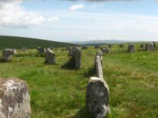
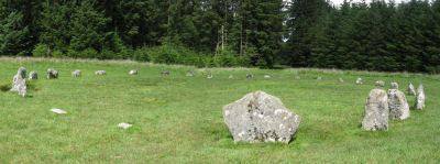
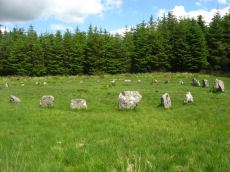
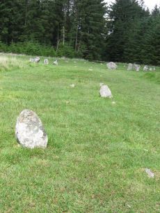
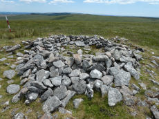
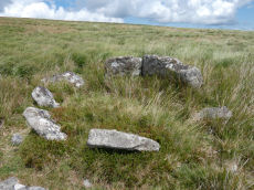
Grey Wethers (N) Stone Circle
Prehistoric Dartmoor Walks: Dartmoor Site: Grey Wethers Double Stone Circle
OS Map: SX 63875 83161
HER: MDV6758
Megalithic Portal: 532
PMD: Grey Wethers Stone Circles
ShortName: SC Grey Weth N
DPD page: 134
Turner: G4
Notes: "Northern stone circle of the pair known collectively as The Grey Wethers. This circle measures 31.5 metres in diameter and is denoted by 20 upright granite slabs with an average height of 1.1 metres. Excavations carried out by the Dartmoor Exploration Committee towards the end of the 19th century revealed a layer of charcoal covering the original ground surface. A shallow trench visible leading through the southern circle may be the result of this excavation. The circle was restored at this time"
Grinsell [Folklore 1976]: The stones turn round at sunrise. King 1873, 780; St Leger Gordon 1972, 71-2.
Nearby sites: SX 63875 83161
Distance: 0.01km
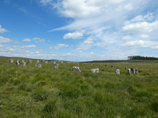
Grey Wethers (S) Stone Circle
Prehistoric Dartmoor Walks: Dartmoor Site: Grey Wethers Double Stone Circle
OS Map: SX 63874 83121
HER: MDV6759
Megalithic Portal: 532
PMD: Grey Wethers Stone Circles
ShortName: SC Grey Weth S
DPD page: 134
Turner: G2
Notes: This site is one of the most impressive on Dartmoor. The circles were restored in 1909 by Burnard. At the time only 9 stones remained standing in the north circle and 7 in the south circle. It is thought that the reconstruction is fairly accurate. The circles are separated by a few meters and are almost identical. Both circles have 30 stones and diameters very close to 33 m and they are within 2 degrees of being on an exact north to south alignment. The slight differences between the two circles could even be a result of the restoration. Apparently "wether" is an old English name for sheep and legend has it that a drunken farmer leaving the Warren House Inn was persuaded that the Grey Wethers were a desirable flock for sale! See also, Legendary Dartmoor: Grey Wethers
Grinsell [Folklore 1976]: The stones turn round at sunrise. King 1873, 780; St Leger Gordon 1972, 71-2.
Nearby sites: SX 63874 83121
Distance: 0.04km
Hemstone Rocks Platform Cairn Circle
OS Map: SX 64856 83806
HER: MDV6730
Megalithic Portal: 45619
PMD: Hemstone Rocks
Alternate name: Hemstone Rocks N.3 Platform Cairn Circle
ShortName: PC Hemstone N3
Butler map: 35.7.3
Grinsell: LYD 17b
Turner: E12
Notes: Next to Turner ring cairn D9. "Remains of a cairn 8.0 metres diameter and up to 0.2 metres high to the north of the hut settlement. There are two pits cut into it, probably the result of work carried out by the Dartmoor Exploration Committee in 1901." DNP Site 9F.
Nearby sites: SX 64856 83806
Distance: 1.17km
Hemstone Rocks Ring Setting Cairn and Cist
OS Map: SX 64852 83850
HER: MDV6729
Megalithic Portal: 52522
PMD: Hemstone Rocks
Alternate name: Hemstone Rocks N.2 Ring Setting Cairn and Cist
ShortName: CT Hemstone N2
Butler map: 35.7.2
Grinsell: LYD 17a
Turner: D9
Notes: There are 3 cairns in the vicinity and they are according to Newman [2013] impossible to match up with the old reports. These cairns were excavated by Baring-Gould in 1900. A flint flake was found in the cist. There is also a rectangular pit in this cairn which could be from the 1900 excavation. See also: MDV48854. DNP Site 8F. Butler Hemstone Rocks N. 1 - Vol. 2. Map 35.7. Central cist. Next to Turner Platform Circle E12.
Nearby sites: SX 64852 83850
Distance: 1.19km
Quintins Man Cairn
OS Map: SX 62101 83873
HER: MDV6765
Megalithic Portal: 45860
PMD: Quintins Man
ShortName: SSxQuintinsMan
Butler map: 34.1
Notes: "A cairn. The name implies a standing stone, but there is no knowledge of one in living memory." [worth] See also, Legendary Dartmoor: Dartmoor's Quintin's Man
Nearby sites: SX 62101 83873
Distance: 1.92km
Quintins Man A Ancient Pool
OS Map: SX 62102 83952
HER: MDV27278
ShortName: PO Quintins A
Notes: "Previously identified as a prehistoric barrow, survey work in 1995 suggested this to be a natural feature. One of over 40 'sacred' pools identified by Greeves (2019) that may have prehistoric origin. Lies north of the Quintin's Man cairn."
Nearby sites: SX 62102 83952
Distance: 1.95km
Sittaford Stone Circle
OS Map: SX 63017 82814
HER: MDV110432
Megalithic Portal: 35327
PMD: Sittaford Tor
ShortName: SC Sittaford
Notes: Discovered by Alan Endacott in 2007 as described in Devon Archaeological Society Newsletter No. 117 January 2014. Circle consists of 30 recumbent stones and has a diameter of 32m. It is about 1km from the Grey Wethers which are to the ENE. It is on the same arc as the previously known circles in northeastern Dartmoor.
Nearby sites: SX 63017 82814
Distance: 0.93km
Sittaford Tor Pound
OS Map: SX 6400 8287
HER: MDV6754
Megalithic Portal: 23218
ShortName: PD:Sittaford
Notes: "An oval enclosure lying within Great Stannon Newtake. It is defined by a 4.5m wide and 1.2m high rubble bank surrounding an internal area measuring 53.5m east to west by 39m north to south. An 8.3 metre wide entrance gap on the eastern side by a stony mound. The considerable size of the bank combined with its proximity to a number of ritual monuments within Great Stannon Newtake strongly supports that this enclosure is much more likely to have been used for ritual than domestic purposes and it has consequently been identified as a henge."
Nearby sites: SX 6400 8287
Distance: 0.31km
Sittaford Tor Ring Setting Cairn and Cist
OS Map: SX 63479 82641
HER: MDV21894
Megalithic Portal: 45792
PMD: Sittaford Tor
Alternate name: Sittaford Tor S. Ring Setting Cairn and Cist
ShortName: CT Sittaford
Butler map: 34.3
Butler Vol 5: p.183 & Fig.126
DPD page: 125
Turner: D25
Notes: "Cairn 5 metres in diameter, 0.75 metres high. Surrounded by two rings of kerb stones up to 0.75 metres high. Many stones forming the outer ring are recumbent. Mound material up to 0.2 metres high. Inner kerb is 2.8 metres diameter and the outer is 5 metres diameter. Slab in centre may be an intact cist. Grass and rushes. Animal poaching on western side of cairn.". "This mutilated kerbed cairn is situated on a peat-covered moorland slope below Sittaford Tor at 488m OD. It measures about 5m in diameter and comprises a probably (hidden) central cist set within twin concentric kerbs of granite slabs." Lethbridge photo bottom p.125. Butler Sittaford Tor S (Cairn 3) Vol. 2. Map 34.3 (p.112, also Butler Vol. 5. diagram p.183).
Nearby sites: SX 63479 82641
Distance: 0.66km
South Teignhead Platform Cairn Circle
OS Map: SX 64084 82827
HER: MDV20908
Megalithic Portal: 45611
PMD: South Teignhead
ShortName: PC S Teignhead
Butler map: 35.17
Butler Vol 5: p.157
Turner: E4
Notes: Oval cairn measuring 12.0m x 8.0m. It is flat-topped apart from a slight hollow in the centre. It appears to have multiple concentric rings of spaced small stones set on edge, with at least six rings being visible on its north side. To the south-east some stones are set at right angles to the rings. Butler in Volume 5 p.157 refers to a 14 x 6 m long cairn on the southern slopes of White Ridge. Presumably he refers to this site.
Nearby sites: SX 64084 82827
Distance: 0.39km

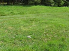
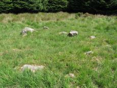
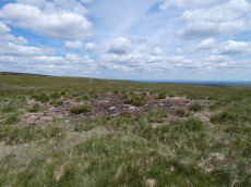
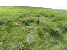
South Teignhead / White Ridge Stone Ring Cairn Circle
OS Map: SX 64168 82656
HER: MDV6771
Megalithic Portal: 35830
PMD: Teignhead Henge
Alternate name: South Teignhead Pound Stone Ring Cairn Circle
ShortName: RC White Ridge
Butler map: 35.18
Turner: A5
Notes: A small circular 'pound' about 0.5km SE of Grey Wethers. It measures 75ft (N-S) by 66ft; the bank composed of small stone and earth is 6-8ft wide and 3ft high. An entrance on the W has one door jamb standing. Turner listed this as a ring cairn A5 but also suggested it as a possible henge monument.
The author revisited this site with Steve Szypko on 16/05/25. It is hard to find so the photo has been annotated with a red highlight to bring out the feature, Steve stands to the side giving scale.
Nearby sites: SX 64168 82656
Distance: 0.58km
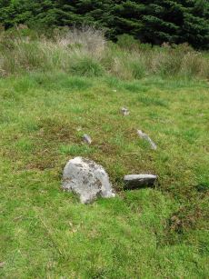
White Ridge Standing Stone
OS Map: SX 64162 82653
HER: MDV6771
Megalithic Portal: 51338
PMD: South Teignhead
Alternate name: South Teignhead Standing Stone
ShortName: SS White Ridge
Butler map: 35.18
Notes: Possible recumbent standing stone. "A small circular 'pound' about 350 yards (sic) SE of Grey Wethers. It measures 75ft (N-S) by 66ft; the bank composed of small stone and earth is 6-8ft wide and 3ft high. An entrance on the W has one door jamb standing; this was excavated but nothing was found except a very fine flat stone on the subsoil which measured 9ft long by 3-4ft wide. Trial pits were dug inside the enclosure without success." TDA Vol. 34 pp.164 (1902)
Nearby sites: SX 64162 82653
Distance: 0.58km