
Guide to the Monuments on East Dart
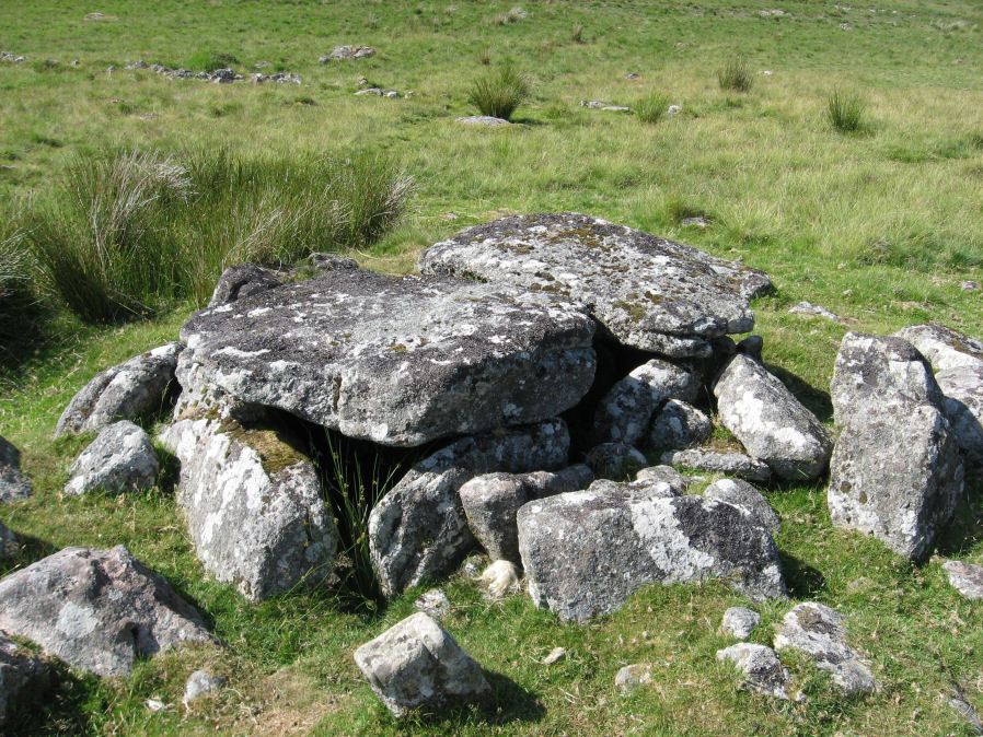
Table of Ritual and Burial Monuments on East Dart
The following table lists the records currently in this Guide Map. For an explantion of the Guide Maps and a table of all 62 Guide Maps, follow this link: Guide List Table. Introductory text will be added to each guide list in 2025. Notes on duplication and omissions will appear below the table once checks have been finalised.
Notes on possible duplications and omissions
Lade Hill Reported Cist: This feature needs confirming by fieldwork. If it exists it may warrant an HER entry.PS. These notes are to assist untangling complicated records and are neither permanent nor a criticism of the HER who do a fantastic job! The author finds it easier to systematically work through these records (2000+ of them) and add these notes, which are then to be communicated with the HER, if appropriate, it is a pragmatic way of dealing with lots of data without continually stopping and starting.
East Dart Guide Map
Guidance for walkers: The monuments featured in this database are archaeological treasures and need to be protected and preserved - please do not disturb any sites. Please check access and firing times before visiting sites, not all sites listed are on open access land. Firing ranges and boundaries of open access areas are marked on the OL28 OS Dartmoor Explorer map. Please stick to the country code and consider giving support to the numerous agencies that help to keep Dartmoor a fabulous natural and historic environment!
List of Ritual and Burial Monuments on East Dart
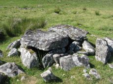
Roundy Park, Postbridge Cist
OS Map: SX 63920 79669
HER record: MDV5935
Megalithic Portal: 26041
PMD: Roundy Park
Alternate name: Roundy Park Cist
ShortName: CT Roundy Pk 1
Butler map: 27.4
Butler Vol 5: p.22 & Fig.3
DPD page: 113
Grinsell: LYD 40
Barrow Report: 21
Notes: One of the largest cists on Dartmoor. Discovered in August 1893 by Robert Burnard, who was responsible for the restoration of the grave. Lethbrdige diagram p.112, photo p.113. Butler Vol. 2. Map 27.4 (diagram of location p.41, diagram of site Vol. 5 p.22). Breton p.37
Nearby sites: SX63927967
Roundy Park, gate south of Reported Cist
OS Map: SX 63960 79480
HER record: MDV71274
ShortName: CT?Roundy Pk 2
Notes: Possible cist near a gate in the fence.
Nearby sites: SX63967948
Hartland Tor N Reported Cairn
OS Map: SX 64130 80830
HER record: MDV20488
ShortName: CN?Hartland N
Nearby sites: SX64138083
Hartland Tor W Reported Cairn
OS Map: SX 63950 79880
HER record: MDV20473
ShortName: CNxHartland W
Nearby sites: SX63957988
Chittaford Down Platform Cairn Circle
OS Map: SX 63502 79203
HER record: MDV5832
Megalithic Portal: 42726
PMD: Archerton
Alternate name: Chittaford Down 1 Platform Cairn Circle
ShortName: PC Chittaford1
Butler map: 27.18.1
Butler Vol 5: p.170 & Fig.109
Grinsell: LYD 38
Turner: E14
Notes: "Remains of a cairn, visible as a turf covered stony mound. The NE quadrant is robbed out but around the rest of the periphery are parts of a kerb of small boulders, some set on edge, giving a diameter of 6.5m NW-SE. Maximum height 0.6m in the SW quadrant, but elsewhere the interior is badly robbed." Butler says there is a possible end slab of a cist.
Nearby sites: SX63507920

Chittaford Down 2 Reported Cist
OS Map: SX 63531 79224
HER record: MDV19983
ShortName: CT?Chittaford2
Butler map: 27.18.2
Grinsell: LYD 38a
Notes: Reported by Prowse as cist 1891 - cist no longer visible
Nearby sites: SX63537922
Chittaford Down Platform Cairn Circle and Cist
OS Map: SX 63687 79463
HER record: MDV5932
Megalithic Portal: 52177
PMD: Chittaford Down
Alternate name: Chittaford Down 3 Platform Cairn Circle and Cist
ShortName: CT Chittaford3
Butler map: 27.18.3
Butler Vol 5: p.160 & Fig.100
DPD page: 112
Grinsell: LYD 39
Turner: E28
Barrow Report: 57
Notes: "A cist about 350 yards north of Archerton House. It has an irregular shape no coverstone and stands in the centre of a 14ft. diameter ruined cairn. There are traces of an enclosing ring of stones. Excavation in 1900 recovered wood charcoal and a worked flint flake from a small pit within the cist. Under the eastern side stone an archer's polished stone wrist guard was found". Lethbridge diagram and photo bottom p.112. Butler Chittaford Down 3 - Vol. 2. Map 27.18 (diagram Vol. 5. p.160).
Nearby sites: SX63697946
Braddon Lake 1 Cairn
OS Map: SX 63490 79624
HER record: MDV20242
ShortName: CN:Braddon 1
Nearby sites: SX63497962
Braddon Lake 2 Cairn
OS Map: SX 63600 79810
HER record: MDV52812
ShortName: CN:Braddon 2
Nearby sites: SX63607981

White Ridge S.W. Cairn
OS Map: SX 64149 81636
HER record: MDV6770
ShortName: CN WhiteRid SW
Butler map: 35.11
Grinsell: LYD 19
Notes: Round cairn lying immediately west of an enclosed stone hut circle settlement in Great Stannon newtake (SX64158160). Diameter 7.2 metres, height 0. 9 metres. Kerb. Robbed. Central pit 2.2 metres by 0.8 metres by 0.1 metres deep. Grass covered mound with some edge set stones on the west side which may represent the remnants of a kerb. The orientation of the central pit is 123 degrees. Large number of stones protruding from the mound, many of which have quartz in them.
Nearby sites: SX64158164
Broad Down N.E. Cairn
OS Map: SX 63731 81035
HER record: MDV6774
ShortName: CN BroadDn 1
Butler map: 35.13
Grinsell: LYD 18
Notes: HER: Cairn in north-east corcner of Broad Down visible as a stony turf-covered mound 6.5 metres by 6.3 metres with a maximum height of 0.8 metres with a central hollow
Nearby sites: SX63738104
Broad Down Cairn
OS Map: SX 63270 80070
HER record: MDV54679
ShortName: CN:BroadDn 2
Nearby sites: SX63278007
Broadun Ring Enclosed Settlement
OS Map: SX 63704 80192
HER record: MDV6746
Megalithic Portal: 26048
ShortName: ES BroadunRing
Notes: Breton p.38
Nearby sites: SX63708019
Broadun Enclosed Settlement
OS Map: SX 63540 79930
HER record: MDV5946
Megalithic Portal: 26043
ShortName: ES:Broadun
Notes: "An enclosed settlement, maximum dimensions 300m NE/SW by 250m NW/SE, giving an area of 6ha. Enclosure cut through on SE by a leat, but wall still visible. Inside are 36 huts, and a further 3 outside. Condition of huts mainly poor. Average internal diameter is 3.7m: the largest is 13m by 10.5m, the smallest 2.5m. The enclosure wall appears contemporary with or later than the huts. The interior of the enclosure appears to have been cleared." See also HER entry 6800
Nearby sites: SX63547993
Winney's Down Cairn
OS Map: SX 63620 81820
HER record: MDV59463
Alternate name: Winney's Down Cairn
ShortName: CN:Winneys 1
Nearby sites: SX63628182
Lade Hill Reported Cist
OS Map: SX 63340 81841
HER: No record found
PMD: Lade Hill
ShortName: CT?Lade Hill1
Notes: Via Radcliffe: "A good candidate for a damaged cist. There is one long slab still in situ which is orientated 120/300 degrees. Other stones are rather jumbled and some look shattered, so I believe at some time it must have received a hit or near miss from an artillery piece - there are quite a few old shell holes on this hillside." (Information from TAP Greeves). No NMR or HER records.
Nearby sites: SX63348184
Ringhill Stones Reported Stone Row
OS Map: SX 64730 79470
HER record: MDV5856
Megalithic Portal: 2101
ShortName: SRxRinghill
Notes: Breton p.34: Ringhill Stones stand in a field E. of the farm. The two large ones are 15ft. apart. The largest is nearly 5ft. high They were formerly part of stone rows which have been destroyed. 203 yds N.E. of the stones close to the Stannon Brook is the site of a blowing house; just beyond is a stone hedge, built into it is a mould stone.. HER: standing stones. Only two of the five standing stones could be found, it appears that the remainder were destroyed during the construction of an occupational road to Hartyland. These stones are of very weathered appearance, suggestive of great antiquity. See also entry on Megalithic Portal.
Nearby sites: SX64737947
Page last updated 10/12/24