
Guide to the Monuments on Crownhill
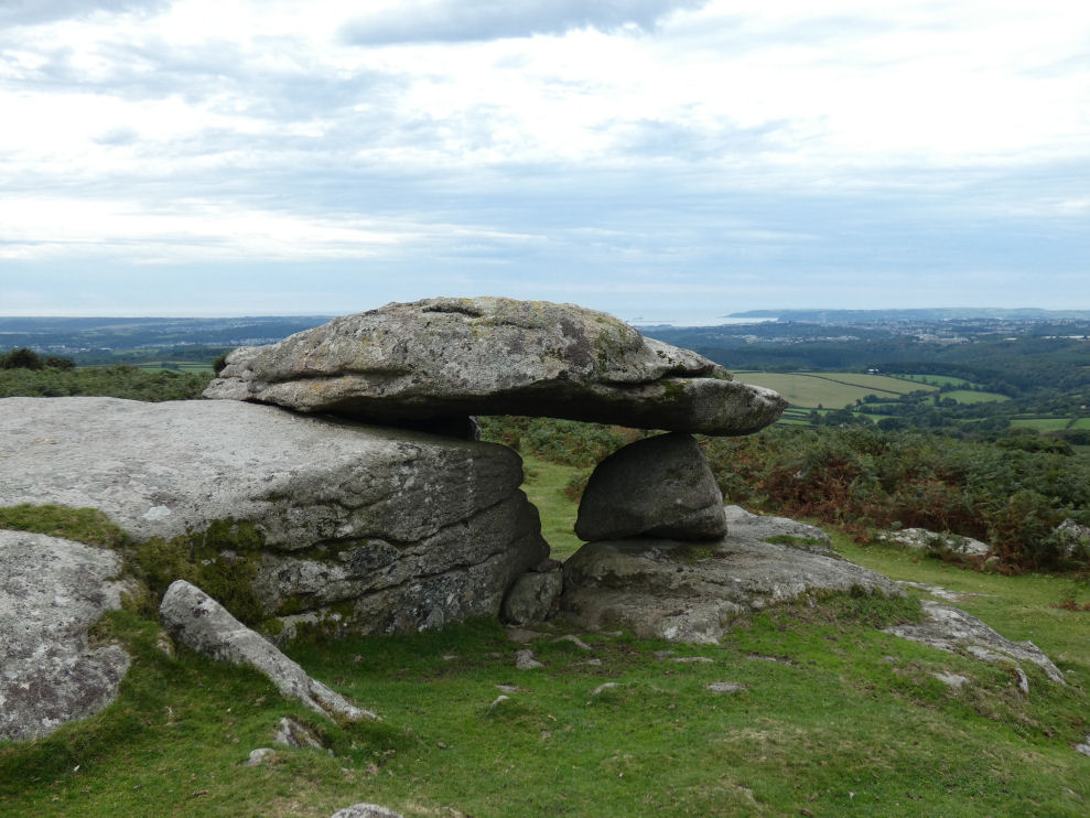
Table of Ritual and Burial Monuments on Crownhill
The following table lists the records currently in this Guide Map. For an explantion of the Guide Maps and a table of all 62 Guide Maps, follow this link: Guide List Table. Introductory text will be added to each guide list in 2025. Notes on duplication and omissions will appear below the table once checks have been finalised.
Notes on possible duplications and omissions
Crownhill Ridge S.2 and S.2: A minor typo: MDV132248 "Western of two mounds" SX 573 600 and MDV28078 "Eastern of two mounds" SX 574 600. The records are correct but both in the Butler section refer to Crownhill Ridge S. cairn '3' at SX57406001 of 4.0 metres diameter by 0.4 metres high. MDV132248 snould be Crownhill Ridge S. cairn '2' at SX57396001 of 3.0 metres diameter by 0.3 metres high.Wotter Common Reported Stone Circle: MDV130502 "Possible stone alignment to east of the two stone rows near Collard Tor". May or may not be suitable to amend this entry - there is a suggestion it could be a stone circle. The stone alignment being the northern section of the circle.
Heap of Stones: There are two HER entries for this feature (MDV12651 and MDV12652). Recommend deleting one or merging them.
PS. These notes are to assist untangling complicated records and are neither permanent nor a criticism of the HER who do a fantastic job! The author finds it easier to systematically work through these records (2000+ of them) and add these notes, which are then to be communicated with the HER, if appropriate, it is a pragmatic way of dealing with lots of data without continually stopping and starting.
Crownhill Guide Map
Guidance for walkers: The monuments featured in this database are archaeological treasures and need to be protected and preserved - please do not disturb any sites. Please check access and firing times before visiting sites, not all sites listed are on open access land. Firing ranges and boundaries of open access areas are marked on the OL28 OS Dartmoor Explorer map. Please stick to the country code and consider giving support to the numerous agencies that help to keep Dartmoor a fabulous natural and historic environment!
List of Ritual and Burial Monuments on Crownhill
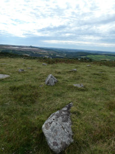
Wotter Common Reported Stone Circle
OS Map: SX 55872 62014
HER record: MDV130502
ShortName: SC:Wotter
Butler map: 48.6
Notes: Possible stone circle at Wotter reported by Sam Goodwin on a Facebook posting. The remains in this area are chaotic and disturbed by later interference. It is hard to make out the original stones of the nearby stone rows.
Nearby sites: SX55876201
Wotter Moor Cairn
OS Map: SX 55200 62200
HER record: MDV48885
ShortName: CN:Wotter Moor
Butler map: 48.
Notes: HER: 'Cairn ?' shown with a possible hut circle to the north on an eastern field boundary to the south of Hawks Tor within Shaugh Moor field system, see Figure 48.4 Volume 3.
Nearby sites: SX55206220
Collard Tor W. Stone Row
OS Map: SX 55833 62045
HER record: MDV2583
Megalithic Portal: 1843
The Stone Rows of GB: Collard Tor West
PMD: Collard Tor W Stone Row
Alternate name: Collard Tor W Stone Row
ShortName: SR CollardTorW
Butler map: 48.6.1
DPD page: 57
Notes: Butler Collard Tor 2. Described in entry for Collard Tor E. Lethbridge pp.55-7, diagram p.55.
Nearby sites: SX55836205
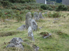
Collard Tor E. Stone Row
OS Map: SX 55849 62035
HER record: MDV14792
Megalithic Portal: 1842
The Stone Rows of GB: Collard Tor East
PMD: Collard Tor E Stone Row
Alternate name: Collard Tor E Stone Row
ShortName: SR CollardTorE
Butler map: 48.6.2
DPD page: 57
Notes: Butler Collard Tor 1. "Two stone rows each headed by a cairn lie on a gentle clitter-covered south-facing hillslope between 239m and 259m above OD. The rows which are oriented approximately north-south, diverge from their northern ends and are from 17m to 19 apart; a field bank interrupts the course of the east row.
Nearby sites: SX55856204
Collard Tor Encircled Cairn
OS Map: SX 55840 62030
HER record: MDV14793
Megalithic Portal: 794
PMD: Collard Tor
Alternate name: Collard Tor stone row 1 Encircled Cairn
ShortName: EC Collard Tor
Butler map: 48.6.1
DPD page: 57
Grinsell: SHA 46
Turner: F17
Barrow Report: 22
Notes: Cairn heading the easterly of the two Collard Tor rows. "The easterly cairn at SX 55846203 measures 8.1m. in diameter and 0.6m. high. The centre has been excavated, but apart from a large prone slab there is nothing to suggest a former cist. The mound is surrounded by a peristalith of boulders each of which is 0.9m. high and roughly 0.5m square. The row is similar to the other row and can be traced for 79.6m."
Nearby sites: SX55846203
Collard Tor stone row 2 Cairn
OS Map: SX 55820 62030
HER record: MDV2584
ShortName: CN Collard T3
Butler map: 48.6.2
Grinsell: SHA 45
Barrow Report: 22
Notes: HER: Cairn at the north end of the western stone row near Collard Tor
Nearby sites: SX55826203
Shaugh Prior 1 Reported Cairn
OS Map: SX 55700 60800
HER record: MDV2580
ShortName: CN?ShaughPri 1
Notes: No trace of the supposed ring cairn could be found. The reference falls within an area which has been cleared in advance of the construction of a mica dam.
Nearby sites: SX55706080
Shaugh Prior 2 Reported Cairn
OS Map: SX 54930 62130
HER record: MDV131445
ShortName: CNxShaughPri 2
Grinsell: A:SHA 1
Notes: Post-medieval boundary marker, An upright moorstone granite slab,thought by Rowe to be remains of Dolmen
Nearby sites: SX54936213
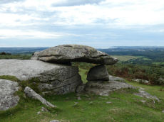
Hawk's Tor Rock Shelter
OS Map: SX 55348 62514
HER record: MDV2504
Megalithic Portal: 45856
PMD: Hawk's Tor - Possible Chambered Tomb
Alternate name: Hawk's Tor Rock Shelter
ShortName: RS HawksTor
DPD page: 56
Grinsell: A:SHA 2
Barrow Report: 60
Notes: Natural feature Hawk's Tor rock shelter - resembles tomb. "At the summit stands a rock shelter, v shaped in plan with a coverstone. Rowe referred to it as a cromlech. R. N. Worth called it a natural grouping of rocks. Mr. Beckerlegge on examining the coverstone, found a similar vein of quartz in the coverstone as in the rocks of the v shaped shelter, but running in a different direction. The coverstone must have been levered or swung in an anti-clockwise direction through an angle of 90 degrees to make a shelter of what was previously an opening between two vertical walls of rock". Might be prehistoric, could be from Roman period or later. Lethbridge p.54-6 Hawk's Tor Cromlech / Rock Shelter - diagram p.55, photo p.56. See also: The Modern Antiquarian.
Nearby sites: SX55356251
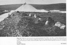
Cholwich Town Stone Row
OS Map: SX 58500 62300
HER record: MDV2438
Megalithic Portal: 1824
The Stone Rows of GB: Cholwichtown
PMD: Cholwich Town Stone Row
Alternate name: Cholwichtown stone row Stone Row
ShortName: SRxCholwich
Butler map: 48.7
Notes: "This ring and stone row is now covered by china clay waste. A stone row and circle on top of a low ridge, between Tory Brook and a tributary of the Yealm, near Cholwich Town. The row, extending over 700ft, consisted of uprights 2-3ft. high and 3ft. apart, the circle, at the northern end of the row, was 15ft. in diameter with seven upright stones. The site was excavated in 1961, and the sockets of many missing stones were found, also a pit 8ft. in diameter in the centre of the circle." Pollen analysis suggested the row was originally in a clearing of a wooded area.
Nearby sites: SX58506230
Cholwich Town (site of) Cairn Circle
OS Map: SX 58460 62250
HER record: MDV49508
Megalithic Portal: 770
PMD: Cholwich Town Stone Row
Alternate name: Cholwichtown stone row Cairn Circle
ShortName: CCxCholwich
Butler map: 48.
Grinsell: COR 5
Turner: G27
Notes: Site of former cairn circle. "the row, extending over 700ft, consisted of uprights 2-3ft. high and 3ft. apart, the circle, at the northern end of the row, was 15ft. in diameter with seven upright stones. The site was excavated in 1961, and the sockets of many missing stones were found, also a pit 8ft. in diameter in the centre of the circle. "
Nearby sites: SX58466225
Crownhill Tor Fields Reported Cairn
OS Map: SX 57360 60790
HER record: MDV12926
ShortName: CNxCrownTor
Butler map: 52.16.1
Notes: HER: Crownhill Tor Fields cairn at SX37366079 of 3.0 metres by 0.3 metres recorded at this location. However Figure 52.16 appears to show one hut circle to the north-west and two hut circles to the south-east of this feature within Enclosure 1.
Nearby sites: SX57366079
Crownhill Down Reported Cist
OS Map: SX 57000 60000
HER: No record found
ShortName: CT?CrownDown 1
Butler map: 52.16.6
Grinsell: SPA 8a
Notes: From a barrow 'destroyed many years since' came a large flint scraper and flint flakes PLYM Brent 1886. See. TDA 1886 Vol 18 p.74. Butler suggests that perhaps Brent's cairn was either 52.16.5 or 52.16.6.
"Crown Hill Down.—Amongst the rubbish and stones that had been removed and thrown down from a large circular barrow, that had been destroyed many years since, I found a large rude scraper of flint, and some broken pieces, all much weathered from exposure"
Nearby sites: SX57006000
Crownhill Down W.5 Cairn
OS Map: SX 56250 59810
HER record: MDV12658
ShortName: CN:CrownDown 2
Butler map: 52.16.5
Nearby sites: SX56255981
Crownhill Down W.6 Cairn
OS Map: SX 56790 59880
HER record: MDV12654
ShortName: CN:CrownDown 3
Butler map: 52.16.6
Grinsell: SHA 47
Notes: Cairn with hollow at centre found on sparkwell boundary.
Nearby sites: SX56795988
Crownhill Down W.6 (duplicate) Cairn
OS Map: SX 56860 60030
HER record: MDV20151
ShortName: CN:CrownDn Dup
Grinsell: SHA 47
Notes: Cairn with hollow at centre found on sparkwell boundary. This record originates with Grinsell. It seems very likely this is Butler 52.16.6. The grid references are a little different but the size and description of being on the Sparkwell boundary are the same. Butler does not link his record to SHAUGH PRIOR 47 but he doesn't link any record to that Grinsell record. Both locations are now underneath workings. There are separate HER entries for the Butler (MDV12654) and Grinsell (MDV20151). We will treat this one as a duplicate.
Nearby sites: SX56866003
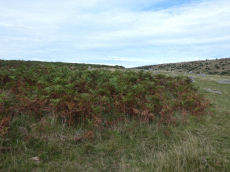
Crownhill Ridge (c.13) Cairnfield Master
OS Map: SX 57100 59800
HER record: MDV1780
ShortName: CN:Crownhill M
Notes: HER: Barrow cemetery on the ridge of Crownhill Down with 13 cairns of various shapes with diameters from 3.0 metres to at least 13.0 metres and heights from 0.1 to 0.7 metres.
Nearby sites: SX57105980
Crownhill Ridge 1 Cairn
OS Map: SX 57230 59730
HER record: MDV1788
ShortName: CN:Crownhill 1
Butler map: 52.16.7.1
Grinsell: SPA 7
Notes: HER: Barrow 'I' is one of thirteen in the cemetery on the ridge of Crownhill Down. No evidence of the barrow was noted on aerial photographs or lidar derived images.
Nearby sites: SX57235973
Crownhill Ridge 2 Cairn
OS Map: SX 57230 59750
HER record: MDV1787
ShortName: CN:Crownhill 2
Butler map: 52.16.7.2
Grinsell: SPA 6
Notes: HER: Barrow 'H' is one of thirteen in the cemetery on the ridge of Crownhill Down of 9.0 metres diameter by 0.4 metres high. The barrow is visible on aerial photographs.
Nearby sites: SX57235975
Crownhill Ridge 3 Cairn
OS Map: SX 57235 59778
HER record: MDV1786
ShortName: CN:Crownhill 3
Butler map: 52.16.7.3
Grinsell: SPA 5
Notes: HER: Barrow 'G' is one of thirteen in the cemetery on the ridge of Crownhill Down of 12.0 metres diameter by 0.3 metres high. The barrow is visible on aerial photographs
Nearby sites: SX57245978
Crownhill Ridge 4 Cairn
OS Map: SX 57200 59780
HER record: MDV1785
ShortName: CN:Crownhill 4
Butler map: 52.16.7.4
Grinsell: SPA 4
Notes: HER: Barrow 'F' is one of thirteen in the cemetery on the ridge of Crownhill Down of 13.0 metres diameter by 0.7 metres high. This is the only barrow in the group shown on historic maps. The barrow is still visible on aerial photographs
Nearby sites: SX57205978
Crownhill Ridge 5 Cairn
OS Map: SX 57190 59810
HER record: MDV1784
ShortName: CN:Crownhill 5
Butler map: 52.16.7.5
Grinsell: SPA 3
Notes: HER: Barrow 'E' is one of thirteen in the cemetery on the ridge of Crownhill Down of 8.0 metres diameter by 0.2 metres high. The barrow is visible on aerial photographs
Nearby sites: SX57195981
Crownhill Ridge 6 Cairn
OS Map: SX 57190 59830
HER record: MDV1783
ShortName: CN:Crownhill 6
Butler map: 52.16.7.6
Grinsell: SPA 2a
Notes: HER: Barrow 'D 'is one of thirteen in the cemetery on the ridge of Crownhill Down of 8.0 metres diameter by 0.2 metres high. The earthworks are visible on aerial photographs
Nearby sites: SX57195983
Crownhill Ridge 7 Cairn
OS Map: SX 57180 59850
HER record: MDV1782
ShortName: CN:Crownhill 7
Butler map: 52.16.7.7
Grinsell: SPA 2
Notes: HER: Barrow 'C' is one of thirteen in the cemetery on the ridge of Crownhill Down of 7.0 to 8.0 metres diameter by 0.2 metres high. The earthworks consist of two conjoined mounds divided by a later robber pit. The earthworks remain identifiable on aerial photographs
Nearby sites: SX57185985
Crownhill Ridge 8 Cairn
OS Map: SX 57180 59870
HER record: MDV1781
ShortName: CN:Crownhill 8
Butler map: 52.16.7.8
Grinsell: SPA 1a
Notes: HER: Barrow 'B' is one of thirteen in the cemetery on the ridge of Crownhill Down of 8.0 metres diameter by 0.4 metres high
Nearby sites: SX57185987
Crownhill Ridge 9 Cairn
OS Map: SX 57170 59930
HER record: MDV11801
ShortName: CN:Crownhill 9
Butler map: 52.16.7.9
Grinsell: SPA 1
Notes: HER: Barrow 'A' is one of thirteen in the cemetery on the ridge of Crownhill Down of 9.0 metres diameter by 0.2 metres high
Nearby sites: SX57175993
Crownhill Ridge 10 Cairn
OS Map: SX 57170 59960
HER record: MDV76030
ShortName: CN:Crownhill10
Butler map: 52.16.7.10
Notes: HER: Barrow 'J' is one of thirteen in the cemetery on the ridge of Crownhill Down of 9.0 metres diameter by 0.3 metres high.The barrow is visible on aerial photographs
Nearby sites: SX57175996
Crownhill Ridge 11 Cairn
OS Map: SX 57180 60000
HER record: MDV12699
ShortName: CN:Crownhill11
Butler map: 52.16.7.11
Notes: HER: Barrow 'K' is one of thirteen in the cemetery on the ridge of Crownhill Down of 7.0 metres diameter by 0.1 metres high. Not visible on aerial photographs
Nearby sites: SX57186000
Crownhill Ridge 12 Cairn
OS Map: SX 57160 60000
HER record: MDV12787
ShortName: CN:Crownhill12
Butler map: 52.16.7.12
Notes: HER: Barrow 'L' is one of thirteen in the cemetery on the ridge of Crownhill Down of 5.0 metres diameter by 0.1 metres high
Nearby sites: SX57166000
Crownhill Ridge 13 Cairn
OS Map: SX 57160 60040
HER record: MDV12939
ShortName: CN:Crownhill13
Butler map: 52.16.7.13
Notes: HER: Barrow 'M' is one of thirteen in the cemetery on the ridge of Crownhill Down of 3.5 metres diameter by 0.2 metres high
Nearby sites: SX57166004
Hawkesborough Cairn
OS Map: SX 57240 59520
HER record: MDV1802
ShortName: CN:Hawkesbor1
Butler map: 52.16.8
Grinsell: SPA 8
Notes: HER: The monument includes a round cairn situated on the southern summit of the prominent ridge called Crownhill Down. The round cairn survives as a circular stony mound measuring up to 15 metres in diameter and 1.4 etresm high. In the centre is a large hollow indicating early partial excavation or robbing. This cairn is known locally as ‘Hawkesborough’ and was mentioned in a lease dated 16th November 1562 as tin bound for a nearby tinworks. It is probably an outlying cairn associated with the nearby round cairn cemetery on Crownhill Down which is the subject of a separate scheduling.
Nearby sites: SX57245952
Crownhill Ridge S.1 Cairn
OS Map: SX 57400 60040
HER record: MDV2554
ShortName: CN:CrownhillS1
Butler map: 52.16.9.1
Notes: HER: Crownhill Ridge S. cairn '1' at SX57406004 of 19.0 metres diameter by 1.2 metres high. A huge structure with a central pit and just escaping the waste heap encroachment at the western limit of Headon clayworks. It overlooks a pair of small cairns at its foot.
Nearby sites: SX57406004
Crownhill Ridge S.2 Cairn
OS Map: SX 57390 60010
HER record: MDV132248
ShortName: CN:CrownhillS2
Butler map: 52.16.9.2
Notes: HER: Crownhill Ridge S. cairn '2' at SX57396001 of 4.0 metres diameter by 0.4 metres high. The western cairn at the foot of the larger cairn to the north.
Nearby sites: SX57396001
Crownhill Ridge S.3 Cairn
OS Map: SX 57400 60010
HER record: MDV28078
ShortName: CN:CrownhillS3
Butler map: 52.16.9.3
Notes: HER: Crownhill Ridge S. cairn '3' at SX57406001 of 4.0 metres diameter by 0.4 metres high. The eastern cairn at the foot of the larger cairn to the north.
Nearby sites: SX57406001
Crownhill Summit Cairn
OS Map: SX 57480 60250
HER record: MDV12912
ShortName: CN:CrownSum
Butler map: 52.16.10
Notes: HER: Crownhill Summit carn at SX57486025 of 6.0 metres diameter by 0.7 metres high. It has been dug into on one side and surrounded by an outer ring of blocks, two only remaining in place. This cairn was the focus of a pair of reaves originating on the nearby field system.
Nearby sites: SX57486025
Ridding Down 1 Cairn
OS Map: SX 58043 61208
HER record: MDV2560
ShortName: CN:RiddingDn 1
Butler map: 52.16.11
Grinsell: COR 7
Notes: HER: Round barrow on Ridding Down of 8.0 metres diameter by 0.6 metres high. An earthwork mound is clearly visible on aerial photographs of the 1960s. The mound has been mutilated by historic robbing, visible as a central pit. The mound is adjacent to and possibly respected by a boundary bank, probably the remains of a reave.
Nearby sites: SX58046121
Ridding Down 2 Cairn
OS Map: SX 58045 61359
HER record: MDV2518
ShortName: CN:RiddingDn 2
Butler map: 52.16.12
Grinsell: COR 6
Notes: HER: Ring barrow on Ridding Down of 20.0 metres diameter by 0.5 metres high. A low mound encircled by a narrow scarp and outer bank are clearly visible on aerial photographs. It is one of a pair of prehistoric round barrows recorded on Ridding Down.
Nearby sites: SX58056136
Heap of Stones Reported Cairn
OS Map: SX 58600 59720
HER record: MDV12651
ShortName: CN?HeapStones
Notes: Destroyed
Nearby sites: SX58605972
Heap of Stones (duplicate) Reported Cairn
OS Map: SX 58600 59720
HER record: MDV12652
ShortName: CN?HeapStonDup
Notes: Destroyed
Nearby sites: SX58605972
Boringdon Camp Fort
OS Map: SX 54419 59637
HER record: MDV1751
Megalithic Portal: 7752
ShortName: FT:Boringdon
Nearby sites: SX54425964
Headon Down Cairn Circle
OS Map: SX 58600 59700
HER record: MDV12650
ShortName: CC:HeadonDown
Notes: HER: A ring cairn close to the summit of Headon Down. The cairn was not visible as an earthwork on aerial photographs or lidar derived images and has probably been destroyed by quarrying activity.
Nearby sites: SX58605970
Crownhill Down Cairn
OS Map: SX 57300 60000
HER record: MDV35820
ShortName: CN:Crownhill
Notes: HER: Cairn on Crownhill Down of 5.0 metres diameter by 0.5 metres high with a hollow centre. Visible as low rise and by change in vegetation, which is grassier above it.
Nearby sites: SX57306000
Page last updated 10/12/24