
Prehistoric sites within 5km of SX 82991 75194
Guidance for walkers: The monuments featured in this database are archaeological treasures and need to be protected and preserved - please do not disturb any sites. Please check access and firing times before visiting sites, not all sites listed are on open access land. Firing ranges and boundaries of open access areas are marked on the OL28 OS Dartmoor Explorer map. Please stick to the country code and consider giving support to the numerous agencies that help to keep Dartmoor a fabulous natural and historic environment!
About the database listings: In all listings clicking on the photo or the site name will open a page for the site with a larger photo and further details from the database. The database now has over 6680 records covering nearly all publicly listed sites on Dartmoor including around 4800 round houses. This level of detail is of interest to archaeologists but tends to swamp listings of sites more likely to be of interest for walkers. For this reason, the listings default to around 550 core sites only. These are the stone circles, stone rows and the ring cairns listed by Turner. The default search radius is 2 km. The controls below the map can be used to start a new search by entering a 6- or 8-digit reference (without the prefix "SX"). The search radius can be specified and you can add incremental Display layers of detail on top of the core sites. If using a more detailed layer you will need to decrease the search radius to avoid getting hundreds of search results.
- Core sites Default listing of core sites consisting of stone circles & rows and some of the major ring cairns.
- Plus cairns adds approx. 1000 cairns and other minor sites not included in the core listings but excluding round houses.
- Plus round houses adds approx. 4800 round houses.
- Plus non-sites adds in the records for sites that no longer exist or are not prehistoric sites.
- Plus duplicates adds records excluded as duplicates. Those maybe duplicate records in external listings (e.g. the Historic Environment Records). For example, some sites have been identified as cairns in some listings and interpreted as round houses in other listings and both records appear.
These listings have incorporated, matched up and merged all of the records from all of the major archaeological listings including: Worth, Grinsell, Turner, Butler, Bill Radcliffe, Sandy Gerrard, Megalithic Portal, the National Monument Records and the Historic Environment Records. The author would like to thank Bill, Sandy, the lovely people both at Megalithic Portal (especially Anne Tate who did an amazing job to link listings) and at ACE Archaeology for collaborative work over the years to synchronise and correct listings across the various websites which now interlink. A culmination of years of work the final merger of cairn records took 3 months of cross referencing in 2017 the result being a snapshot of the records at that time. This data has in turn been refined since by field work and research. The round house data was supplied by Sandy Gerrard. Grid references are in order of accuracy: from Google Earth satellite, if visible and found, from a Garmin GPS reading, if visited by the author and from the literature otherwise. Individual site pages will state the source of the grid reference and provide satellite imagery. If a site listing lacks a photo it has not yet been visited by the author in which case the grid reference is from the literature.
Currently the database only includes sites which can be represented by a grid reference. Reaves are not included as they require GIS shape technology which is beyond the current capability of this system. To see the sources for the records, look at the tables on the resources menu. The database listings can also be viewed on a Google map and downloaded as GPS datasets for Garmin devices.
Corrections, or any feedback or suggestions are very welcome, email: info@dartmoorwalks.org.uk.
NOTE: Clicking on the icons for each monument in the map will give the name of the site. You can zoom in and out and drag the map around.
List of sites within 5km of SX 82991 75194
Berrys Wood Fort
Prehistoric Dartmoor Walks: Dartmoor Resource: Table of Devon Iron Age Forts
OS Map: SX 84670 71061
HER: MDV9145
Megalithic Portal: 7763
ShortName: FT:Berrys Wood
Nearby sites: SX 84670 71061
Distance: 4.46km
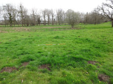
Parke 1 Reported Cairn
OS Map: SX 80945 78436
HER: MDV122315
ShortName: CN-Parke 1
Notes: "The circular ditched crop mark sits at the end of a natural grassy promontory that appears to be surrounded by two linear earthworks, giving it a view over the marshes to the north-east. The grid reference is 809784. From the measurements, it appears that it is almost a perfect circle. The ditch is unbroken."
"Measurements
North to South (From outer edges of the crop mark ring) - 7 metres 50 cm
North to South (From inner edges of the crop mark ring) - 4 metres 70 cm
East to West (From outer edges of crop mark ring) - 7 metres 80 cm
East to West (From inner edges of crop mark ring) - c.5 metres"
Photo by Jowan Albon. Reproduced with permission, copyright remains with Jowan Albon.
Nearby sites: SX 80945 78436
Distance: 3.83km
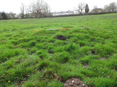
Parke 2 Reported Cairn
OS Map: SX 81007 78329
HER: MDV122310
ShortName: CN-Parke 2
Notes: "Low grassy mound, with a slight ring apparent, it is about half a meter high and sits on the edge of a slight marshy area in a field dominated by an oak tree. It sits in the field behind the Bovey Tracey Fire station, located to the right side of the main path."
"Measurements
North to South (Including ring, there appears to be a slight ring around it not apparent in photos), 5 metres 80 cm
North to South (W/o ring) - 3 metres 20cm
East to West (Including ring) 6 metres 60cm
East to West (W/o ring) 4 metres 40cm"
Photo by Jowan Albon. Reproduced with permission, copyright remains with Jowan Albon.
Nearby sites: SX 81007 78329
Distance: 3.71km