
Prehistoric sites within 2km of SX 57880 74220
Guidance for walkers: The monuments featured in this database are archaeological treasures and need to be protected and preserved - please do not disturb any sites. Please check access and firing times before visiting sites, not all sites listed are on open access land. Firing ranges and boundaries of open access areas are marked on the OL28 OS Dartmoor Explorer map. Please stick to the country code and consider giving support to the numerous agencies that help to keep Dartmoor a fabulous natural and historic environment!
About the database listings: In all listings clicking on the photo or the site name will open a page for the site with a larger photo and further details from the database. The database now has over 6680 records covering nearly all publicly listed sites on Dartmoor including around 4800 round houses. This level of detail is of interest to archaeologists but tends to swamp listings of sites more likely to be of interest for walkers. For this reason, the listings default to around 550 core sites only. These are the stone circles, stone rows and the ring cairns listed by Turner. The default search radius is 2 km. The controls below the map can be used to start a new search by entering a 6- or 8-digit reference (without the prefix "SX"). The search radius can be specified and you can add incremental Display layers of detail on top of the core sites. If using a more detailed layer you will need to decrease the search radius to avoid getting hundreds of search results.
- Core sites Default listing of core sites consisting of stone circles & rows and some of the major ring cairns.
- Plus cairns adds approx. 1000 cairns and other minor sites not included in the core listings but excluding round houses.
- Plus round houses adds approx. 4800 round houses.
- Plus non-sites adds in the records for sites that no longer exist or are not prehistoric sites.
- Plus duplicates adds records excluded as duplicates. Those maybe duplicate records in external listings (e.g. the Historic Environment Records). For example, some sites have been identified as cairns in some listings and interpreted as round houses in other listings and both records appear.
These listings have incorporated, matched up and merged all of the records from all of the major archaeological listings including: Worth, Grinsell, Turner, Butler, Bill Radcliffe, Sandy Gerrard, Megalithic Portal, the National Monument Records and the Historic Environment Records. The author would like to thank Bill, Sandy, the lovely people both at Megalithic Portal (especially Anne Tate who did an amazing job to link listings) and at ACE Archaeology for collaborative work over the years to synchronise and correct listings across the various websites which now interlink. A culmination of years of work the final merger of cairn records took 3 months of cross referencing in 2017 the result being a snapshot of the records at that time. This data has in turn been refined since by field work and research. The round house data was supplied by Sandy Gerrard. Grid references are in order of accuracy: from Google Earth satellite, if visible and found, from a Garmin GPS reading, if visited by the author and from the literature otherwise. Individual site pages will state the source of the grid reference and provide satellite imagery. If a site listing lacks a photo it has not yet been visited by the author in which case the grid reference is from the literature.
Currently the database only includes sites which can be represented by a grid reference. Reaves are not included as they require GIS shape technology which is beyond the current capability of this system. To see the sources for the records, look at the tables on the resources menu. The database listings can also be viewed on a Google map and downloaded as GPS datasets for Garmin devices.
Corrections, or any feedback or suggestions are very welcome, email: info@dartmoorwalks.org.uk.
NOTE: Clicking on the icons for each monument in the map will give the name of the site. You can zoom in and out and drag the map around.
List of sites within 2km of SX 57880 74220
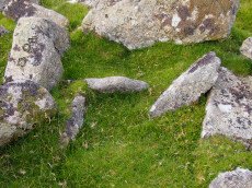
Devil's Elbow Platform Cairn Circle
OS Map: SX 58192 72708
HER: MDV14310
Megalithic Portal: 36761
PMD: Devil's Bridge
Alternate name: Hart Tor N. Platform Cairn Circle
ShortName: PC:DevilsElbow
Butler map: 46.1
Butler Vol 5: p.168 & Fig.107
Grinsell: WAL 10
Turner: E5
Notes: Ring cairn consisting of a circle of close set stones: almost a kerb circle, interior flat and no sign of cist. Diameter 8m, height 0.3m. HER: Ring cairn to the north-east of the settlement to the north of Hart Tor recorded in the 19th century as containing a 'dilapidated kistvaen'
Nearby sites: SX 58192 72708
Distance: 1.54km
Hart Tor N. Settlement
OS Map: SX 5816 7243
HER: MDV3791
Megalithic Portal: 36762
ShortName: ST:HartTorN
Nearby sites: SX 5816 7243
Distance: 1.81km
Holmingbeam Cup Stone
OS Map: SX 59488 75233
HER: MDV12807
Megalithic Portal: 10606
ShortName: CS Holmingbeam
DPD page: 107
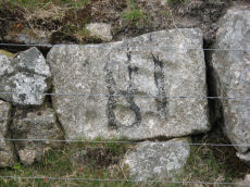
Notes: "Mortar stone of uncertain date incorporated into the eastern boundary wall of Long Plantation. It was formerly, erroneously, recorded as a cup-marked stone." The stone is upside down in wall by road side and has the figure 18 painted on it. Lethbridge diagram and photo p.107
Nearby sites: SX 59488 75233
Distance: 1.90km

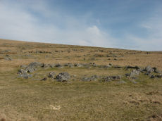
Mis Tor Farm Embanked Cairn Circle
OS Map: SX 56927 75953
HER: MDV15372
Megalithic Portal: 45609
Alternate name: Little Mis Tor S.E. Embanked Cairn Circle
ShortName: CC:MisTor Farm
Butler map: 30.17
Butler Vol 5: p.163 & Fig.104
Grinsell: LYD 37a
Turner: B13
Notes: HER Base of ancient tumulus, about 20m in diameter, may have formed a bound of the ancient boundary between Lydford and Walkhampton (Prowse). Butler: Little Mis Tor SE cairn at SX56927595 of 22.0 metres diameter by 0.4 metres high. This large but low cairn has suffered some trenching around the eastern side. An outer bank 22 metres across surrounds a level interior rising to a small mound at the centre on which are lying several small stones. The few slabs visible within the bank show that it was built with inner and outer faces around a rubble core.
Nearby sites: SX 56927 75953
Distance: 1.98km
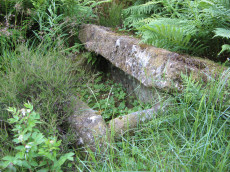
Thornworthy 2 Cist
OS Map: SX 59015 73471
HER: MDV6613
Megalithic Portal: 15453
PMD: Thornworthy
ShortName: CT Thornworth
Butler map: 35.22
Butler Vol 5: p.64 & Fig.42
DPD page: 137
Grinsell: CHA 3
Turner: E39
Barrow Report: 56
Notes: Located at the High Moorland Visitor Centre at Princetown. There were two cists at Thornworthy and both were excavated. This record refers to the second slightly smaller cist. This was removed after the excavation and given to the care of William Pengelly (see account 1880) of the Torquay Natural History Society and re-erected at Torquay Museum. The cist is now located in the Jack Wigmore Garden (also known as the Dartmoor Conservation Garden). It can be accessed by walking a very short distance down from the mini roundabout outside the centre down the Yelverton Road (Plymouth Hill). A gate on the right hand side behind the visitors centre gives access to the garden. See also: Thornworthy Cist. Butler Vol. 2. Map 35.22 p.169, see also diagram Vol. 5. p.64.
Nearby sites: SX 59015 73471
Distance: 1.36km
Walkhampton Enclosed Settlement
Prehistoric Dartmoor Walks: Dartmoor Site: Walkhampton and Yes Tor Bottom Settlements
OS Map: SX 56772 72867
HER: MDV4964
Megalithic Portal: 45325
ShortName: ES Walkhampton
Notes: "Hut circles 550m s of foggintor quarries. A very fine settlement, set within a well built and substantial enclosure wall, enclosing an area of some 1.0ha. Five hut circles occur within the enclosure varying between 6-10m in diam ... Outside the enclosure to the w are five further huts of similar dimensions - again one of these shows sign of alteration. Under moorland grass." The site was excavated in 1897 by Burnard and Baring-Gould.
Nearby sites: SX 56772 72867
Distance: 1.75km
Yellowmeade Farm Cist
OS Map: SX 56350 74465
HER: MDV5002
Megalithic Portal: 45778
PMD: Yellowmeade Farm NW.
Alternate name: Yellowmeade 1 Cist
ShortName: CT Yellowm Fm1
Butler map: 44.1.1
DPD page: 18
Grinsell: WAL 7
Barrow Report: 67
Notes: Butler Yellowmeade 1 - Vol. 3. Map 44.1 (diagram p.17).
Nearby sites: SX 56350 74465
Distance: 1.55km