
Prehistoric sites within 2km of SX 67730 63490
Guidance for walkers: The monuments featured in this database are archaeological treasures and need to be protected and preserved - please do not disturb any sites. Please check access and firing times before visiting sites, not all sites listed are on open access land. Firing ranges and boundaries of open access areas are marked on the OL28 OS Dartmoor Explorer map. Please stick to the country code and consider giving support to the numerous agencies that help to keep Dartmoor a fabulous natural and historic environment!
About the database listings: In all listings clicking on the photo or the site name will open a page for the site with a larger photo and further details from the database. The database now has over 6680 records covering nearly all publicly listed sites on Dartmoor including around 4800 round houses. This level of detail is of interest to archaeologists but tends to swamp listings of sites more likely to be of interest for walkers. For this reason, the listings default to around 550 core sites only. These are the stone circles, stone rows and the ring cairns listed by Turner. The default search radius is 2 km. The controls below the map can be used to start a new search by entering a 6- or 8-digit reference (without the prefix "SX"). The search radius can be specified and you can add incremental Display layers of detail on top of the core sites. If using a more detailed layer you will need to decrease the search radius to avoid getting hundreds of search results.
- Core sites Default listing of core sites consisting of stone circles & rows and some of the major ring cairns.
- Plus cairns adds approx. 1000 cairns and other minor sites not included in the core listings but excluding round houses.
- Plus round houses adds approx. 4800 round houses.
- Plus non-sites adds in the records for sites that no longer exist or are not prehistoric sites.
- Plus duplicates adds records excluded as duplicates. Those maybe duplicate records in external listings (e.g. the Historic Environment Records). For example, some sites have been identified as cairns in some listings and interpreted as round houses in other listings and both records appear.
These listings have incorporated, matched up and merged all of the records from all of the major archaeological listings including: Worth, Grinsell, Turner, Butler, Bill Radcliffe, Sandy Gerrard, Megalithic Portal, the National Monument Records and the Historic Environment Records. The author would like to thank Bill, Sandy, the lovely people both at Megalithic Portal (especially Anne Tate who did an amazing job to link listings) and at ACE Archaeology for collaborative work over the years to synchronise and correct listings across the various websites which now interlink. A culmination of years of work the final merger of cairn records took 3 months of cross referencing in 2017 the result being a snapshot of the records at that time. This data has in turn been refined since by field work and research. The round house data was supplied by Sandy Gerrard. Grid references are in order of accuracy: from Google Earth satellite, if visible and found, from a Garmin GPS reading, if visited by the author and from the literature otherwise. Individual site pages will state the source of the grid reference and provide satellite imagery. If a site listing lacks a photo it has not yet been visited by the author in which case the grid reference is from the literature.
Currently the database only includes sites which can be represented by a grid reference. Reaves are not included as they require GIS shape technology which is beyond the current capability of this system. To see the sources for the records, look at the tables on the resources menu. The database listings can also be viewed on a Google map and downloaded as GPS datasets for Garmin devices.
Corrections, or any feedback or suggestions are very welcome, email: info@dartmoorwalks.org.uk.
NOTE: Clicking on the icons for each monument in the map will give the name of the site. You can zoom in and out and drag the map around.
List of sites within 2km of SX 67730 63490
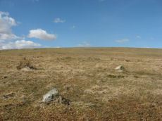
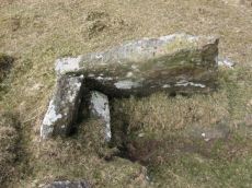
Black Tor (Avon) Stone Row
OS Map: SX 67730 63494
HER: MDV28589
Megalithic Portal: 1772
The Stone Rows of GB: Black Tor Avon Stone Row
PMD: Black Tor Avon Stone Row
ShortName: SR BlackTor 1
Butler map: 57.25
DPD page: 85
Notes: "A stone row running north west - south east seen on the plateau west of Black Tor". The stones are very hidden and difficult to see. The row is headed at the NW end by two small cairns. Lethbridge suggests remains of cist in one of them, diagram p.85. See also HER 5752, SX 66 SE 89 and SX 66 SE 33. NB. There is also a possible second row about 200 metres away SiteID=1320
Nearby sites: SX 67730 63494
Distance: 0.00km
Brent Moor House Cist
OS Map: SX 6802 6403
HER: MDV5744
Megalithic Portal: 45754
PMD: Brent Moor House
ShortName: CT:Brent Moor
Grinsell: BRE 3
Barrow Report: 65 66
Notes: "A cist lies on the right bank of the Avon, a short distance above Brent Moor House, about 175 feet below the small stream which flows south of Riders Rings ... The cist, which consists of two end stones and one side stone, stands in a small cairn." Doubtful. (grinsell) "supposed cairn of large stones, enclosing possible cist placed se-nw. The whole area is covered with clitter, and it is possible that the site may be natural. In summer it is under dense bracken. No measurements given." Butler Vol. 4. Map 57.9 (not actually covered in Butler but relevant map). " A Medieval or later tinner's cache situated opposite Woolholes on the west bank of the River Avon. Considered under the Monument Protection Programme by previous Monument Protection Programme Advisor who did not recommend it for scheduling."
Nearby sites: SX 6802 6403
Distance: 0.61km
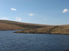
Dean Moor Enclosed Settlement
OS Map: SX 67741 65458
HER: MDV14799
Megalithic Portal: 45324
ShortName: ES Dean Moor
Notes: Enclosed settlement on Dean Moor, excavated between 1954 and 1956, prior to construction of the reservoir. Prehistoric walled enclosure containing at least 13 huts together with pens. Parallels have been drawn with the settlement at Kestor. Part of the prehistoric settlement was incorporated into a medieval farmstead (see HER record 14221). Part of site now flooded by Avon Reservoir.
Nearby sites: SX 67741 65458
Distance: 1.97km
Gripper's Hill Enclosed Settlement
OS Map: SX 68156 64874
HER: MDV5742
Megalithic Portal: 45320
Alternate name: Gripper's Hill Enclosed Settlement
ShortName: ES Grippers
Notes: "A Bronze Age pastoral settlement on Gripper's Hill, Dean Prior, was excavated in July 1954 by Lady Aileen Fox on behalf of the Ministry of Works. The site comprises four enclosures containing ten or more huts."
Nearby sites: SX 68156 64874
Distance: 1.45km
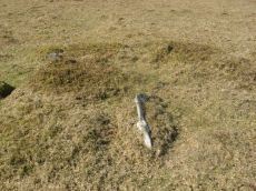
Hickley Ridge Central Cist
OS Map: SX 67224 62250
HER: MDV61772
Megalithic Portal: 45810
PMD: Hickley Ridge Central
Alternate name: Hickley Ridge 2 Cist
ShortName: CT HickleyCe
Butler map: 56.14.3
Butler Vol 5: p.175 & Fig.117
DPD page: 84
Notes: Butler Hickley Ridge Cairn and Cist 2. 56.14.3 diagram Vol 5 p.175. "Two slabs, possibly of a cist, embedded in low mound south of the leat on Hickley Ridge." Lethbridge diagram p.84, photo bottom left.
Nearby sites: SX 67224 62250
Distance: 1.34km
Hickley Ridge E Cist
OS Map: SX 67402 62381
HER: MDV61773
Megalithic Portal: 45811
PMD: Hickley Ridge E.
Alternate name: Hickley Ridge 1 Cist
ShortName: CT HickleyE
Butler map: 56.14.2
Butler Vol 5: p.175 & Fig.116
DPD page: 84
Notes: Butler Hickley Ridge Cist 1. 56.14.3 diagram Vol 5 p.175. "One side and one end slab of cist on Hickley Ridge, with other fallen stones in the mound. One of three badly damaged cists aligned south-west to north-east across Hickley Ridge, recognised by Butler in 1995." Lethbridge diagram and photo on right of p.84.
Nearby sites: SX 67402 62381
Distance: 1.16km
Hickley Ridge W Cist
OS Map: SX 6659 6203
HER: MDV13283
Megalithic Portal: 45809
PMD: Hickley Ridge W.
Alternate name: Hickley Ridge 3 Cist
ShortName: CT:HickleyW
Butler map: 56.14.4
Butler Vol 5: p.176 & Fig.118
DPD page: 84
Notes: "Cairn and cist on the East side of Brent Fore Hill. The cairn is 6.0m in diameter, merging into the slope of the hill and being about 0.5m high on the downslope side, which has a retaining kerb. There is a central cist of which two parallel slabs remain set on edge at the NW and SE sides. An upright stone 0.9m high is offset from the cist on the NW side." Lethbridge p.84 diagram and photo top left. Butler Hickley Ridge 3 56.14.4 diagram Vol 5 p.176.
Nearby sites: SX 6659 6203
Distance: 1.85km
Knatta Barrow Stone Ring Cairn Circle
OS Map: SX 65970 64212
HER: MDV5717
Megalithic Portal: 45842
ShortName: RC:Knatta Bar
Butler map: 57.29
Butler Vol 5: p.160 & Fig.102
Grinsell: BRE 2
Turner: A54
Notes: "This large cairn (24m diameter, 1.7m height) composed of loose granite boulders. It is unusual among summit cairns in having a well defined outer bank about 1m wide and 0.5m high. This is partly turf covered but where eroded can be seen to be built of loose stone like the central cairn which touches it. It shows best on the north and east sides, while on the south west side it tends to merge into the body of the cairn."
Nearby sites: SX 65970 64212
Distance: 1.90km
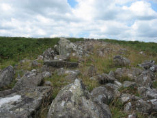
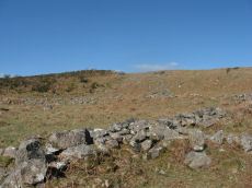
Riders Rings Enclosed Settlement
OS Map: SX 67870 64359
HER: MDV5767
Megalithic Portal: 45321
ShortName: ES RidersRings
DPD page: 85
Notes: "The largest and most important pound in the Avon Valley. Situated on the eastern slope of Zeal Plains. It is best regarded as being two contiguous pounds, of which it would appear that the south west member was constructed first, while the north east member was added as a later extension. The two pounds together cover an area of over six acres and enclose some three dozen hut-circles". Lethbridge p.85
Nearby sites: SX 67870 64359
Distance: 0.88km
Treeland Brake Stone Row
OS Map: SX 6741 6158
HER: MDV5827
Megalithic Portal: 6333473
The Stone Rows of GB: Treeland Brake
PMD: Treeland Brake Stone Row
ShortName: SRxTreeland Bk
Butler map: 56.11
Notes: Notes from the NMR record: "Treeland Brake Stone Row. The only record of the row is a photograph taken by Mr HG Hurrell in the late 1950s. Mr Hurrell remembers about five erect stones and about five fallen, aligned north-east to south-west. The row has been destroyed by agricultural activity by 1977. (Photograph is in the possession of S & M Register)." Also: "A colour print taken by Mr Hurrell from approximately SX 67206130 shows the stones aligned to a field corner at SX 67296147. Approximate centre of row, SX 67276141; the area is now under pasture."
Nearby sites: SX 6741 6158
Distance: 1.94km