
Lakehead Hill Cairn Circle
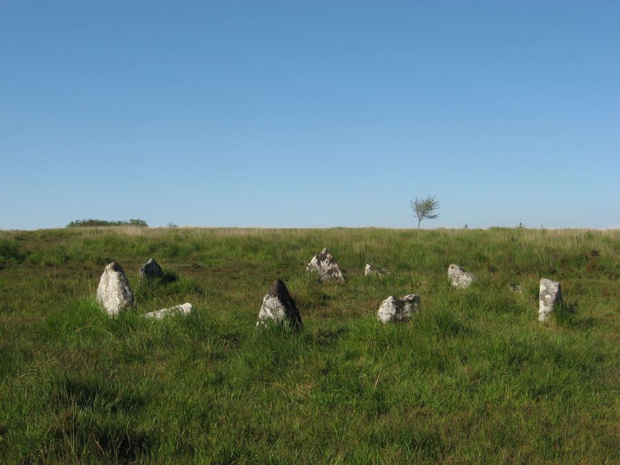
Photo taken on 22-07-2012
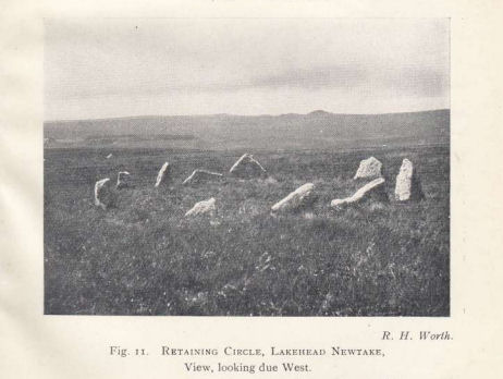
Photo by RHW. Barrow Report 54. TDA Vol.67 1935
Database entries
PDW coverage: Dartmoor Site: Lakehead Hill
OS Map: SX 64351 77493
OS Source: Google
Butler OS: SX64347750
HER: MDV52762
Megalithic Portal: 24365
Alternate name: Lakehead Hill 5
Short Name: CC Lakehead 5
Butler map: 27.19.5
Grinsell: LYDFORD 55
Turner: G24
DPD page: 117
Exist: Yes
Record: Unique
Record Source: Butler
Hut Class: No
Cairn Class: Yes
Barrow Report: 54
Dimensions (m): 6.8
Lidar: SX 64351 77493
Guide Map: 28
Nearest Bus Stop: Postbridge Bellever (1.6 km) [Route: 98]
Nearby sites: SX 64351 77493
Notes
Butler Cairn 5. Tuner lists this as G24 Stone Circle. However, it is clear from its size and location near other Ring Settings that it is in fact better described as a Ring Setting despite having no visible internal structure. In these listings we will leave it as a cairn circle. HER: A ring cairn lying on a gentle slope near the summit of Lakehead Hill. The cairn is defined by a circle of edge set stones which measure 7.8 metres in diameter and stand up to 0.9 metres high. DEC Report 3: A second small kistvaen within a circle exists on the west side of Lake Head Hill, and was examined, but nothing was found in it. The circle about it is tolerably complete and the stone chest has lost only one of the side-stones ; but it is very small. Apparently a small stone row led from it. Near the kistvaen is a circle of stones enclosing a cairn, but no kistvaen. From the circle perhaps a stone row led away east, but only three stones remain in line. Lethbridge diagram p.114 and photo top p.117.The author visited this site with Steve Szypko on 02/07/25 and we observed a stone in the centre - whether this is part of the monument or not is unclear. The photo is from a return on 09/07/25 and incorporates my boot for scale. We also looked for 3 stones reported as a stone row 40 metres (Butler) to the SE of this feature and failed to find them in very overgrown and tussocky terrain. There are many natural slabs in the area and the veracity of these old reports are hard to figure out. Looking again at the notes here maybe they were located to the *east*.

References
These are selected references with an emphasis on out of copyright sources linked as PDFs. For more detailed references try any linked HER or PMD record above.
- Butler, Jeremy, Dartmoor Atlas of Antiquities, vol.2: The North, (1991)
- Grinsell, L.V., Dartmoor Barrows, Devon Archaeological Society Proceedings No.36 (1978)
- Lethbridge, William D., Discover Preshistoric Dartmoor, (2015)
- Turner, J.R., Ring Cairns, stone circles and related monuments on Dartmoor, D.A.S.P. No.48 pp.27-86 (1990)
- Worth, R. Hansford, Barrow Report 54, T.D.A. Vol.67 pp.77-80 (1935)