
Trowlesworthy Warren (E) Cairn Circle
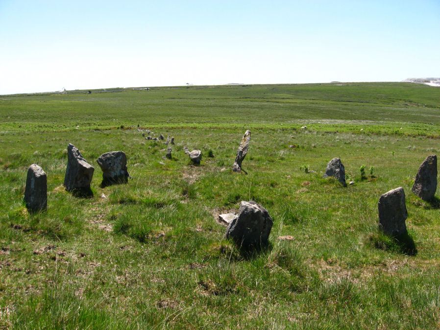
Photo taken on 17-06-2010
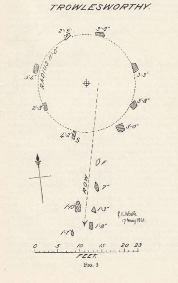
Plan by RHW Retaining circles associated with stone rows Dartmoor (1941)
Database entries
PDW coverage: Dartmoor Site: Trowlesworthy, Settlements, Stone Row & Cairn Circle
OS Map: SX 57651 63983
OS Source: Google
Butler OS: SX57646398
HER: MDV49511
Megalithic Portal: 529
PMD: Trowlesworthy E Stone Row
Alternate name: Trowlesworthy stone row 1
Short Name: CC Trowles E
Butler map: 51.8.1
Butler Vol 5: p.229 & Fig.163
Grinsell: SHAUGH PRIOR 44
Turner: G25
DPD page: 58
Exist: Yes
Record: Unique
Record Source: Butler
Hut Class: No
Cairn Class: Yes
Dimensions (m): 6.6 x 0
Lidar: SX 57651 63983
Guide Map: 53
Nearest Bus Stop: Lee Moor Clearview (2.9 km) [Route: 59]
Nearby sites: SX 57651 63983
Notes
Cairn circle at head of stone row. "The circle 6.5m. in diameter comprises eight orthostats from 0.7m. to 1.5m. high. In some cases the 'trig' stones are visible." "The alleged cairn at the head of the row comprises a ring of eight stones a maximum of 1.2m high with no evidence of a cist and very little to suggest the former presence of a cairn. It would seem more likely to represent the remains of a small stone circle albeit only 6.0 to 6.5m in diameter." See also, Legendary Dartmoor: The Pulpit. Lethbridge p.57-8, diagram p.58.The largest stone in the cairn circle has a spear like appearance as a consequence of being worked. A photo of the Spearstone is featured in Retaining circles associated with stone rows Dartmoor (1941) with the note "probably deformed by workmen in 1859". In the text of the article RHW states: "The tallest stone has been marked "S" on the plan, fig. 3; it is unusual in that it has obviously been shapen, being reduced on both the north and south, in such manner that it has a "waist" see plate VII. It seems improbable that this work upon the stone should date to the time of the construction of the circle, and subsequent interference is the more likely explanation.". Worth does not explain the relevance of 1859. It is a reference to the 1860 account by Rev. W. J. Coppard of Plympton who stopped the detsruction of the site. Quote: "To save the trouble of getting materials at a very trifling distance, the men were carrying off some of the stones from the avenue which was near at hand, and had blasted some of them with gunpowder". For more on this see PDW Coverage linked on this page. It seems likely the appearance of this stone is from the vandalism in 1859 but this does not seem to be known for certain.
References
These are selected references with an emphasis on out of copyright sources linked as PDFs. For more detailed references try any linked HER or PMD record above.
- Butler, Jeremy, Dartmoor Atlas of Antiquities, vol.3: The South-West, (1994)
- Butler, Jeremy, Dartmoor Atlas of Antiquities, vol.5: The Second Millennium B.C., (1997)
- Coppard, Rev. W. J., The Prevention of the Destruction of the Trowlesworthy Row, The Archaeological Journal, Vol.17 p.70 (1860)
- Grinsell, L.V., Dartmoor Barrows, Devon Archaeological Society Proceedings No.36 (1978)
- Lethbridge, William D., Discover Preshistoric Dartmoor, (2015)
- Page, John Lloyd Warden, An Exploration of Dartmoor and its Antiquities, with some account of its borders, (1889)
- Rowe, Samuel, A Perambulation of Dartmoor (3rd Edition), (1896)
- Turner, J.R., Ring Cairns, stone circles and related monuments on Dartmoor, D.A.S.P. No.48 pp.27-86 (1990)
- Wilkinson J. Gardner, British Remains on Dartmoor, Journal Brit. Arch. Assoc. xviii. pp.22-53, 111-133. (1862)
- Worth, R. Hansford, Retaining circles associated with stone rows Dartmoor, T.D.A. Vol.73 pp.227-38 (1941)
- Worth, R. Hansford, The Stone Rows of Dartmoor Part 1, T.D.A. Vol.78 pp.285-316 (1946)
- Worth, R.N., The Stone Rows of Dartmoor - Part 1, T.D.A. Vol.24 pp.387-417 (1892)