
Guide to the Monuments on Trowlesworthy Warren
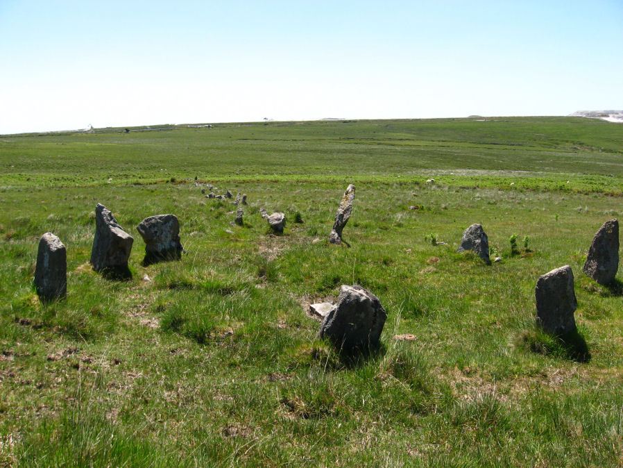
Table of Ritual and Burial Monuments on Trowlesworthy Warren
The following table lists the records currently in this Guide Map. For an explantion of the Guide Maps and a table of all 62 Guide Maps, follow this link: Guide List Table. Introductory text will be added to each guide list in 2025. Notes on duplication and omissions will appear below the table once checks have been finalised.
Notes on possible duplications and omissions
Tory Brookhead 2 The HER entry MDV5633 is for the Butler record 51.7.2. This is for a cairn located at SX 5833 6340. Butler: 6.5 metres diameter by 1.0 metres high to the west of Enclosure 'A' is still in good shape despite the trench excavated into one side.. Butler links his record to the Grinsell entry SHAUGH PRIOR 38. The HER record also has notes from historic England 2021 It has a hollow in its east side.The HER has a separate record MDV28541 for the Grinsell record SX 58326347 Cairn dug into from the south-east, diameter 8m by height 0.6m. The grid references do not entirely match but the overall descriptions are very similiar. Grinsell's grid references from 1976 are often a little inaccurate. In my view this is a duplicate.NB. Wigford Down cairns see also Guide to the Monuments on Wigford Down
PS. These notes are to assist untangling complicated records and are neither permanent nor a criticism of the HER who do a fantastic job! The author finds it easier to systematically work through these records (2000+ of them) and add these notes, which are then to be communicated with the HER, if appropriate, it is a pragmatic way of dealing with lots of data without continually stopping and starting.
Trowlesworthy Warren Guide Map
Guidance for walkers: The monuments featured in this database are archaeological treasures and need to be protected and preserved - please do not disturb any sites. Please check access and firing times before visiting sites, not all sites listed are on open access land. Firing ranges and boundaries of open access areas are marked on the OL28 OS Dartmoor Explorer map. Please stick to the country code and consider giving support to the numerous agencies that help to keep Dartmoor a fabulous natural and historic environment!
List of Ritual and Burial Monuments on Trowlesworthy Warren
Wigford Down 12 Cairn
OS Map: SX 55089 64982
HER record: MDV28543
ShortName: CN:Wigford 12
Butler map: 48.1.12
Grinsell: MEA 8
Notes: HER: One of three scheduled round cairns that lie outside the coaxial field system on Wigford Down and survive as circular mounds. This cairn measures 14.0 metres in diameter by 0.4 metres in height. All three show evidence for either partial early excavation or robbing. A mound is visible as a cropmark on digital images derived from aerial photographs of 2007 onwards and as a subtle earthwork on visualisations derived from lidar data captured between 1998 and 2017
Nearby sites: SX55096498
Wigford Down 13 Cairn
OS Map: SX 55256 64826
HER record: MDV2458
ShortName: CN:Wigford 13
Butler map: 48.1.13
Grinsell: MEA 9
Barrow Report: 12
Notes: HER: One of a pair of closely spaced grass-covered cairns around 60 metres south of Brisworthy China Clay Works. The mound is visible as a cropmark on digital images derived from aerial photographs of 2007 onwards and as a subtle earthwork on visualisations derived from lidar data captured between 1998 and 2017.
Nearby sites: SX55266483
Wigford Down 14 Cairn
OS Map: SX 55286 64807
HER record: MDV2459
ShortName: CN:Wigford 14
Butler map: 48.1.14
Grinsell: MEA 10
Barrow Report: 12
Notes: HER: One of a pair of closely spaced grass-covered cairns around 60 metres south of Brisworthy China Clay Works. The mound is visible as a cropmark on digital images derived from aerial photographs of 2007 onwards and as a subtle earthwork on visualisations derived from lidar data captured between 1998 and 2017.
Nearby sites: SX55296481
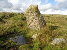
Hanging Stone Standing Stone
OS Map: SX 58372 63688
HER record: MDV2423
Megalithic Portal: 45568
The Stone Rows of GB: Lee Moor South
PMD: The Hanging Stone
Alternate name: The Hanging Stone Standing Stone
ShortName: SS Hanging
Butler Vol 5: p.53
DPD page: 59
Notes: Located on Lee Moor. "The 'Hanging Stone' or 'Leaning Rock', 7ft 9ins in length, but because of the stone being 38o out of the vertical, its vertical height is only 6ft 9ins. It measures 3ft 7ins by 1ft 10ins at the base, and is incised on one face with the letters "CB" showing that at one time it was used as a bound-post. It is believed to be prehistoric." TDA Vol. 72 1940 pp. 192-3 (R Hansford Worth). See also, Legendary Dartmoor: The Hanging Stone.
Nearby sites: SX58376369
Shaden Moor Cairn
OS Map: SX 54740 63500
HER record: MDV19894
ShortName: CN:Shaden Moor
Butler map: 48.2
Notes: Butler: "A single burial mound sited between the parallel reaves also miraculously survives, with no more damage than a lightly holllowed top".
Nearby sites: SX54746350
Saddlesborough pound A, wall cairn Reported Cairn
OS Map: SX 55931 63491
HER record: MDV125908
ShortName: CN?Saddlesbo5
Butler map: 48.3
Butler Vol 5: p.101 & Fig.59
Notes: Butler describes a cairn-like structure within the enclosure wall of Pound A. "A small cairn-like erection 3.5 m across projecting into the interior from the outer wall was probably a style support for access into the pound". Viewing Pound A in Google earth and comparing with Butler's diagram Fig. 59 gives a location of SX 55931 63491.
Nearby sites: SX55936349
Saddlesborough Stone Ring Cairn Circle
OS Map: SX 55870 63210
HER record: MDV2433
Megalithic Portal: 45840
Alternate name: Saddlesborough Summit Stone Ring Cairn Circle
ShortName: RC Saddlesboro
Butler map: 48.3
Turner: A45
Notes: "Stone ring with an annular bank. The interior is part infilled with small stones and boulders to 0.3 meters or less below the bank top. This cairn measures 15.5 meters in diameter, with a bank 1.3 meters wide and 0.4 meters high. The interior has been dug into. Situated on a level summit."
The two entries SiteID=545 and SiteID=1472 are probably correct but the area is disturbed by tin workings and further confirmation is required that the correct features have been identified in the field (in terms of photos - visit 12 Sep 2022). Grid references not updated due to doubt about ID.
Nearby sites: SX55876321
Saddlesborough N. Cairn
OS Map: SX 55890 63230
HER record: MDV28564
ShortName: CN Saddlesbo3
Butler map: 48.3
Notes: The two entries SiteID=545 and SiteID=1472 are probably correct but the area is disturbed by tin workings and further confirmation is required that the correct features have been identified in the field (in terms of photos - visit 12 Sep 2022). Grid references not updated due to doubt about ID.
Nearby sites: SX55896323
Saddlesborough E.1 Cairn Circle
OS Map: SX 56015 63179
HER record: MDV2553
ShortName: CN Saddlesbo1
Butler map: 48.3.1
Barrow Report: 7
Notes: "The remains of an impressive, though extensively disturbed ring cairn are located at SX56016317 on a gentle south-east facing slope 130 meters from the summit area of Saddlesborough at 298 meters above Ordnance Datum. It survives as an amorphous turf-covered ragged `rim' of stones." Possibly covered in Barrow Report 7.
Nearby sites: SX56026318
Saddlesborough E.2 Cairn
OS Map: SX 56070 63220
HER record: MDV79252
ShortName: CN:Saddlesbo2
Butler map: 48.3.2
Notes: HER: Probable prehistoric cairn on Shaugh Moor. This site is included in the local list of Nationally Important Dartmoor sites. A turf-covered mound at SX56086322 measuring 3.2 metres in diameter and a maximum 0.5 metres high located on the crest of a rise. No surface boulders or stones are evident.
Nearby sites: SX56076322
Emmets Post 1 Cairn
OS Map: SX 56786 63196
HER record: MDV2439
ShortName: CN:Emmets 1
Butler map: 48.3
Grinsell: SHA 42
Barrow Report: 12
Notes: "Oxford Archaeology carried out an excavation of an early Bronze Age barrow at Emmets Post, Dartmoor in advance of its destruction by quarrying. The investigation elucidated the sequence of construction of the monument, which comprised a primary turf mound and a central cairn that were subsequently buried beneath a larger secondary turf mound with a stone kerb. No human remains were found, although this is not unusual on Dartmoor, where unburnt bone does not survive due to acidity of the soil."
See also Historic England: Emmets Post.
Nearby sites: SX56796320
Emmets Post 2 Reported Cairn
OS Map: SX 56730 63170
HER record: MDV20150
ShortName: CN?Emmets 2
Grinsell: B:SHA 42a
Barrow Report: 12
Nearby sites: SX56736317
Shaugh Moor Stone Row
OS Map: SX 55422 63435
HER record: MDV2434
Megalithic Portal: 2121
The Stone Rows of GB: Shaugh Moor
PMD: Shaugh Moor Stone Row
Alternate name: Shaugh Moor row Stone Row
ShortName: SR ShaughMoor
Butler map: 48.5
DPD page: 55
Notes: "A single stone row 587 feet long, the spacing of the stones varies between 3 feet and 5 feet, centre to centre. At the Southwest end there is a retaining circle 50 feet in diameter. The stones of the row are very small and sunk into the peat, making them hard to find. A stone row 164m long aligned SW-NE over the brow and down the south side of the valley. The terminals are not intervisible. It is composed of small stones, normally between 35 and 10cm high, the tallest (65cms) being at the apparent northern terminal. Where the stones have been removed their original positions can be identified from depressions in the turf". Lethbridge p.54-55, diagram p.55. See also: Sea Views at Shaugh Moor
Nearby sites: SX55426344
Shaugh Moor (S) Cairn Circle
OS Map: SX 55419 63427
HER record: MDV49564
Megalithic Portal: 52567
PMD: Shaugh Moor Stone Row
Alternate name: Shaugh Moor stone row Cairn Circle
ShortName: CC ShaughMoorS
Butler map: 48.5
DPD page: 55
Grinsell: SHA 41
Turner: G17
Notes: Cairn circle at the southern end of the Shaugh Moor stone row. "An egg-shaped ring of stone uprights". "Only an arc of four clearly identifiable stones survive in the circle; they are a maximum 0.3m high and suggest an approximate circle diameter of 15.0m. There are a number of buried and semi-buried stones traceable but their relationship to the circle is unclear". Lethbridge p.54-55, diagram p.55
Nearby sites: SX55426343
Shaugh Moor (site of c.6) Cairnfield Master
OS Map: SX 55302 63502
HER record: MDV14571
ShortName: CN:ShaughNo M
Grinsell: SHA 49f
Notes: Destroyed - 6 excavated cairns 1979
Nearby sites: SX55306350
Shaugh Moor '1' Reported Cairn
OS Map: SX 55400 63600
HER record: MDV14788
Alternate name: Shaugh Moor '1' Reported Cairn
ShortName: CN:ShaughNo 1
Butler map: 48.5
Grinsell: SHA 41a
Notes: Destroyed. Excavated by Smith in 1979 - is this actually 49a?
Nearby sites: SX55406360
Shaugh Moor '2' Reported Cairn
OS Map: SX 55300 63500
HER record: MDV14790
Alternate name: Shaugh Moor '2' Reported Cairn
ShortName: CN:ShaughNo 2
Butler map: 48.5
Grinsell: SHA 49b
Notes: Destroyed. 6 cairns excavated by Smith in 1979. Grinsell 49a-49f (arbitrary allocation to Butler records)
Nearby sites: SX55306350
Shaugh Moor '4' Reported Cairn
OS Map: SX 55400 63600
HER record: MDV14775
Alternate name: Shaugh Moor '4' Reported Cairn
ShortName: CN:ShaughNo 4
Butler map: 48.5
Grinsell: SHA 49e
Notes: Destroyed. 6 cairns excavated by Smith in 1979. Grinsell 49a-49f (arbitrary allocation to Butler records)
Nearby sites: SX55406360
Shaugh Moor '70' Reported Cairn
OS Map: SX 55400 63600
HER record: MDV14773
Alternate name: Shaugh Moor '70' Reported Cairn
ShortName: CN:ShaughNo 70
Butler map: 48.5
Grinsell: SHA 49c
Notes: Destroyed. 6 cairns excavated by Smith in 1979. Grinsell 49a-49f (arbitrary allocation to Butler records)
Nearby sites: SX55406360
Shaugh Moor '71' Reported Cairn
OS Map: SX 55400 63600
HER record: MDV14774
Alternate name: Shaugh Moor '71' Reported Cairn
ShortName: CN:ShaughNo 71
Butler map: 48.5
Grinsell: SHA 49d
Notes: Destroyed. 6 cairns excavated by Smith in 1979. Grinsell 49a-49f (arbitrary allocation to Butler records)
Nearby sites: SX55406360
Shaugh Moor '126' Reported Cairn
OS Map: SX 55300 63500
HER record: MDV14789
Alternate name: Shaugh Moor '126' Reported Cairn
ShortName: CN:ShaughNo126
Butler map: 48.5
Grinsell: SHA 49a
Notes: Destroyed. 6 cairns excavated by Smith in 1979. Grinsell 49a-49f (arbitrary allocation to Butler records)
Nearby sites: SX55306350
Shaugh Cross Platform Cairn Circle
OS Map: SX 55320 63460
HER record: MDV2524
Megalithic Portal: 17513
Alternate name: Saddlesborough reave Platform Cairn Circle
ShortName: PC:ShaughCross
Butler map: 48.5
Grinsell: SHA 40
Turner: E2
Notes: A barrow lies 109.7m west from the retaining circle (sx56se/24) of the stone row on shaugh moor. There is a kerb of stones visible and a wider spread of material up to 12.19m (worth). Barrow diam 12.19m, height 1.524m.
Nearby sites: SX55326346
Shaugh Moor Platform Cairn Circle
OS Map: SX 55476 63479
HER record: MDV2572
Megalithic Portal: 52699
Alternate name: Saddlesborough N.W. Platform Cairn Circle
ShortName: PC Shaugh Moor
Butler map: 48.5
Grinsell: SHA 41b
Turner: E3
Notes: Ring cairn or traces of cairn with retaining circle, found by plymouth archaeological group 1959. Diameter 11.5m, height 0.3m. No.416. Vis=-/7/1959 (ancient monuments). Cairn, height 2ft, diameter 30ft, east of and close to stone row. Distinct stone kerb with low flat mound within.
Nearby sites: SX55486348
Shaugh Moor (N) Cairn Circle
OS Map: SX 55419 63496
HER record: MDV5596
Megalithic Portal: 3458
Alternate name: Shaugh Moor N.1 Cairn Circle
ShortName: CC ShaughMo N1
Turner: G18
Notes: "Whether the stones represent the remnants of a stone circle, a cairn circle, or even a hut is debateable". "The remains of a circle of stones lie on a north-west facing hill slope at 256m above OD on unenclosed moorland. It survives as a partial ring of five boulder and stones with an off-centre earthfast boulder; the overall diameter was approximately 10.0m to 10.6m across. The largest of the two slabs which remain upright is 0.8m high, 1.7m wide and 0.3m thick."
Nearby sites: SX55426350
Shaugh Moor N.2 Cairn
OS Map: SX 55380 63470
HER record: MDV67980
ShortName: CN:ShaughMo N2
Notes: HER: A low rectangular-shaped mound with a pronounced lynchet on its downhill side. Lying on a gentle west-facing slope and covered by close cropped moorland turf it is 6.0m long, 3.0m wide and up to 0.4m high. Slight linear depressions on each of the long sides suggest side ditches. There are no visible stones or boulders in the mound. Its origin and function are not clear.
Nearby sites: SX55386347
Shaugh Moor Enclosed Settlement
OS Map: SX 55655 63455
HER record: MDV12778
Megalithic Portal: 17512
ShortName: ES:Shaugh Moor
Notes: Butler Vol 3 Map 48, 3. See Fig 48.3 p.100 for diagram of enclosures A-G. The best defined is enclosure A which is around 250 metres to the east of this grid reference. This grid reference marks a squarish enclosure G.
Nearby sites: SX55666346
Shaugh Lake Reported Cairn
OS Map: SX 55800 63600
HER record: MDV131555
ShortName: CN?ShaughLake
Butler map: 48.5
Grinsell: SHA 47a
Barrow Report: 15
Notes: SX 560 635. (approx.) A small barrow excavated by R H Worth in 1896 revealed little of interest beyond a platform or hearth of granite and a rounded flint
Nearby sites: SX55806360
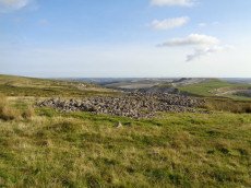
Trowlesworthy Warren Enclosed Settlement
OS Map: SX 57499 64442
HER record: MDV2507
Megalithic Portal: 34075
ShortName: ES:Trowles S
Notes: "A sub-circular enclosure about 150 paces in diameter situated on the western slope of Trowlesworthy Tor, the wall unbroken except for entrances on the north and south sides. Inside the southern entrance is a hut circle. The structures at the two entrances are vermin traps, these and the square chamber having been built by warreners"
Nearby sites: SX57506444
Trowlesworthy Enclosed Settlement
OS Map: SX 57459 64536
HER record: MDV2530
Megalithic Portal: 34064
ShortName: ES:Trowles N
Notes: "Two adjoining enclosures containing four hut circles and two other contemporary structures on the W flank of Lee Moor some 300m W of Little Trowelsworthy Tor. The enclosures measure 24m N to S by 34m and 63m N to S by 46m. Both are bounded by substantial stony banks up to 2.5m wide and 0.9m high."
Nearby sites: SX57466454
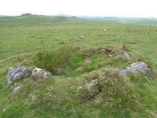
Trowlesworthy Warren Platform Cairn Circle and Cist
OS Map: SX 57146 64757
HER record: MDV28570
Megalithic Portal: 45773
PMD: Trowlesworthy Warren
ShortName: CT Trowles
Butler map: 51.1
DPD page: 55
Grinsell: SHA 30a
Turner: E40
Notes: "A round cairn and cist, located 370 metres east of Trowlesworthy Warren House. The cairn mound measures 5.2 metres in diameter and stands up to 0.1 metres high. Its perimeter is defined by a kerb of at least eight stones." One side stone is missing, capstone present. Lethbridge p.54-5 Trowlesworthy Farm Cist - diagram p.54, photo p.55. Butler Vol. 3. Map 51.1 (diagram p.158).
Nearby sites: SX57156476
Shell Top W.1 Cairn
OS Map: SX 59110 63780
HER record: MDV56855
ShortName: CN:ShellTop W1
Butler map: 51.4.1
Notes: Round cairn. Mound measures 8.5 metres north-south by 7 metres east-west and stands up to 1.1 metres high. Two separate hollows dug into the mound suggest partial early excavation or robbing. A post medieval boundary stone lies at the west-south-west foot of the mound and may have once stood upright on the cairn.
Nearby sites: SX59116378
Shell Top W.2 Reported Cairn
OS Map: SX 58970 63790
HER record: MDV56856
ShortName: CN:ShellTop W2
Butler map: 51.4.2
Butler Vol 5: p.24 & Fig.5
Notes: Cairn or hut circle?
Nearby sites: SX58976379
Shell Top W.3 Cairn
OS Map: SX 58615 63978
HER record: MDV2517
ShortName: CN:ShellTop W3
Butler map: 51.4.3
Grinsell: SHA 37
Nearby sites: SX58626398
Shell Top W.4 Cairn
OS Map: SX 58490 64000
HER record: MDV2516
ShortName: CN:ShellTop W4
Butler map: 51.4.4
Grinsell: SHA 36
Nearby sites: SX58496400
Shell Top W.5 Cairn
OS Map: SX 58450 63730
HER record: MDV56849
ShortName: CN:ShellTop W5
Butler map: 51.4.5
Nearby sites: SX58456373
Shell Top W.6 Cairn
OS Map: SX 58639 63720
HER record: MDV103579
ShortName: CN:ShellTop W6
Nearby sites: SX58646372
Shell Top W.7 Cairn
OS Map: SX 58684 63695
HER record: MDV56852
ShortName: CN:ShellTop W7
Nearby sites: SX58686370
Great Trowlesworthy Cairn Circle
OS Map: SX 58390 64590
HER record: MDV28533
ShortName: CC:Trowles
Butler map: 51.5
Notes: "An incomplete circle of largely recumbent granite boulders on the gently sloping W flank of Lee Moor. The ring measures 9.9m north-south by 9.4m with a gap in the eastern side. The interior lies at the same level as the surrounding ground surface." See Butler Volume 3 pp.162-3, Map 51, Figure 51.6 'Ring of stones' shown to the west of Settlement 'B' at 'Upper Spanish Lake'. Not listed in Butler's cairn listing.
Nearby sites: SX58396459
Upper Spanish Lake 1 Reported Cist
OS Map: SX 58626 64360
HER record: MDV42216
PMD: Lee Moor S1
ShortName: CT:U Spanish 1
Butler map: 51.5.1
Grinsell: SHA 35
Notes: Cairn mound, measuring approximately 3 metres in diameter and standing 0.5 metres high. The end and side slabs of the cist are in situ but the coverstone is missing. There are traces of a possible retaining kerb. Scheduled.
Nearby sites: SX58636436
Upper Spanish Lake 2 Reported Cist
OS Map: SX 58586 64351
HER record: MDV2418
PMD: Lee Moor S2
ShortName: CT U Spanish 2
Butler map: 51.5.2
Grinsell: SHA 34
Notes: Cairn, measuring roughly 3 metres in diameter and 0.3 metres high. The end and side slabs of the cist survive but the coverstone is missing.
Nearby sites: SX58596435
Lee Moor (Upper Spanish Lake) Cist
OS Map: SX 58549 64450
HER record: MDV2495
Megalithic Portal: 45753
PMD: Lee Moor
Alternate name: Upper Spanish Lake 3 Cist
ShortName: CT U Spanish 3
Butler map: 51.5.3
DPD page: 54
Grinsell: SHA 31
Barrow Report: 63
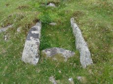
Notes: Part of a group of cairns very close together, see also NMR record SX56 SE4. "A small round cairn, 5.0m. diameter and 0.5m. high, on a gentle, well drained, clitter strewn, west facing slope at 355m. above OD. It is built of small boulders, now turf covered, and a cist lies within the cairn on the south-east side. The cist comprises the side and end stones, measures internally 0.7m. by 0.6m. wide, and is aligned on a grid bearing of 130o. The cover-stone is missing". Lethbridge p.54 Spanish Lake Cist. Butler Upper Spanish Lake 3 (Cairn 3) - Vol. 3. Map 51.5 (pp.162-4 general plan of Upper Spanish Lake huts and cairns p.163, diagram of cist p.164).
Nearby sites: SX58556445
Upper Spanish Lake 4 Cairn Circle
OS Map: SX 58553 64459
HER record: MDV42010
ShortName: CN U Spanish 4
Butler map: 51.5.4
Grinsell: SHA 32
Barrow Report: 63
Notes: A hollowed-out cairn measuring 6.5m N to S by 6.4m and 0.9m high. There are no traces of a cist though some protruding stones on the E side may indicate the presence of a former kerb. A stone-lined hollow 2.5m in diameter and 0.6m deep lies in the centre of the mound and probably represents its reuse as a military training feature.
Nearby sites: SX58556446
Upper Spanish Lake 5 Reported Cist
OS Map: SX 58570 64490
HER record: MDV12786
PMD: Lee Moor E.
ShortName: CN:U Spanish 5
Butler map: 51.5.5
Grinsell: SHA 33
Notes: Alledged cairn found Sept 1975. Possibly natural feature. Radcliffe lists as possible cist noting comment from Butler: "The rather smaller upper cairn may also have held a cistas the edge of a narrow slab is visible near the centre" Vol 3 p.163
Nearby sites: SX58576449
Tory Brookhead 1 Cairn
OS Map: SX 58880 63040
HER record: MDV12938
ShortName: CN?ToryBrook 1
Butler map: 51.7.1
Notes: A hut circle converted to a cairn accordig o Butler.
Nearby sites: SX58886304
Tory Brookhead 2 Cairn
OS Map: SX 58337 63413
HER record: MDV5633
ShortName: CN:ToryBrook 2
Butler map: 51.7.2
Grinsell: SHA 38
Notes: HER: Cairn 800 metres east-north-east of Big Pond lies on the south west facing slope of Lee Moor south of Cross Dyke reave and south west of Cholwich Town contour reave. It consists of a mound 8 metres in diameter and 0.5 metres in height, with a high proportion of stone in its make up. It has a hollow in its east side. The cairn lies west of several enclosures and stone hut circles which are the subject of separate schedulings. Despite some disturbance the cairn survives well in an area containing numerous monuments relating to settlement, land use and burial in the Bronze Age period.
Nearby sites: SX58346341
Tory Brookhead 2 (duplicate) Reported Cairn
OS Map: SX 58320 63470
HER record: MDV28541
ShortName: CN:ToryBk 2Dup
Notes: The HER have separated out the Grinsell record HER SHAUGH PRIOR 38 (SX 5832 6347) from the Butler record 51.7.2 (SX 5833 6340). This author believes they relate to the same feature and for this reason this record is marked as a duplicate. HER: (May 1976) SX 58326347 Cairn dug into from the south-east, diameter 8m by height 0.6m.
Nearby sites: SX58326347
Tory Brookhead 2 (duplicate) Cairn
OS Map: SX 58320 63470
HER record: MDV2422
ShortName: CN:ToryBk2Dup
Notes: This is a duplicate of HER MDV5633 which is Grinsell Shaugh Prior 38 and Butler Torybrookhead 2 (51.7.2)
Nearby sites: SX58326347
Shell Top Chambered Cairn
OS Map: SX 58690 63517
HER record: MDV2411
Megalithic Portal: 45852
Alternate name: Tory Brookhead 3 Chambered Cairn
ShortName: CN ToryBrook 3
Butler map: 51.7.3
DPD page: 59
Grinsell: SHA 39
Notes: "A Bronze Age round cairn on a well drained south west facing slope. The cairn mound measures 26 metres by 24 metres and stands up to 1.2 metres high. The centre is much disturbed, with many hollows, up to 1m deep, which have been interpreted as chambers, but are most probably modern windbreak shelters. Two small satellite cairns lie immediately to the north west." Lethbridge suggests a chambered cairn, see photos Lethbridge p.59-60 Chambered Cairn - diagram p.59
Nearby sites: SX58696352
Tory Brookhead 4 Cairn
OS Map: SX 58689 63544
HER record: MDV20149
ShortName: CN:ToryBrook 4
Butler map: 51.7.4
Grinsell: SHA 39a
Nearby sites: SX58696354
Tory Brookhead 5 Cairn
OS Map: SX 58678 63525
HER record: MDV53393
ShortName: CN:ToryBrook 5
Nearby sites: SX58686353
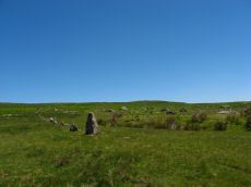
Trowlesworthy E. Stone Row
OS Map: SX 57646 63972
HER record: MDV2421
Megalithic Portal: 3516
The Stone Rows of GB: Trowlesworthy 1
PMD: Trowlesworthy E Stone Row
Alternate name: Trowlesworthy 1 Stone Row
ShortName: SR Trowles E
Butler map: 51.8.1
Butler Vol 5: p.229 & Fig.163
DPD page: 57
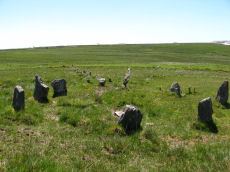
Notes: Butler Trowlesworthy 1. "A Bronze Age stone alignment comprising a double stone row consisting of 99 upright and 8 recumbent stones running south-south-west from a possible stone circle near the foot of the south flank of Little Trowlesworthy Tor. The surviving length of the row is about 129 metres, it is bisected by a leat. The better preserved element of the row is down the slope from the leat. The circle comprises 8 main orthostat stones in a "kidney-shaped" plan. The south-west orthostat in the ring is surrounded by a number of smaller stones". Lethbridge p.57-8, diagram p.58. See also, Legendary Dartmoor: The Pulpit and Sea Views at Trowlesworthy 1
Nearby sites: SX57656397
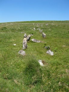
Trowlesworthy W. Stone Row
OS Map: SX 57536 63978
HER record: MDV2415
Megalithic Portal: 2176
The Stone Rows of GB: Trowlesworthy 2
PMD: Trowlesworthy W Stone Row
Alternate name: Trowlesworthy 2 Stone Row
ShortName: SR Trowles W
Butler map: 51.8.2
DPD page: 58
Notes: Butler Trowlesworthy 2. "A single stone row consisting of 35 upright and 13 recumbent stones running in an E to W line from the site of a possible ring cairn at the foot of the SW flank of Little Trowlesworthy Tor. The cairn at the head of the row is marked by a circle containing one upright and eight fallen small slabs and boulders. Within these is a slightly raised area, perhaps the remains of a cairn." Lethbridge p.57-8, diagram p.58.
Nearby sites: SX57546398
Trowlesworthy Warren (E) Cairn Circle
OS Map: SX 57651 63983
HER record: MDV49511
Megalithic Portal: 529
PMD: Trowlesworthy E Stone Row
Alternate name: Trowlesworthy stone row 1 Cairn Circle
ShortName: CC Trowles E
Butler map: 51.8.1
Butler Vol 5: p.229 & Fig.163
DPD page: 58
Grinsell: SHA 44
Turner: G25
Notes: Cairn circle at head of stone row. "The circle 6.5m. in diameter comprises eight orthostats from 0.7m. to 1.5m. high. In some cases the 'trig' stones are visible." "The alleged cairn at the head of the row comprises a ring of eight stones a maximum of 1.2m high with no evidence of a cist and very little to suggest the former presence of a cairn. It would seem more likely to represent the remains of a small stone circle albeit only 6.0 to 6.5m in diameter." See also, Legendary Dartmoor: The Pulpit. Lethbridge p.57-8, diagram p.58.
Nearby sites: SX57656398
Trowlesworthy Warren (W) Cairn Circle
OS Map: SX 57544 63986
HER record: MDV49509
Megalithic Portal: 3517
PMD: Trowlesworthy W Stone Row
Alternate name: Trowlesworthy stone row 2 Cairn Circle
ShortName: CC Trowles W
Butler map: 51.8.2
Grinsell: SHA 43
Turner: G26
Notes: This is a cairn circle at the east end of the Trowlesworthy Warren (W) stone row. "At the east is a 4.5m. diameter circle of 10 stones; average height 0.4m. There is no visible cairn or cist in the centre. Two upright stones immediately to the north west of the circle are probably associated. "
Nearby sites: SX57546399
Trowelsworthy (NMR 439396) Reported Cairn
OS Map: SX 57430 63950
HER record: MDV28568
ShortName: CNxTrowelswo1
Notes: Hut circle. NMR suggests ring cairn.
Nearby sites: SX57436395
Trowlesworthy Cairn
OS Map: SX 56890 64900
HER record: MDV129216
ShortName: CN:Trowles1
Nearby sites: SX56896490
Trowlesworthy stone row 2 (duplicate) Cairn
OS Map: SX 57550 63990
HER record: MDV131550
ShortName: CC TrowlWDup
Notes: HER: Grinsell records a cairn here; duplication of cairn MDV49509.
Nearby sites: SX57556399
Shaugh Moor Clearance Cairn
OS Map: SX 55830 63540
HER record: MDV131553
ShortName: CN:Shaugh
Notes: HER: A turf-covered stone ? clearance mound 3.3m in diameter and 0.5m high. The visible fist sized stones appear to be solely of the bluish local granite, some with fine quartz veins. The impression is that this particular type of coloured stone was selected for the mound. Investigated and surveyed at 1:2500 scale as part of the Shaugh Moor project in 1997.
Nearby sites: SX55836354
Trowlesworthy Clearance Cairn
OS Map: SX 57580 63860
HER record: MDV32085
ShortName: CN:Trowles2
Notes: HER: The cleared ground survives as irregular area 30m by 25m defined by natural undisturbed clitter. Within the cleared area is a cairn which measures 6m by 5m and stands up to 0.4m high. This is probably a clearance cairn produced during the clearance of the area. Whilst dating of these features on the basis of surface remains alone is impossible, it is perhaps interesting to note their location midway between two stone alignments. Survey in 2002 suggested this may be a natural feature.
Nearby sites: SX57586386
Trowlesworthy Cairn
OS Map: SX 57000 64700
HER record: MDV52663
ShortName: CN:Trowles3
Notes: HER: irregular turf mound in which some stones visible.10m long, 4m wide, 1m high. Oriented ne-sw.
Nearby sites: SX57006470
Shady Back Tor Clearance Cairn
OS Map: SX 56490 64810
HER record: MDV56749
ShortName: CN:ShadyBack
Notes: HER: At SX 5649 6481 and SX 5650 6481. Two clearance cairns adjacent to an historic field system on the west facing slope of Shady Back Tor. Both mounds are covered in loose rubble and are considered to be of post-Medieval date.
The western mound lies partly within the southern ditch of pillow mound (PRN 43428), measures 7m in diameter and stands up to 0.5m high.
The eastern mound measures 4m by 2.5m and 0.2m high.
Nearby sites: SX56496481
Page last updated 10/12/24