
Royal Hill, South Platform Cairn Circle and Cist
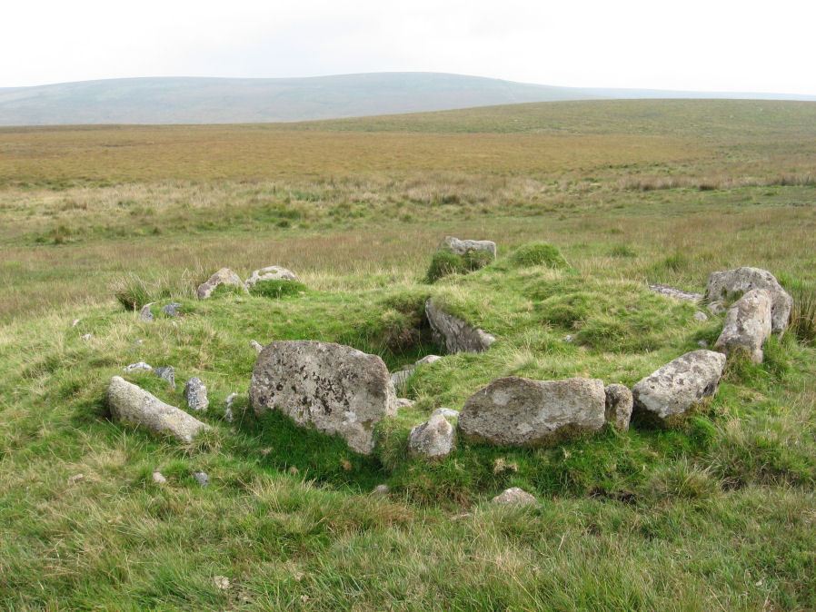
Photo taken on 13-09-2014
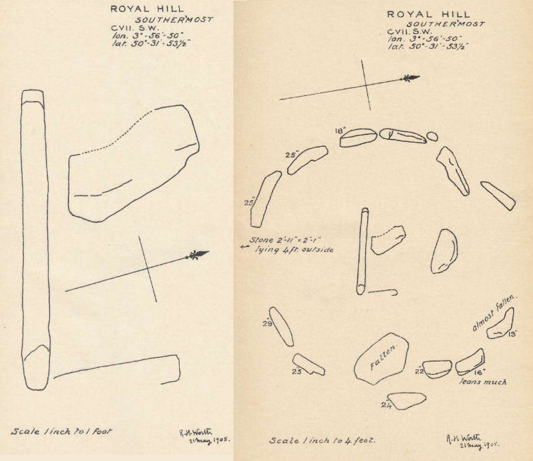
Plans by RHW. Barrow Report 27. TDA Vol.40 1908
Database entries
OS Map: SX 62020 72091
OS Source: Google
Butler OS: SX62017208
HER: MDV6309
Megalithic Portal: 34958
PMD: Royal Hill SE.
Alternate name: Royal Hill E.3
Short Name: CT RoyalHill 3
Butler map: 65.5.3
Dixon Cist #: 22
Grinsell: LYDFORD 88
Turner: E31
DPD page: 98
Exist: Yes
Record: Unique
Record Source: Butler
Hut Class: No
Cist Class: Yes
Cairn Class: Yes
Barrow Report: 27 47
Dimensions (m): 4.7 x 0.5 C
Lidar: SX 62020 72091
Guide Map: 39
Nearest Bus Stop: Two Bridges Hotel (4.0 km) [Route: 98,171,172]
Nearby sites: SX 62020 72091
Notes
"The cairn is 4.9m in diameter and 0.4m high with a flattish, platform, top. It is retained by a kerb of almost contiguous orthostats, the largest 1.1m long, 0.2m thick, and 0.6m high. A few are fallen or displaced. The central cist is oriented WNW to ESE, lacking both cover stone and N side slab. Internally it measures 1.35m by 0.75m by 0.55m deep." Lethbridge diagram p.97 Cist A, photo p.98. Butler Royal Hill E. 3 - Vol. 4. Map 65.5 (Cairn 3 - diagram p.233). Breton p.19.References
These are selected references with an emphasis on out of copyright sources linked as PDFs. For more detailed references try any linked HER or PMD record above.
- Breton, Henry Hugh, The Heart of Dartmoor, (1926)
- Burnard, Robert, Notes on Dartmoor Kistvaens, T.D.A. Vol.22 pp.200-207 (1890)
- Butler, Jeremy, Dartmoor Atlas of Antiquities, vol.4: The South-East, (1993)
- Grinsell, L.V., Dartmoor Barrows, Devon Archaeological Society Proceedings No.36 (1978)
- Turner, J.R., Ring Cairns, stone circles and related monuments on Dartmoor, D.A.S.P. No.48 pp.27-86 (1990)
- Worth, R. Hansford, Barrow Report 27, T.D.A. Vol.40 pp.84-85 (1908)
- Worth, R. Hansford, Barrow Report 47, T.D.A. Vol.60 pp.77-78 (1928)