
Royal Hill, North Ring Setting Cairn and Cist
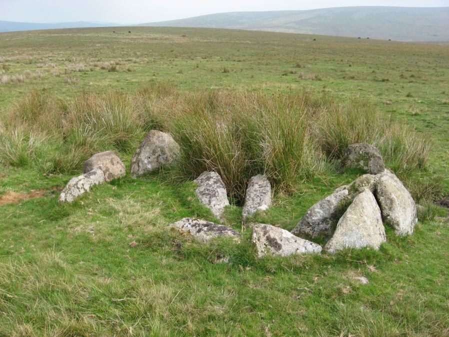
Photo taken on 13-09-2014
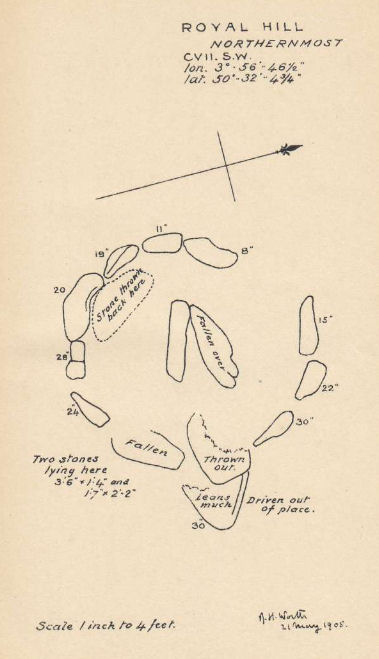
Plan by RHW. Barrow Report 27. TDA Vol.40 1908
Database entries
OS Map: SX 62108 72434
OS Source: Google
Butler OS: SX62117242
HER: MDV6305
Megalithic Portal: 34959
PMD: Royal Hill NE.
Alternate name: Royal Hill E.5
Short Name: CT RoyalHill 5
Butler map: 65.5.5
Dixon Cist #: 24
Grinsell: LYDFORD 90
Turner: D21
DPD page: 98
Exist: Yes
Record: Unique
Record Source: Butler
Hut Class: No
Cist Class: Yes
Cairn Class: Yes
Barrow Report: 27 47
Dimensions (m): 3.0 x 0.3 C
Lidar: SX 62108 72434
Guide Map: 39
Nearest Bus Stop: Two Bridges Hotel (3.6 km) [Route: 98,171,172]
Nearby sites: SX 62108 72434
Notes
"The circle is 3.1m in overall diameter, comprising nine contiguous thick slabs, up to 0.9m long and from 0.3m to 0.7m high... There is virtually no cairn material but the interior has been levelled up to a height of 0.1m on the E, downhill side. A central cist oriented WNW to ESE is represented by two side stones which protrude 0.15m above ground. They are 1.2m and 0.9m long and both about 0.2m thick and 0.4m deep. The longer, northern one leans inwards and touches the other at the W end; at the E the stones are 0.8m apart separated by two flat (packing ?) stones each about 0.35m across. An overgrown and embedded slab against the circle W if the cist may have been an end stone." Lethbridge diagram p.97 Cist C, photo p.98. Butler Royal Hill E. 5 (Cairn 5 - diagram p.233)- Vol. 4. Map 65.5. Central cist. Breton p.19.References
These are selected references with an emphasis on out of copyright sources linked as PDFs. For more detailed references try any linked HER or PMD record above.
- Breton, Henry Hugh, The Heart of Dartmoor, (1926)
- Burnard, Robert, Notes on Dartmoor Kistvaens, T.D.A. Vol.22 pp.200-207 (1890)
- Butler, Jeremy, Dartmoor Atlas of Antiquities, vol.4: The South-East, (1993)
- Grinsell, L.V., Dartmoor Barrows, Devon Archaeological Society Proceedings No.36 (1978)
- Turner, J.R., Ring Cairns, stone circles and related monuments on Dartmoor, D.A.S.P. No.48 pp.27-86 (1990)
- Worth, R. Hansford, Barrow Report 27, T.D.A. Vol.40 pp.84-85 (1908)
- Worth, R. Hansford, Barrow Report 47, T.D.A. Vol.60 pp.77-78 (1928)