
Crock of Gold Ring Setting Cairn and Cist
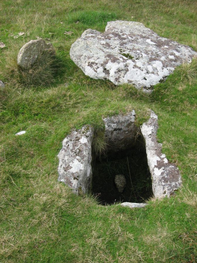
Photo taken on 13-09-2014
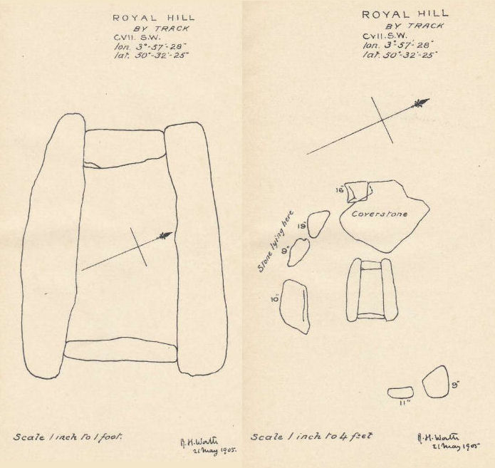
Plan by RHW. Barrow Report 27. TDA Vol.40 1908
Database entries
OS Map: SX 61286 73076
OS Source: Google
Butler OS: SX61287306
HER: MDV6308
Megalithic Portal: 14960
PMD: The Crock of Gold
Alternate name: Crock of Gold
Short Name: CT CrockofGold
Butler map: 65.2
Dixon Cist #: 25
Grinsell: LYDFORD 86
Turner: D17
DPD page: 101
Exist: Yes
Record: Unique
Record Source: Butler
Hut Class: No
Cist Class: Yes
Cairn Class: Yes
Barrow Report: 27 47 56
Dimensions (m): 4.0 x 0.3 C
Lidar: SX 61286 73076
Guide Map: 39
Nearest Bus Stop: Two Bridges Hotel (2.6 km) [Route: 98,171,172]
Nearby sites: SX 61286 73076
Notes
"The cairn, 7m in overall diameter and 0.3m high, has a flattish top with a retaining circle set 1m to 1.5m within the perimeter. This consists of six earthfast boulders, about 0.4m across and protruding a similar height above the cairn ... A central cist is oriented NW to SE. Internally it is 0.8m long, 0.4m wide at the NW end, 0.5m at the SE, and 0.7m deep. The side slabs are 1m long and respectively 0.15m and 0.25m thick; the end slabs, 0.5m long and 0.1m thick. The capstone, moved to the W, is 1.3m long, 1.1m wide and 0.15m thick and now rests against the kerb." Lethbridge diagram p.102 Cist(C), photo p.101. Butler Vol. 4. Map 65.2 (diagram p.229).References
These are selected references with an emphasis on out of copyright sources linked as PDFs. For more detailed references try any linked HER or PMD record above.
- Burnard, Robert, Notes on Dartmoor Kistvaens, T.D.A. Vol.22 pp.200-207 (1890)
- Butler, Jeremy, Dartmoor Atlas of Antiquities, vol.4: The South-East, (1993)
- Grinsell, L.V., Grinsell, Folklore of Prehistoric Sites in England, (1976)
- Grinsell, L.V., Dartmoor Barrows, Devon Archaeological Society Proceedings No.36 (1978)
- Turner, J.R., Ring Cairns, stone circles and related monuments on Dartmoor, D.A.S.P. No.48 pp.27-86 (1990)
- Worth, R. Hansford, Barrow Report 21, T.D.A. Vol.34 pp.104- 146 (1902)
- Worth, R. Hansford, Barrow Report 27, T.D.A. Vol.40 pp.84-85 (1908)
- Worth, R. Hansford, Barrow Report 47, T.D.A. Vol.60 pp.77-78 (1928)
- Worth, R. Hansford, Barrow Report 56, T.D.A. Vol.69 pp.75-109 (1937)