
Blakey Tor (E) Cist
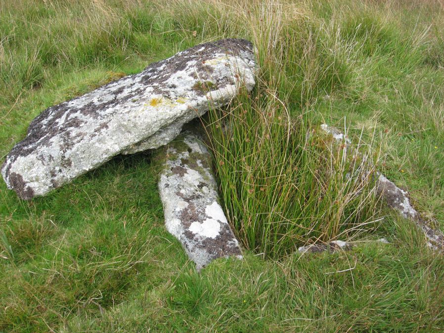
Photo taken on 13-09-2014
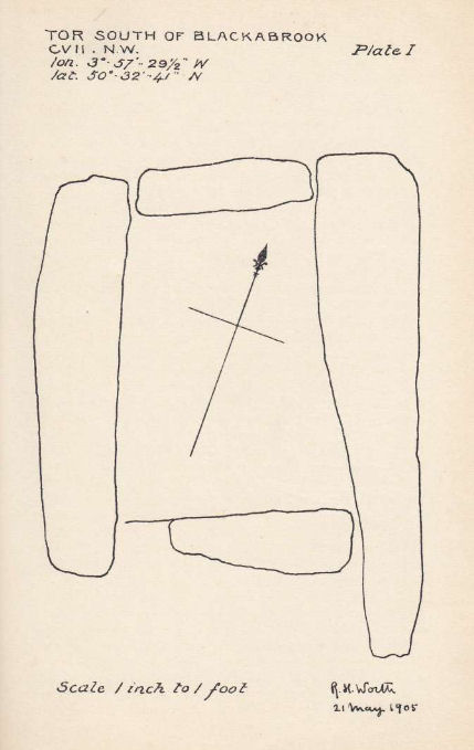
Plan by RHW. Barrow Report 31. TDA Vol.44 1912
Database entries
OS Map: SX 61312 73558
OS Source: Google
Butler OS: SX61307355
HER: MDV6245
Megalithic Portal: 28869
PMD: Blakey Tor E.
Alternate name: Blakey Tor E.
Short Name: CT Blakey Tor
Butler map: 65.4
Dixon Cist #: 30
Grinsell: LYDFORD 85
DPD page: 102
Exist: Yes
Record: Unique
Record Source: Butler
Hut Class: No
Cist Class: Yes
Cairn Class: Yes
Barrow Report: 31 47
Dimensions (m): 4.0 x 0.2 C
Lidar: SX 61312 73558
Guide Map: 34
Nearest Bus Stop: Two Bridges Hotel (2.0 km) [Route: 98,171,172]
Nearby sites: SX 61312 73558
Notes
"A reed-filled cist is set well into the cairn on a NNW-SSE axis. The intact chamber measures internally 0.95m long, a maximum 0.65m wide and 0.45m deep; the longest side slab is 1.4m by 0.3m by 0.45m and largest end slab 0.55m by 0.2m by 0.4m. The coverstone against the NW side of the cist is roughly oval in shape and measures 1.7m by 1.3m and a maximum 0.25m thick." Lethbridge diagram p.102 Cist(B), photo p.102. Butler Vol. 4. Map 65.4 (diagram p.232).References
These are selected references with an emphasis on out of copyright sources linked as PDFs. For more detailed references try any linked HER or PMD record above.
- Butler, Jeremy, Dartmoor Atlas of Antiquities, vol.4: The South-East, (1993)
- Grinsell, L.V., Dartmoor Barrows, Devon Archaeological Society Proceedings No.36 (1978)
- Prowse, Arthur B., The Antiquities of Ockery and Roundhill, T.D.A. Vol.33 pp.495-499 (1901)
- Worth, R. Hansford, Barrow Report 31, T.D.A. Vol.44 pp.83-5 (1912)
- Worth, R. Hansford, Barrow Report 47, T.D.A. Vol.60 pp.77-78 (1928)