
Goldsmith's Cross S. Cist
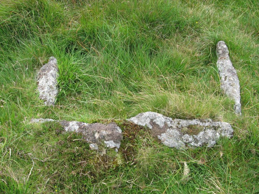
Photo taken on 15-08-2015
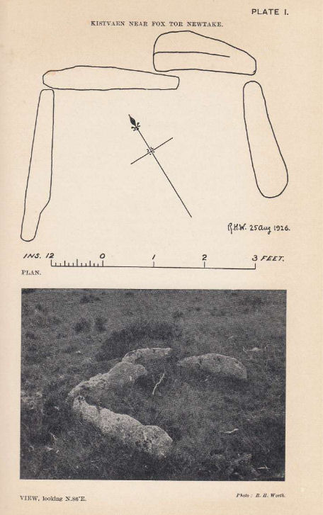
Plan by RHW. Barrow Report 46. TDA Vol.59 1927
Database entries
OS Map: SX 61684 69872
OS Source: Garmin
Butler OS: SX61676988
HER: MDV5081
Megalithic Portal: 42708
PMD: Fox Tor Mires S 5
Alternate name: Goldsmiths Cross S.
Short Name: CT Goldsmith S
Butler map: 64.5
Dixon Cist #: 44
Grinsell: LYDFORD 100
DPD page: 97
Exist: Yes
Record: Unique
Record Source: Butler
Hut Class: No
Cist Class: Yes
Cairn Class: Yes
Barrow Report: 46 56
Dimensions (m): 1.2 x 0.85 C
Lidar: SX 61684 69872
Guide Map: 44
Nearest Bus Stop: Princetown Dartmoor Visitor Centre (5.9 km) [Route: 98,171(20/07/26 to 19/09/26)]
Nearby sites: SX 61684 69872
Notes
"The remains of a cist lie some 80m E of the Whealam stream works at SX 61666985, on gently sloping ground 50m S of the newtake wall. The remains consist of four granite slabs set into the ground, forming three sides of a trapezoidal structure. It measures 1.2m long and a maximum of 0.85m wide. The long side, unusually formed of two granite slabs, is oriented NW to SE. The maximum height which the stones protrude above the ground is 0.2m. The SW side of the structure is missing; there are no traces of a capstone or cairn".Lethbridge diagram p.93, text p.96, photo top p.97. Butler Goldsmith's Cross S. - Vol. 4. Map 64.5. (Cairn 4 - diagram p.221). Worth (1927) suggests the following description is of this cist. Breton (1926 p.22)
About 1 m E. of Nun's Cross farm, on the W side of the dip formed by a lateral stream of the Strane (it is the first valley at W. foot of Fox Tor) are the remains of this kistvaen. A block of white spa will be seen in the wall which is one's companion from Nun's cross to Fox Tor. The kistvaen lies about 60 yds S.E. of he white spa and about 45 yds. in a direct line from the wall, and 100 yds E. of the stream..
References
These are selected references with an emphasis on out of copyright sources linked as PDFs. For more detailed references try any linked HER or PMD record above.
- Breton, Henry Hugh, The Heart of Dartmoor, (1926)
- Breton, Henry Hugh, Beautiful Dartmoor And Its Interesting Antiquities, (1990)
- Butler, Jeremy, Dartmoor Atlas of Antiquities, vol.4: The South-East, (1993)
- Grinsell, L.V., Dartmoor Barrows, Devon Archaeological Society Proceedings No.36 (1978)
- Lethbridge, William D., Discover Preshistoric Dartmoor, (2015)
- Worth, R. Hansford, Barrow Report 46, T.D.A. Vol.59 pp.69-70 (1927)
- Worth, R. Hansford, Barrow Report 56, T.D.A. Vol.69 pp.75-109 (1937)