
Lakehead Hill 2 Cist
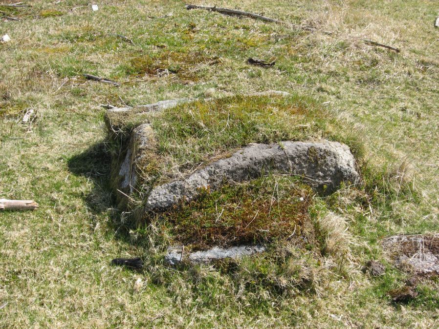
Photo taken on 15-05-2010
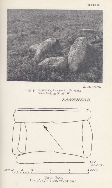
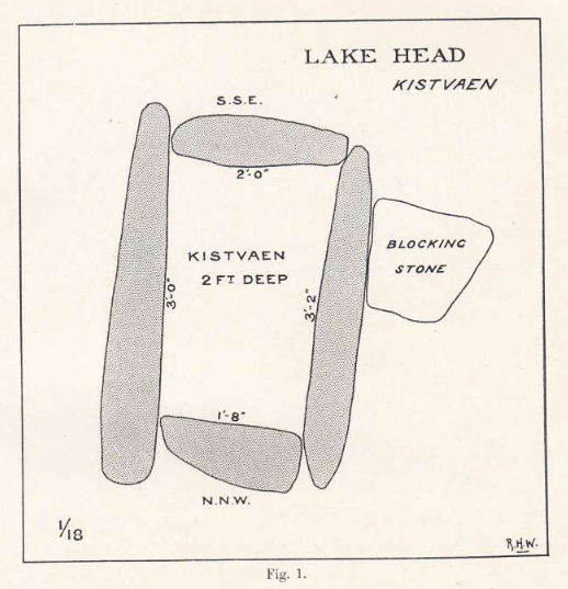
Plan by RHW. Barrow Report 55. TDA Vol.68 1936
Database entries
PDW coverage: Dartmoor Site: Lakehead Hill
OS Map: SX 64261 77701
OS Source: Garmin
Butler OS: SX64257769
HER: MDV5841
Megalithic Portal: 4612
PMD: Lakehead Hill NW.
Alternate name: Lakehead Hill 2
Short Name: CT Lakehead 2
Butler map: 27.19.2
Dixon Cist #: 66
Grinsell: LYDFORD 52
DPD page: 115
Exist: Yes
Record: Unique
Record Source: Butler
Hut Class: No
Cist Class: Yes
Cairn Class: Yes
Barrow Report: 17 55
Dimensions (m): 1.35 x 0.9 C
Lidar: SX 64261 77701
Guide Map: 28
Nearest Bus Stop: Postbridge Post Office (1.7 km) [Route: 98,171]
Nearby sites: SX 64261 77701
Notes
HER: The remains of a cairn on Lakehead Hill. It includes an 8 metre diameter and 0.1 metre high mound containing a north west to south east orientated cist measuring 0.9 metres long by 0.55 metres wide. The cist is now backfilled and protrudes 0.4 metres high above the present land surface. Part excavation of the cist in 1898 by the Dartmoor Exploration Committee, revealed flint knives and scrapers together with pottery fragments and charcoal. Scheduled. Further coverage on Lakehead Hill page. Lethbridge diagram p.114 and photos top p.115. Butler Lakehead Hill (Cairn 2 diagrams pp.48-52).Plan R.H. Worth Barrow Report 17 (1898).
References
These are selected references with an emphasis on out of copyright sources linked as PDFs. For more detailed references try any linked HER or PMD record above.
- Burnard, Robert, Notes on Dartmoor Kistvaens, T.D.A. Vol.22 pp.200-207 (1890)
- Burnard, Robert, Early Man, The Victoria History of the County of Devon: v. 1 (1906)
- Butler, Jeremy, Dartmoor Atlas of Antiquities, vol.2: The North, (1991)
- Grinsell, L.V., Dartmoor Barrows, Devon Archaeological Society Proceedings No.36 (1978)
- Lethbridge, William D., Discover Preshistoric Dartmoor, (2015)
- Worth, R. Hansford, Barrow Report 17, T.D.A. Vol.30 pp. (1898)
- Worth, R. Hansford, Barrow Report 55, T.D.A. Vol.68 pp.49-50 (1936)