
Guide to the Monuments on Lakehead Hill
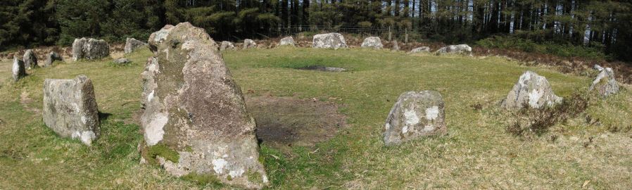
Table of Ritual and Burial Monuments on Lakehead Hill
The following table lists the records currently in this Guide Map. For an explantion of the Guide Maps and a table of all 62 Guide Maps, follow this link: Guide List Table. Introductory text will be added to each guide list in 2025. Notes on duplication and omissions will appear below the table once checks have been finalised.
Notes on possible duplications and omissions
Pizwell Bridge Cairn: MDV53010 (Pizwell Bridge Cairn) is a duplicate of MDV5987 as stated on MDV53010.PS. These notes are to assist untangling complicated records and are neither permanent nor a criticism of the HER who do a fantastic job! The author finds it easier to systematically work through these records (2000+ of them) and add these notes, which are then to be communicated with the HER, if appropriate, it is a pragmatic way of dealing with lots of data without continually stopping and starting.
Lakehead Hill Guide Map
Guidance for walkers: The monuments featured in this database are archaeological treasures and need to be protected and preserved - please do not disturb any sites. Please check access and firing times before visiting sites, not all sites listed are on open access land. Firing ranges and boundaries of open access areas are marked on the OL28 OS Dartmoor Explorer map. Please stick to the country code and consider giving support to the numerous agencies that help to keep Dartmoor a fabulous natural and historic environment!
List of Ritual and Burial Monuments on Lakehead Hill

Riddon Ridge N. Reported Cairn
OS Map: SX 66140 77230
HER record: MDV132303
ShortName: CN Riddon N
Butler map: 18.1.24
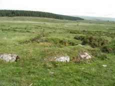
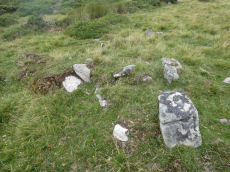
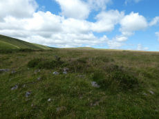
Notes: The remains of a disturbed turf-covered cairn. The monument measures 10.5 by 8.5 metres and stands to a height of 0.75 metres. The cairn shows signs of disturbance as a shallow hollow slightly west of centre and a possible spoil heap lies nearby.
UPDATE: 28/12/24. This entry had previously been linked incorrectly to details of a round house a little distance away - photo and grid reference was incorrect. Now linked to correct HER entry.
Nearby sites: SX66147723
Riddon Ridge E. Reported Cairn
OS Map: SX 67070 76880
HER record: MDV132298
ShortName: CNxRiddon E
Butler map: 18.2.10
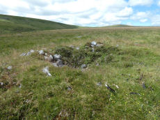
Notes: The mound appears to be a spoil heap of stones removed from short stretches of this reave. HER Grid Ref is SX 6703 7692 which is some distance from the Butler NGR of SX 6707 7688. This record has been reverted to the Butler NGR.
Nearby sites: SX67077688
Cator Pound
OS Map: SX 67300 77650
HER record: MDV6009
Megalithic Portal: 34961
ShortName: PD Cator Pound
Notes: HER: Cator pound, widecombe. In his survey of widecombe made about 1750, dean milles describes 'a very considerable circle of stones on the n part of the western down on a farm called cator and on an eminence called whitehill'; he gives the diameter as 58 paces and says it consisted 'chiefly of large stones mowst of which rise about 4 feet above ye ground. This circle consists now of about 30 stones but there are spaces where several more stood, half the number are fallen; the rest are either erect or on their sides'.
Nearby sites: SX67307765
Cator Common Embanked Cairn Circle
OS Map: SX 67426 78001
HER record: MDV5978
Megalithic Portal: 52173
ShortName: CC CatorCommon
Butler map: 18.4
Grinsell: WID 1
Turner: B3
Notes: HER: Cairn, hollow towards centre. Retaining circle of c.28 upright slabs, mostly turned inwards. Diameter 18.0m, height 0.6m. Breton p.41
Nearby sites: SX67437800
Grendon Farm (Hill W of) Cairn Circle
OS Map: SX 68050 78350
HER record: MDV6008
ShortName: CN:GrendonFarm
Grinsell: WID 1a
Notes: HER: Cairn located on highest point of hill west of Grendon Farm, measuring 12 metres in diameter, composed of small stones overgrown with gorse and heather. Disturbed on the eastern side.
Nearby sites: SX68057835

Cator Common Platform Cairn Circle and Cist
OS Map: SX 67118 77510
HER record: MDV5987
Megalithic Portal: 45793
PMD: Pizwell Bridge
Alternate name: Pizwell Bridge Platform Cairn Circle and Cist
ShortName: CT Pizwell 1
Butler map: 18.5
Butler Vol 5: p.171 & Fig.110
Grinsell: WID 2
Turner: E10
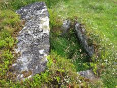
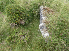
Notes: "Pizwell Bridge cairn of circa 5m diameter by 0.5m high is to be found about 10m below the road in an unusual position near the base of the hill. Three retaining slabs form an arc around one side with another just under the turf. The top of a slab near the centre with a pit alongside might be one side of a cist. ". Butler Pizwell Bridge Vol. 1. Map 18.5 (diagram Vol 5. p.171). Possible central cist.
Nearby sites: SX67127751
Pizwell Bridge (duplicate) Reported Cairn
OS Map: SX 67200 77500
HER record: MDV53010
ShortName: CT?Pizwell 2
Notes: Duplicate of HER 5987, see: Pizwell Bridge Platform Cairn Circle and Cist
Nearby sites: SX67207750
Soussons Common Ring Setting Cairn and Cist
OS Map: SX 67516 78700
HER record: MDV6013
Megalithic Portal: 1266
PMD: Soussons Plantation
Alternate name: Soussons Plantation S. Ring Setting Cairn and Cist
ShortName: CT Soussons Cm
Butler map: 24.2.6
DPD page: 124
Grinsell: MAN 9
Turner: D2
Barrow Report: 22 23 45 56
Notes: "A 28 feet diameter cairn circle with a central cist (plan). The tallest stone in the cairn circle is about 2 feet high." "This cist measures at least 1.3 metres long by 0.5 metres wide and when excavated in 1903 two coils of human hair were found". Lethbridge p.124. Butler Soussons Plantation S - Vol. 2. Map 24.2.6 (diagrams pp. 18-20). Breton p.41.
Nearby sites: SX67527870
Arch Tor Platform Cairn Circle
OS Map: SX 63168 77843
HER record: MDV21510
Megalithic Portal: 45618
Alternate name: Arch Tor 1 Platform Cairn Circle
ShortName: PC Arch Tor 1
Butler map: 27.6
Turner: E11
Notes: "A round cairn which survives as an 8.7 metre diameter mound standing up to 0.9 metres high. Large edge set stones on the north western edge of the mound may suggest the presence of a kerb which survives elsewhere as a buried feature."
Nearby sites: SX63177784
Arch Tor 2 Reported Cairn
OS Map: SX 63610 78370
HER record: MDV52787
ShortName: CN?Arch Tor 2
Notes: three small cairns
Nearby sites: SX63617837
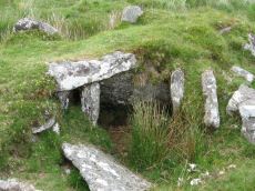
Stennen Hill No. 1 Platform Cairn Circle and Cist
OS Map: SX 62573 77905
HER record: MDV5846
Megalithic Portal: 45736
PMD: Powder Mills W.
Alternate name: Stennen Hill 1 Platform Cairn Circle and Cist
ShortName: CT Stennen 1
Butler map: 29.11.1
Butler Vol 5: p.199 & Fig.142
DPD page: 111
Grinsell: LYD 47
Turner: E13
Barrow Report: 57
Notes: "Cist lies approximately in the centre of a subcircular cairn measuring 7 by 6.5m the longer axis and cist aligned nne to ssw. It is stony but almost turf-covered with 2 large kerbstones, including burnards `menhir' remaining in situ in the nw. The cist is flush with the cairn top, which is flattish and stands only 0.2m high on the nw but up to 0.7m high on the se, downhill side. This may be the cairn's original form; built into the slope as a flat platform with the cist visible (nmr citing pattison)". See also HER. Lethbridge photo top p.111. Butler Stennen Hill 1 - Vol. 2. Map 29.11 (diagram Vol. 5. p.199). NB. Worth & Grinsell name this Stennen Hill No. 1. Breton p.34.
Nearby sites: SX62577791
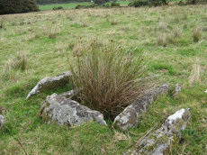
Stennen Hill No. 3 Cist
OS Map: SX 62615 77838
HER record: MDV5847
Megalithic Portal: 45737
PMD: Powder Mills E.
Alternate name: Stennen Hill 2 Cist
ShortName: CT Stennen 2
Butler map: 29.11.2
Butler Vol 5: p.200 & Fig.143
DPD page: 111
Grinsell: LYD 49
Barrow Report: 57
Notes: "cist is oriented nw. - se. And is open with the south west side stone and the end stone buried beneath the turf. Internal dimensions 1.3m by 0.85m depth 0.5m. The mound, which is slight with a height of 0.3m is much disturbed. Judging by the remains of the retaining circle of which six stones can be seen the diameter of the mound was 4.5m. Condition of the cist is fair, of mound poor." Only one large stone remains in the mound of a cairn. Lethbridge photo top p.111. Butler Stennen Hill 2 - Vol. 2. Map 29.11 (diagram Vol. 5. p.200). NB. Worth & Grinsell name this Stennen Hill No. 3 (It is Butler 2). Breton p.34.
Nearby sites: SX62627784
Stennen Hill 3 Cairn
OS Map: SX 62265 78280
HER record: MDV52785
ShortName: CN Stennen 3
Nearby sites: SX62277828
Stennen Hill 4 Reported Cairn
OS Map: SX 62404 78661
HER record: MDV52786
ShortName: CN?Stennen 4
Nearby sites: SX62407866
Stennen Hill 5 Reported Cairn
OS Map: SX 62402 77797
HER record: MDV5849
ShortName: CN Stennen 5
Grinsell: LYD 50a
Notes: Hut circle. There are disturbed remains here within a prehistoric settlement. It seems likely these remains are of a round house.
Nearby sites: SX62407780
Stennen Hill 6 Reported Cairn
OS Map: SX 62431 77794
HER record: MDV5850
ShortName: CN Stennen 6
Grinsell: LYD 50b
Notes: Hut circle
Nearby sites: SX62437779
Stennen Hill 7 Reported Cairn
OS Map: SX 62525 77877
HER record: MDV5848
ShortName: CN Stennen 7
Grinsell: LYD 50
Notes: Hut Circle NMR A. There are disturbed remains here within a prehistoric settlement. It seems likely these remains are of a round house. Breton p.34-35.
Nearby sites: SX62537788
Stennen Hill 8 Reported Cairn
OS Map: SX 62570 77880
HER record: MDV13520
ShortName: CNxStennen 8
Grinsell: LYD 48
Barrow Report: 57
Notes: Hut Circle NMR B. Barrow report 57: "Fifty-four feet from the centre of the last describedkistvaen, on a bearing S.3t'W., lies the centre of a retainingcircle of 16 feet 6 inches internal diameter, the lar5;est stoneof which is 7 feet by 6 inches on plan, and stands 3 feet inheight. There are but slight traces of the mound, and thereis no indication of a kistvaen." This is a duplicate of the record for the round house site 6512. NB. Worth & Grinsell name this Stennen Hill No.2 (It is Butler 9)
Nearby sites: SX62577788
Higher White Tor (site of) Reported Cist
OS Map: SX 62200 78600
HER record: MDV5969
PMD: Whiten Tor - Stennen Hill
ShortName: CT?H White Tor
Grinsell: LYD 50c
Notes: "This site was apparently excavated in 1827, when human hair was found (Grinsell cites Bray), but this site has not been located since this time - site / location not confirmed."
"The cist on east side of Great Whiten Tor, Postbridge" (Higher White Tor at SX 619785) was examined and revealed faint indications of bone ash contained in a pit 1foot 10inches diameter and 1foot 4inches deep. The pit was covered by a flat stone nearly 2 feet square. The coverstone of the cist had been removed to one side. Cannot be located today."
NB Grinsell suggests SX624780 as the grid reference
Nearby sites: SX62207860
Rowtor Brook 1 Cairn
OS Map: SX 62786 78626
HER record: MDV5837
ShortName: CN RowtorBr 1
Butler map: 27.17.1
Grinsell: LYD 44
Notes: HER: The eastern of a pair of cairns, measures 9.4 metres diameter and 1.1 metre high. Was excavated around 1900 by the Dartmoor Exploration Committee and has a central depression 2.8 metres across 1.0 metre deep. This work revealed a pit filled with wood charcoal, which 'probably originally contained burnt bones'.
Nearby sites: SX62797863
Rowtor Brook 2 Cairn
OS Map: SX 62702 78664
HER record: MDV5836
ShortName: CN RowtorBr 2
Butler map: 27.17.2
Grinsell: LYD 43
Notes: HER: The western of a pair of cairns. Composed of medium-size stones, measuring 9.6 metres east to west and 8.2 metres north to south and standing 0.8 metres high. Has a central depression 3.0 metres, 0.3 metres deep; spoil from it has produced a slight widening of the eastern arc, with two piles of removed stones adjacent.
Nearby sites: SX62707866
Archerton S.W. (Rowtor Brook) Ring Setting Cairn and Cist
OS Map: SX 62752 78808
HER record: MDV5838
Megalithic Portal: 37604
PMD: Hollowcombe Bottom
Alternate name: Rowtor Brook 3 Ring Setting Cairn and Cist
ShortName: CT RowtorBr 3
Butler map: 27.17.3
Butler Vol 5: p.55 & Fig.33
DPD page: 112
Grinsell: LYD 42
Turner: D24
Barrow Report: 57
Notes: Breton: on N. side of wall is a kistvaen, around which is a triple circle, a very unusual feature..
HER: The cist lies within three concentric circles of stones at 10, 15 and 24 feet diameters, the inner ring being of large stones, the middle ring of smaller stones and the outer ring of even smaller stones. The cist measures internally 0.8m by 0.6m and 0.9m deep. Half of its capstone lies across its north end.
For more information see: Lethbridge Hollowcombe Bottom, diagram and photo p.112. Butler Rowtor Brook 3 - Vol. 2. Map 27.17 (diagram Vol. 5. p.55). Breton p.35
Nearby sites: SX62757881
Archerton Tennis Ground Platform Cairn Circle and Cist
OS Map: SX 63852 78872
HER record: MDV5839
Megalithic Portal: 37599
PMD: Archerton Tennis Court
Alternate name: Archerton Platform Cairn Circle and Cist
ShortName: CT Arch Tennis
Butler map: 27.18
DPD page: 114
Grinsell: LYD 45
Turner: E49
Barrow Report: 57
Notes: Lethbridge diagram p.112, photo top p.114. Butler Archerton - Vol. 2. Map 27.18. Breton p.37 Its four sides are complete, the capstone is partially buried; it stands on a slight mound and has been enclosed by a circle of small stones which are nearly buried under the turf.
Nearby sites: SX63857887
Archerton Settlement
OS Map: SX 64100 78800
HER record: MDV5931
Megalithic Portal: 42727
ShortName: ST:Archerton
Notes: An oval pound now planted with trees. Rowe noted remains of banks and a hut within the enclosure. Prowse mentions traceable sub-division banks with distinct evidence of nine hut circles and a further one, ten yards diameter, "close outside on the east". See: T.D.A. Vol. 23 pp.311-12
Nearby sites: SX64107880
Kraps Ring Enclosed Settlement
OS Map: SX 64444 78157
HER record: MDV5861
Megalithic Portal: 11477
ShortName: ES:KrapsRing
Notes: HER: A large sub-circular enclosure of 120 metres by 113 metres containing at least nine hut circles, almost entirely surrounded by the mature conifers in Bellever Plantation. There are two hut circles associated with the enclosure outside the pound wall on the south-western side.
Nearby sites: SX64447816
Lakehead Hill S.W. Stone Row
OS Map: SX 64180 77300
HER record: MDV5844
Megalithic Portal: 45595
PMD: Lakehead Hill 6 Stone Row
ShortName: SRxLakehead SW
Butler map: 27.19.1
Notes: HER: Alleged Stone row recorded in 1946 but covered by a forestry plantation in 1979. At that time, 3 stones were visible, but it was uncertain whether they were part of the stone row. It may have been destroyed or covered by humus. Butler: Worth records a stone row on the south-west side of Lakehead Hill but this area has been overplanted and nothing can now be seen. The row was about 123 metres long orientated to the north-east and without any associated cairn.
Nearby sites: SX64187730
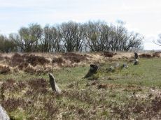
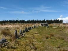
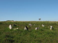
Lakehead Hill Summit Stone Row
OS Map: SX 64367 77656
HER record: MDV5930
Megalithic Portal: 2010
The Stone Rows of GB: Lakehead Hill Summit
PMD: Lakehead Hill 3 Stone Row
Alternate name: Lakehead Hill summit Stone Row
ShortName: SR LakeheadSum
Butler map: 27.19.3
DPD page: 115
Notes: HER: A stone alignment lying on a gentle slope near the summit of Lakehead Hill. It includes a 22 metre long, single row of at least 12 stones standing up to 0.75 metres high, aligned east to west.. Lethbridge diagram p.114 and photo bottom p.115.
Nearby sites: SX64377766
Lakehead Hill 4 (E of Summit) Stone Row
OS Map: SX 64498 77603
HER record: MDV5870
Megalithic Portal: 2009
The Stone Rows of GB: Lakehead Hill East
PMD: Lakehead Great Cairn Stone Row
Alternate name: Lakehead Hill E Stone Row
ShortName: SR Lakehead E
Butler map: 27.19.4
DPD page: 116
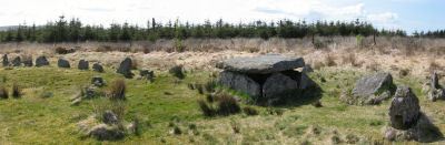
Notes: HER: A stone alignment and a cairn with cist lying on a gentle slope near the summit of Lakehead Hill. The stone alignment survives as a single row of at least 11 stones leading westward towards the cairn and cist. The cairn measures 6.7 metres in diameter and is defined by several edge set stones, which in turn surround a large restored cist formed by five substantial upright slabs supporting a capstone measuring 2.2 metre long by 1.55 metres wide and 0.3 metres thick. Lethbridge diagram p.114 and photos p.116.
Nearby sites: SX64507760
Lakehead Hill S.E. Stone Row
OS Map: SX 64701 77409
HER record: MDV5875
Megalithic Portal: 44544
The Stone Rows of GB: Lakehead Hill 2
PMD: Lakehead Hill 2 Stone Row
Alternate name: Lakehead Hill 2 Stone Row
ShortName: SR Lakehead SE
Butler map: 27.19.7
Butler Vol 5: p.184 & Fig.127
DPD page: 118
Barrow Report: 54
Notes: R.N. Worth The cist was examined in 1895/6 but nothing was found. It was surrounded by a double retaining circle and a stone row lead from it north west, of which ten stones remained, but these had sunk into the bog leaving only their tops showing. SRGB states: This description makes it clear that this is unlikely to be a stone row since a row composed of small stones would not have survived the ditch digging involved in the building of the hedge. It is much more likely that they represented stones exposed in the side of the ditch. HER also has: The stone row which falls in an afforested area could not be identified and has probably been destroyed
Nearby sites: SX64707741
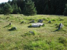
Lakehead Hill Platform Cairn Circle
OS Map: SX 64358 77773
HER record: MDV5869
Megalithic Portal: 1057
Alternate name: Lakehead Hill 1 Platform Cairn Circle
ShortName: PC Lakehead 1
Butler map: 27.19.1
DPD page: 114
Grinsell: LYD 53
Turner: E16
Barrow Report: 55
Notes: HER: A ring cairn lying on a gentle slope near the summit of Lakehead Hill. The cairn survives as a 6 metre diameter circle of upright slabs standing up to 0.4 metres high surrounding a slightly raised area. In the centre of the circle is a small 0.15 metre high mound. Lethbridge diagram p.114 and photo bottom p.114.
Nearby sites: SX64367777
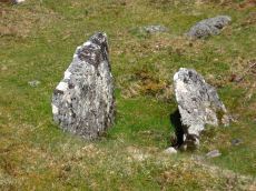
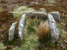
Lakehead Hill 2 Cist
OS Map: SX 64261 77701
HER record: MDV5841
Megalithic Portal: 4612
PMD: Lakehead Hill NW.
ShortName: CT Lakehead 2
Butler map: 27.19.2
DPD page: 115
Grinsell: LYD 52
Barrow Report: 17 55
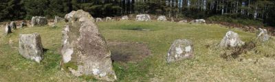
Notes: HER: The remains of a cairn on Lakehead Hill. It includes an 8 metre diameter and 0.1 metre high mound containing a north west to south east orientated cist measuring 0.9 metres long by 0.55 metres wide. The cist is now backfilled and protrudes 0.4 metres high above the present land surface. Part excavation of the cist in 1898 by the Dartmoor Exploration Committee, revealed flint knives and scrapers together with pottery fragments and charcoal. Scheduled. Further coverage on Lakehead Hill page. Lethbridge diagram p.114 and photos top p.115. Butler Lakehead Hill (Cairn 2 diagrams pp.48-52).
Nearby sites: SX64267770
Lakehead Hill 4 (E or Summit) Ring Setting Cairn and Cist
OS Map: SX 64499 77611
HER record: MDV5870
Megalithic Portal: 2009
PMD: Lakehead Hill Summit
Alternate name: Lakehead Hill 4 Ring Setting Cairn and Cist
ShortName: CT Lakehead 4
Butler map: 27.19.4
Butler Vol 5: p.59 & Fig.37
DPD page: 116
Grinsell: LYD 54
Turner: D6
Notes: A single stone row of at least 11 stones leading westward towards the cairn and cist. HER: The cairn measures 6.7 metres in diameter and is defined by several edge set stones, which in turn surround a large restored cist formed by five substantial upright slabs supporting a capstone measuring 2.2 metre long by 1.55 metres wide and 0.3 metres thick. Further coverage on Lakehead Hill page. Lethbridge diagram p.114 and photo top p.116. Butler Lakehead Hill (Cairn 4) - Vol. 2. Map 27.19.4 (diagrams pp.48-52). Breton p.35-36
Nearby sites: SX64507761
Lakehead Hill Cairn Circle
OS Map: SX 64351 77493
HER record: MDV52762
Megalithic Portal: 24365
Alternate name: Lakehead Hill 5 Cairn Circle
ShortName: CC Lakehead 5
Butler map: 27.19.5
DPD page: 117
Grinsell: LYD 55
Turner: G24
Barrow Report: 54
Notes: Butler Cairn 5. Tuner lists this as G24 Stone Circle. However, it is clear from its size and location near other Ring Settings that it is in fact better described as a Ring Setting despite having no visible internal structure. In these listings we will leave it as a cairn circle. HER: A ring cairn lying on a gentle slope near the summit of Lakehead Hill. The cairn is defined by a circle of edge set stones which measure 7.8 metres in diameter and stand up to 0.9 metres high.
Nearby sites: SX64357749
Lakehead Hill 6 (Newtake) Ring Setting Cairn and Cist
OS Map: SX 64363 77475
HER record: MDV5842
Megalithic Portal: 24365
PMD: Lakehead Hill Central
Alternate name: Lakehead Hill 6 Ring Setting Cairn and Cist
ShortName: CT Lakehead 6
Butler map: 27.19.6
DPD page: 117
Grinsell: LYD 56
Turner: D10
Barrow Report: 54 56
Notes: Further coverage on Lakehead Hill page. Lethbridge diagram p.114 and photo bottom p.117. Dixon #64. Bar Rep 54. Butler Lakehead Hill (Cairn 6) - Vol. 2. Map 27.19.6 (diagrams pp.48-52). HER: On a gentle slope near the summit of Lakehead Hill is a ring cairn and cist. The cairn measures 6.9 metres in diameter and contains a central cist. The cist protrudes 0.4 metres above the surrounding ground surface and is covered by a capstone measuring 1.7 metres long, 1.28 metres wide and 0.15 metre thick. DEC Report 3: A second small kistvaen within a circle exists on the west side of Lake Head Hill, and was examined, but nothing was found in it. The circle about it is tolerably complete and the stone chest has lost only one of the side-stones ; but it is very small. Apparently a small stone row led from it. Near the kistvaen is a circle of stones enclosing a cairn, but no kistvaen. From the circle perhaps a stone row led away east, but only three stones remain in line.
Nearby sites: SX64367748
Lakehead Hill 7 (Newtake) Cist
OS Map: SX 64720 77395
HER record: MDV5875
Megalithic Portal: 11137
PMD: Lakehead Hill E.
Alternate name: Lakehead Hill 7 Cist
ShortName: CT Lakehead 7
Butler map: 27.19.7
Butler Vol 5: p.184 & Fig.127
DPD page: 118
Grinsell: LYD 57
Barrow Report: 54
Notes: Butler Lakehead Hill (Cairn 7) - Vol. 2. Map 27.19.7 (diagrams pp.48-52).Further coverage on Lakehead Hill page. Lethbridge diagram p.114 and photo top p.118.
Nearby sites: SX64727740
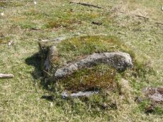
Lakehead Hill 8 Cist
OS Map: SX 64717 77178
HER record: MDV5879
Megalithic Portal: 24377
PMD: Lakehead Hill SE.
ShortName: CT Lakehead 8
Butler map: 27.19.8
Butler Vol 5: p.61 & Fig.41
DPD page: 118
Grinsell: LYD 58
Barrow Report: 33 55
Notes: HER: Southern of two cists to east of trackway on south side of Lakehead Hill. The cist, which lies in a small cairn 4.5 metres diameter, is orientated north-north-west to south-south-east. Only three sides of the cist survive; the cap stone has also gone. It was excavated in 1914 when a pit containing charcoal was found.. Further coverage on Lakehead Hill page. Lethbridge diagram p.114 and photo bottom p.118. Butler Lakehead Hill (Cairn 8) - Vol. 2. Map 27.19.8 (diagrams pp.48-52). Discovered by Mr. George French of Postbridge.
Nearby sites: SX64727718
Lakehead Newtake Cist
OS Map: SX 64677 78385
HER record: MDV5955
Megalithic Portal: 45734
PMD: Lakehead Hill NE.
Alternate name: Lakehead Hill 9 Cist
ShortName: CT Lakehead 9
Butler map: 27.19.9
Butler Vol 5: p.60 & Fig.40
Grinsell: LYD 51
Barrow Report: 55
Notes: HER: Remains of a cist. It consists of a single sidestone, partly buried and aligned NW/SE, measuring 1.3m by 0.2m and 0.3m high. There was no sign of a surrounding cairn or trace of a retaining circle seen in 1979, both probably destroyed by afforestation. Considered but not recommended for scheduling. Butler Lakehead Hill - Vol. 2. Map 27.19.9 (diagrams pp.48-52). Further coverage on Lakehead Hill page.
Nearby sites: SX64687839
Lakehead Hill 10 Reported Cairn
OS Map: SX 65040 78260
HER record: MDV5921
ShortName: CN?Lakehead 10
Butler map: 27.19.10
Grinsell: LYD 51a
Barrow Report: 55
Notes: HER: Unconfirmed; there is no ground evidence to suggest the presence of the cairn noted by Worth. The feature described by Grinsell is probably the robbed hut circle. 1976 reports states it was destroyed through road building.
Nearby sites: SX65047826
Lakehead Hill 11 Reported Cairn
OS Map: SX 64770 77400
HER record: MDV112862
ShortName: CNxLakehead 11
Butler map: 27.19.11
Grinsell: LYD 57a
Notes: Probably destroyed by afforestation. HER: Group of three small cairns described by Baring-Gould in the early 20th century. Likely to have been destroyed by forestry activity, these features have not been located in recent years.
Nearby sites: SX64777740
Lakehead Hill 12 Reported Cairn
OS Map: SX 64770 77400
HER record: MDV112862
ShortName: CNxLakehead 12
Butler map: 27.19.12
Grinsell: LYD 57b
Notes: Probably destroyed by afforestation. HER: Group of three small cairns described by Baring-Gould in the early 20th century. Likely to have been destroyed by forestry activity, these features have not been located in recent years.
Nearby sites: SX64777740
Lakehead Hill 13 Reported Cairn
OS Map: SX 64770 77400
HER record: MDV112862
ShortName: CNxLakehead 13
Butler map: 27.19.13
Grinsell: LYD 57c
Notes: Probably destroyed by afforestation. HER: Group of three small cairns described by Baring-Gould in the early 20th century. Likely to have been destroyed by forestry activity, these features have not been located in recent years.
Nearby sites: SX64777740
Lakehead Hill 14 Cairn
OS Map: SX 64960 78470
HER record: MDV52768
ShortName: CN:Lakehead 14
Notes: HER: Two low stoney cairns situated in open moorland on the gently sloping north-eastern flank of Lakehead Hill 500m south of Postbridge.
Nearby sites: SX64967847
Lakehead Hill 15 Cairn
OS Map: SX 64940 78500
HER record: MDV52769
ShortName: CN:Lakehead 15
Notes: HER: Denuded mound, probably barrow located on open moorland on Lakehead Hill. The flat-topped mound measures 8.5m ns by 5.0m with a maximum height of 0.35m. There is no stone apparent in the construction of this feature and though partially obscured by long grass it appears to be undisturbed.
Nearby sites: SX64947850
Lakehead Hill 16 (site of) Reported Cist
OS Map: SX 64500 77800
HER record: MDV61774
PMD: Lakehead Hill
ShortName: CNxLakehead 16
Notes: Radcliffe: Under the huge roots of a recently fallen tree, with a semicircle of spaced stones, a central slab and a capstone entwined in the roots. The finder no longer believes this to be a cist. The compiler could find nothing that meets the description.
Nearby sites: SX64507780
Lakehed Hill 17 (site of) Reported Cist
OS Map: SX 64390 77280
HER record: MDV5877
PMD: Lych Way
ShortName: CT?Lakehead 17
Grinsell: LYD 58a
Notes: HER: Remains of a 'Kistvaen' shown on early 20th century map but not located in modern times
Nearby sites: SX64397728
Lakehead Hill 18 Crop Mark
OS Map: SX 64480 77320
HER record: MDV27258
ShortName: CN?Lakehead 18
Notes: HER: Possible cairn recorded from 1946 aerial photo. Site visited in 1997 but feature could not be found..
Nearby sites: SX64487732
Page last updated 10/12/24