
Brent Hill Fort
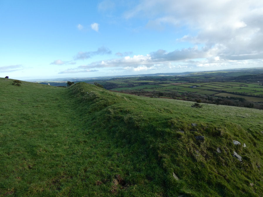
Photo taken on 03-12-2025
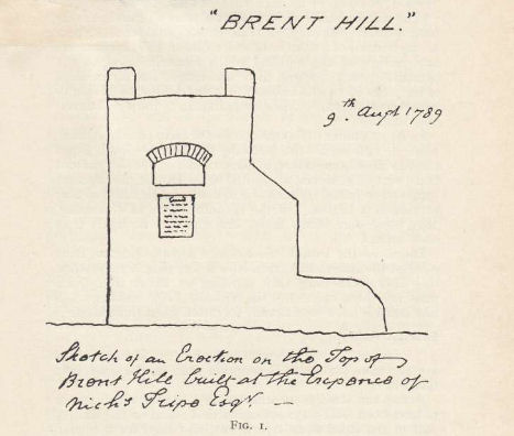
Worth (1941): Sketch of an Erection on the Top of Brent Hill, built at the Expence of Nichs. Tripe, Esq.
Database entries
PDW coverage: Dartmoor Resource: Table of Devon Iron Age Forts
OS Map: SX 70394 61725
OS Source: Google
HER: MDV7957
Megalithic Portal: 7753
Alternate name: Brent Hill
Short Name: FT:Brent Hill
Exist: Yes
Record: Unique
Record Source: PDW
Hut Class: No
Lidar: SX 70394 61725
Nearest Bus Stop: South Brent Pool Park (2.3 km) [Route: 38]
Nearby sites: SX 70394 61725
Notes
This monument includes a slight univallate hillfort with outworks, hut circle platforms and beacon situated at the summit of the prominent Brent Hill. The hillfort survives as an irregularly shaped enclosure surrounding the summit of a naturally steep and rocky hillside which is further enhanced by a partial rampart and ditch. There is an extension to the rampart circuit on the south western side where natural defences are weaker and to the south east a second outwork in the form of a short length of outer rampart and partially buried ditch connects with steeper natural slopes to the north west and south east. The artificial ramparts are best preserved to the south and attain an overall maximum width of approximately 9m. The original entrance is to the north east where the outwork adds additional protection. The circuit of the rampart is defined almost throughout its entire length by a later field boundary which overlies it.Within the enclosure are the circular platforms of up to three huts which vary in size from 8m to 11m in diameter. There is also a faint rectangular earthwork immediately east of the chapel which survives as a rectangular ditch with an external bank enclosing an area measuring approximately 12m long by 10m wide. The summit of the hill is a well-documented beacon site and it is named 'Brent Beacon' on Ogilby's map of 1675, Donn's Map and Cary's map. Dartington churchwardens' accounts of 1591, 1628 and 1690 list parish contributions for the upkeep of the beacon and the 1591 entry includes items paid for the construction of a house for the watchman. The rectangular structure is often interpreted as this house.
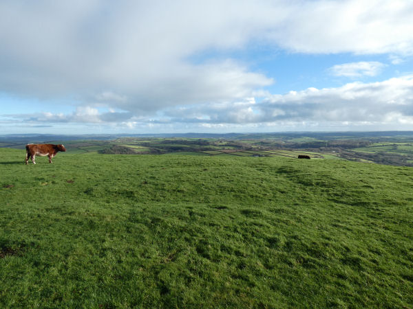
The author visited Brent Hill with Steve Szypko on 03/12/2025 and what follows is the results of exploration on that day.
HER: Hansford Worth publishes a sketch (dated 1789) of a building erected on Brent Hill in 1781, on the site and as a monument to a former building traditionally known as a chapel. The chapel was destroyed in 1777 apparently by lightning, but from the sketch it seems possible that the folly incorporated the remains of the chapel. The 18th century building was of short duration. Rowe, in 1846, reported that there were hardly any vestiges, and it was possibly destroyed in a storm of 1824. The building was commissioned by Nicholas Tripe of Ashburton, the father of Rev John Swete. In the Square under the Arch is a Stone with this Inscription: Monumentum sui aere perennius "A monument more lasting than bronze".
See also: HER entry MDV7936: Chapel of St Michael, Brent Hill
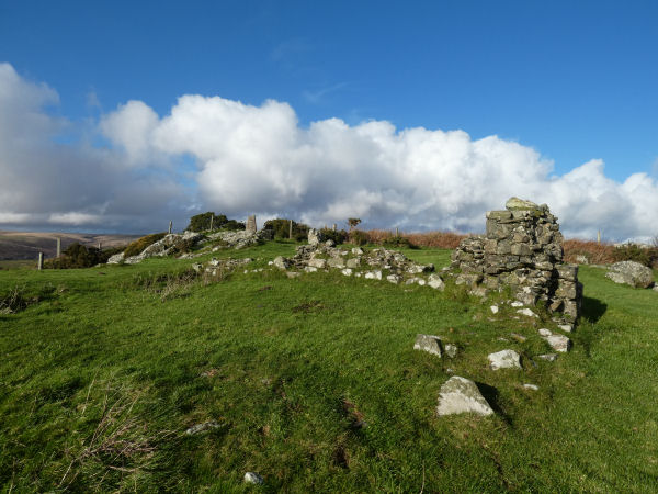
The remains of the ruins on the site of the chapel can be seen in the photo above (taken on 03/12/25). Behind the ruins is the OS trig point and next to that is the remains of the site of the beacon. To the right of the building remains there is a rectangular earthwork that can be seen in the photo below. This might be the remains of the house for the watchman for the beacon. The feature can be seen clearly on the ground and can also be seen on Google Satellite. There appear to be two sections to the feature, a rectangular ditched enclosure. With rectangular platform in the centre. On east, a sub-rectangular low mound (see Greeves on Site of a Beacon).
According to Hoskins there was a windmill built on Brent Hill in 1790 the year after Tripe's monument. There appears to be no solid evidence for the windmill.
Along with the historic period structures there are also evidence of activity in the prehistoric and Roman times. There are 3 platforms for round houses which could be contemporary with the iron age fort or could even predate it in the late bronze age:
Brent Hill 1 Round House
Brent Hill 2 Round House
Brent Hill 3 Round House
Around 1 km to the north is located the site of Bloody Pool. This is the location of one of Greeve's Sacred Pools although this one was filled in. It is located on the roadside and in 1854 a hoard of Bronze Age metalwork was recovered from the pool, including four bronze ferrules, with three barbed bronze spearheads. All items were broken and are thought to have been votive deposits; the only pool on the moor where such items have been found.
Bloody Pool (S. Brent) Ancient Pool
In 2008 a Roman coin hoard was found a little to the east of the fort not far from the road.
Findspot of a coin hoard
Finally, Brent Hill is notable for being different geologically from the granite hills of Dartmoor. It is formed of ironstone and there was once a quarry and also an iron mine on the lower southern slopes. It is the ironstone that makes the location prone to lightning strikes which is what destroyed the original chapel.
Iron Mine
Recommended further reading:
Legendary Dartmoor: Dartmoor’s Brent Hill
Tors of Dartmoor: Brent Hill Summit Tor
References
These are selected references with an emphasis on out of copyright sources linked as PDFs. For more detailed references try any linked HER or PMD record above.
- Gerrard, Sandy, English Heritage Book of Dartmoor: Landscapes Through Time, (1997)
- Page, John Lloyd Warden, An Exploration of Dartmoor and its Antiquities, with some account of its borders, (1889)
- Rowe, Samuel, A Perambulation of Dartmoor (3rd Edition), (1896)
- Silvester, R., The Relationship of First Millennium Settlement to the Upland Areas of the South West., D.A.S.P. No.37 pp.178-179 (1979)
- Worth, R. Hansford, Dartmoor: 1788-1808, T.D.A. Vol.73 pp.203-226 (1941)
- Worth, R.N., Roman Devon (Presidential Address), T.D.A. Vol.23 pp.25-101 (1891)